
East Tiger Mountain Summit Hike
View Photos
East Tiger Mountain Summit Hike
Difficulty Rating:
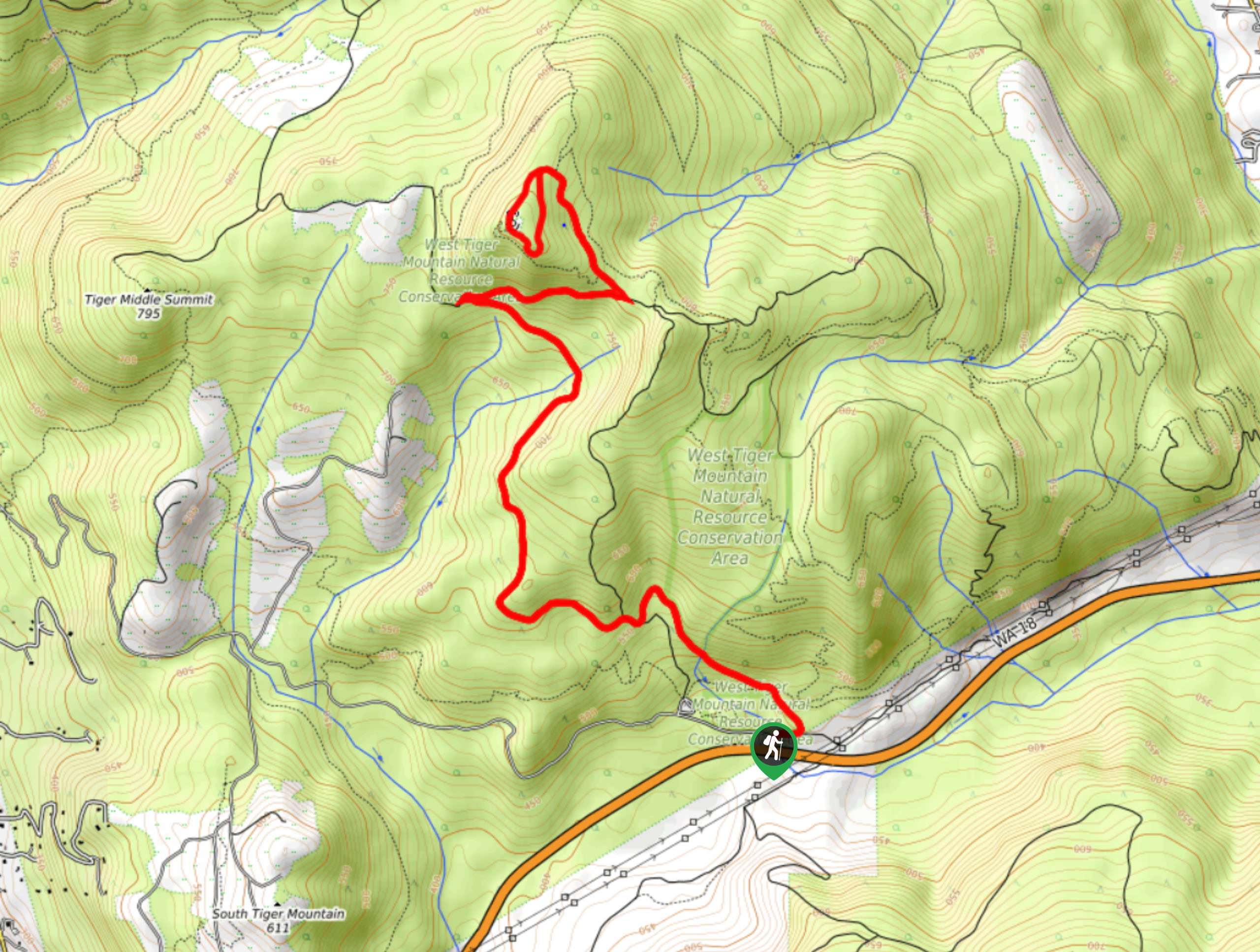
East Tiger Mountain Summit is a 7.7mi out and back hike in Tiger Mountain State Forest. This hike is moderately trafficked by hikers and very popular with mountain bikers, making it important to follow right of way practices as you hike. This trail provides access to two viewpoints, the lower of which has picnic tables you can use. Most of this hike follows an old gravel road, making it easy to follow but potentially a touch less scenic than some others. This trail is less popular than the West Tiger Mountain hike, giving you a better chance of a quieter trail.
This is a constant uphill climb, but you’ll be rewarded with great views of Mount Rainier and the South Sound.
Getting there
The trailhead for the East Tiger Mountain Summit hike is off SR 18 in the parking area for Main Tiger Mountain Road.

About
| Backcountry Campground | No |
| When to do | May-October |
| Pets allowed | Yes - On Leash |
| Family friendly | Yes |
| Route Signage | Average |
| Crowd Levels | Moderate |
| Route Type | Out and back |
East Tiger Mountain Summit Hike
Elevation Graph
Weather
East Tiger Mountain Summit Hike Description
East Tiger Mountain via the Main Tiger Mountain Road is a moderate hike of 7.7mi. With 1657ft of elevation gain, it’s accessible for most strong beginners and better. This trail is popular with mountain bikers more than hikers (who more frequently head up West Tiger Mountain), so keep an eye out and share the trail.
The Main Tiger Road that you’ll take to the summit is an old gravel forest road, not a trail. This makes it very easy to stay on course and offers a wide, even walking surface. You may be less entertained along the way than you would be on a more natural trail, but the views from the two viewpoints make the trip worth it.
Begin from the parking area, heading across Deep Creek to the east. The trail soon splits and you’ll want to stay left. Continue on the path through the next junction and cross Deep Creek again.
You’ll begin to climb gradually. The hike follows a consistent moderate uphill grade the entire way to the summit. You’ll bend around a few wide turns (keep an eye out for bikes).
You’ll pass through another junction, continuing on the gravel road. Wide, relaxed turns lead you through the forest.
In the upper third or so of the hike, you’ll gain elevation a bit more aggressively, but the hike never becomes too steep. You’ll make a tight turn around 730m- avoid the trail that continues straight off the curve of the turn.
Gradually traversing across the mountain, you’ll make another sharp turn around 2625ft. Go straight on here as a spur trail heads to the left. This is the final approach to the summit.
Stop to see the view from a turnout about 0.7mi from the summit, where you can take a breather at the picnic tables if you’d like. Stay right as you loop around the summit. The views from here are actually less clear than the views from the lower viewpoint, but it’s great to be on top of the mountain nonetheless.
You can either retrace your steps or continue off the southeastern side of the summit where the trail loops back on itself to meet up with the main road. Neither option is more difficult than the other.
Back on the main road, you’ll hike down to the trailhead the same way you came up. It bears repeating now that you have your back facing uphill: listen and watch for mountain bikers as you go.
Trail Highlights
Tiger Mountain State Forest
Tiger Mountain State Forest is a 13,745-acre area in Washington State near Seattle-Tacoma that offers opportunities to hike, mountain bike, horseback ride, and more. This forest is one of the DNR’s most well-known forests. With easy access from the cities of the Seattle-Tacoma metro area, it’s a popular choice for many recreationists throughout the year.
Frequently Asked Questions
Can you drive to the top of Tiger Mountain?
No, Tiger Mountain Road is closed to car traffic.
What is the closest city to Tiger Mountain?
Issaquah is the closest city. Preston is also nearby but has fewer services.
Do I need a pass for Tiger Mountain?
Yes, you’ll need your Discover Pass for this hike.
Insider Hints
This hike can be completed in shoulder season if the snow isn’t too deep.
Keep dogs on shorter leashes on shared mountain biking trails.
Similar hikes to the East Tiger Mountain Summit Hike hike

Explorer Falls Hike
The Explorer Falls hike is a 5.3mi moderate hike near Sultan, Washington. This trail takes you to a…

Sky Country to Harvey Manning Loop
The Sky Country to Harvey Manning Loop is a 4.2mi loop trail in the northern part of Cougar…
Black Diamond Coal Mine Trail
The Black Diamond Coal Mine Trail is a 6.7mi moderate trail that is mostly used by mountain bikers.…
Comments