
Black Diamond Coal Mine Trail
View Photos
Black Diamond Coal Mine Trail
Difficulty Rating:
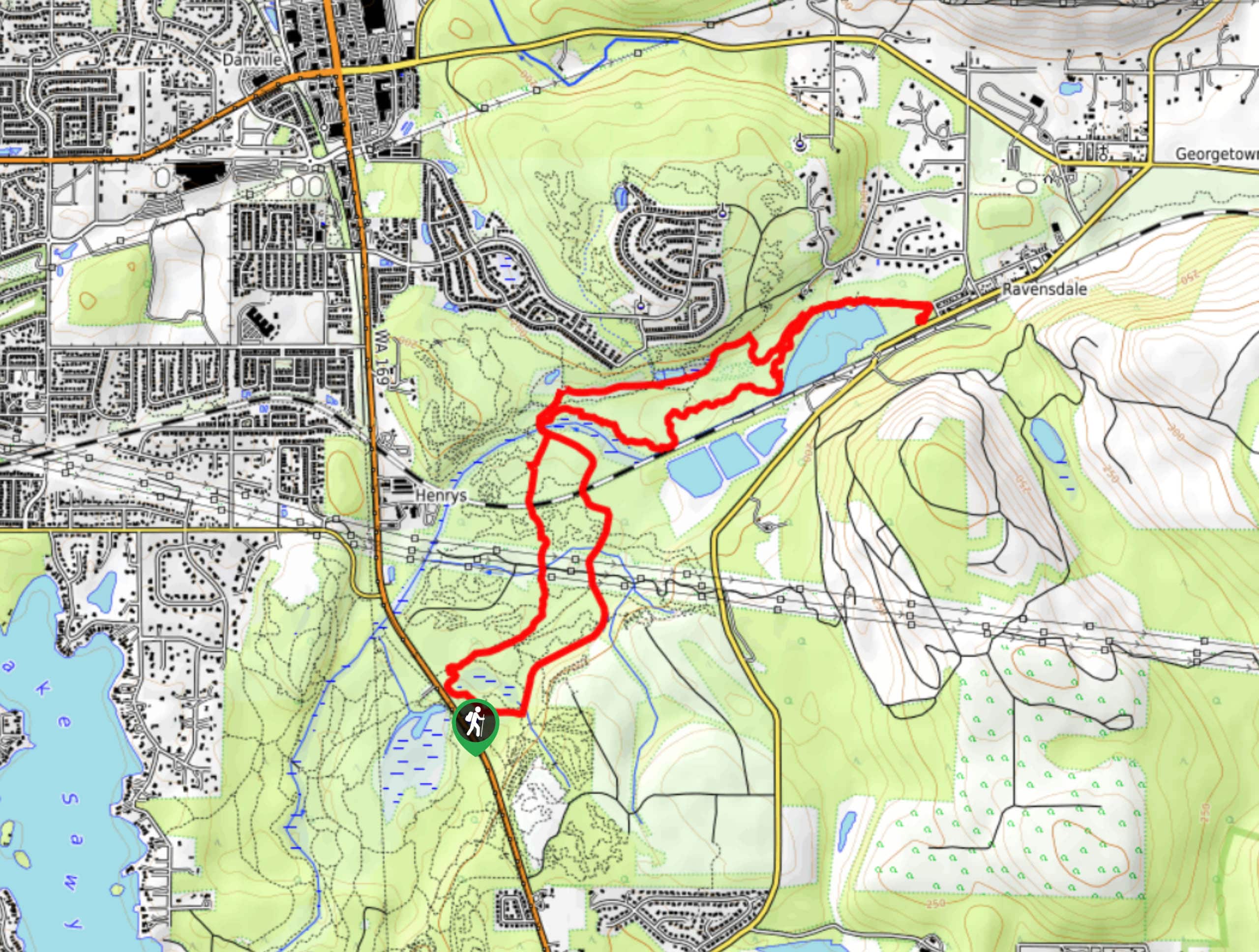
The Black Diamond Coal Mine Trail is a 6.7mi moderate trail that is mostly used by mountain bikers. While hikers are still encouraged to check out the trail, we recommend keeping your eyes and ears open to facilitate good trail sharing. Dogs should be kept on a leash due to the presence of bikers. This trail sees moderate-heavy traffic.
Getting there
The trailhead for the Black Diamond Coal Mine Trail is in the parking area off 3rd Ave.

About
| Backcountry Campground | No |
| When to do | Year-round |
| Pets allowed | Yes - On Leash |
| Family friendly | Yes |
| Route Signage | Average |
| Crowd Levels | High |
| Route Type | Out and back |
Black Diamond Coal Mine Trail
Elevation Graph
Weather
Black Diamond Coal Mine Trail Description
The Black Diamond coal Mine Trail is most frequently used by mountain bikers, but hikers are also able to enjoy this moderate trail. It’s shaded and provides water views. Make sure you share the trail well and look out for bikers as you go.
Begin from the parking lot. There are lots of interconnecting trails in this area, so a downloaded GPS track is recommended. Head left onto Remasterand follow it to Master Link. Take a left onto Route 66 and a right onto Copperhead. Stay right and walk around a tight turn to begin your loop back on Lower Beaver Tracks. Turn left on Route 66 and follow this trail back to the trailhead.
Similar hikes to the Black Diamond Coal Mine Trail hike

Explorer Falls Hike
The Explorer Falls hike is a 5.3mi moderate hike near Sultan, Washington. This trail takes you to a…

Sky Country to Harvey Manning Loop
The Sky Country to Harvey Manning Loop is a 4.2mi loop trail in the northern part of Cougar…
Far Country Falls via Licorice Fern Trail
Far Country Falls via Licorice Fern Trail is a 4.8mi moderate hike in Cougar Mountain Regional Wildland Park…
Comments