West Tiger #3 Trail
View Photos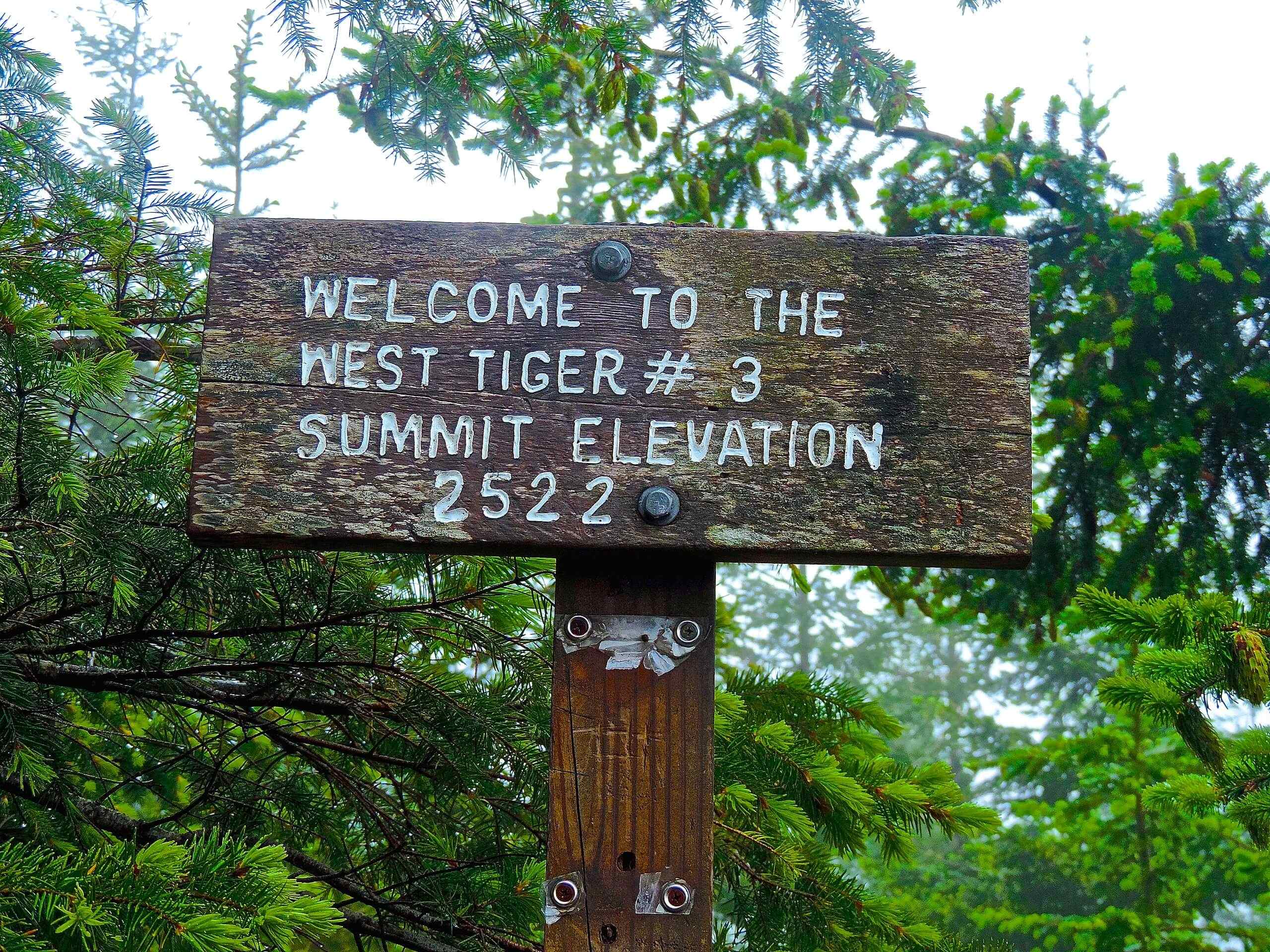
West Tiger #3 Trail
Difficulty Rating:
West Tiger Mountain via West Tiger #3 is an 5.5mi out and back hike in Tiger Mountain State Forest. This hike is heavily trafficked compared to the East Tiger Mountain ascent. It’s also harder, requiring more elevation gain. Despite the challenges, this way up Tiger Mountain is definitely prettier, with a forested trail leading you to a summit that has better views than the east side. This trail is also popular with wildlife enthusiasts, who have spotted everything from owls to bears in the trees.
Logging operations on the mountain can occasionally lead to temporary trail closures. Check with the DNR before visiting for the current status of the trail.
Getting there
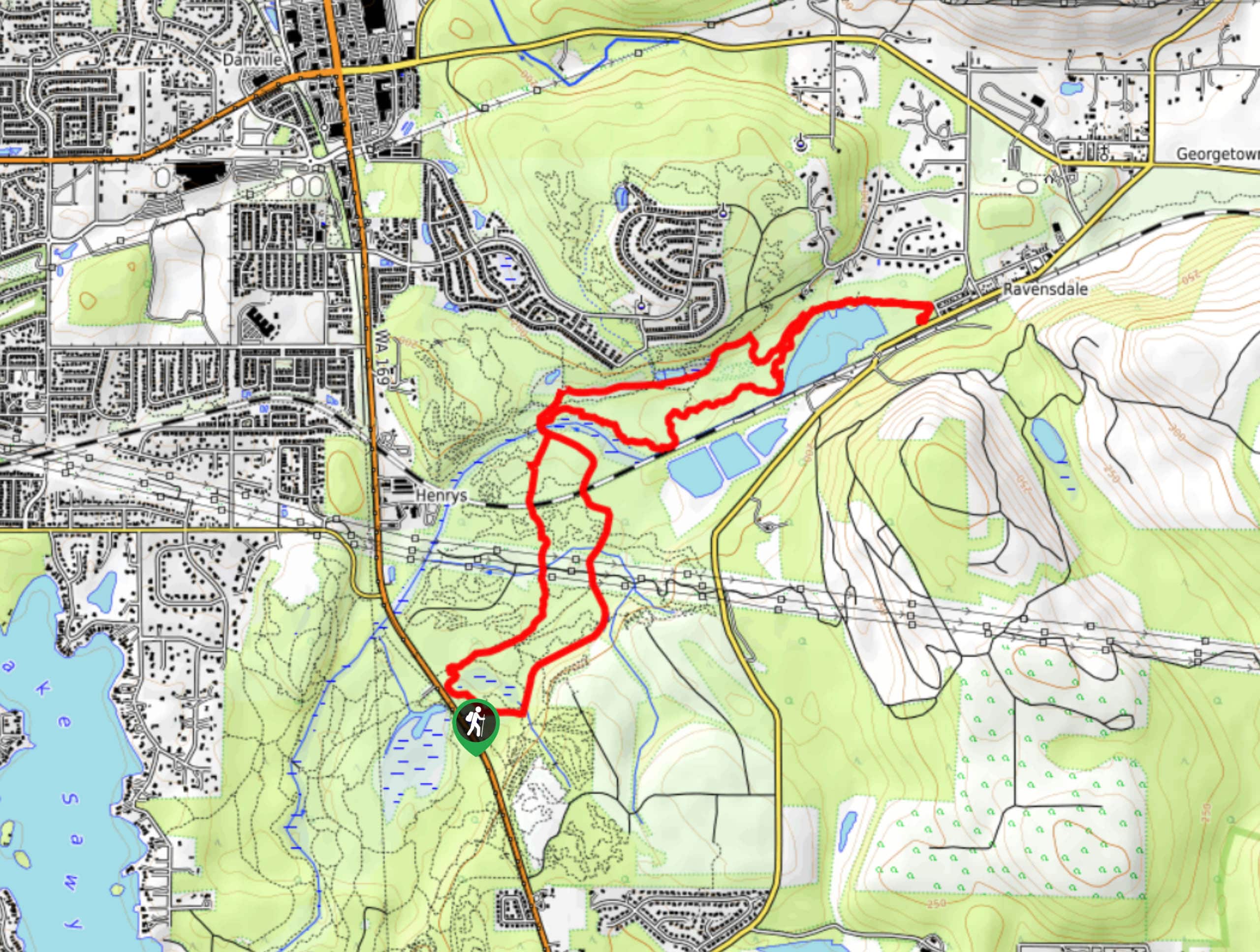
The trailhead for West Tiger #3 is at the end of SE 79th Street off I-90.

About
| Backcountry Campground | No |
| When to do | March-November |
| Pets allowed | Yes - On Leash |
| Family friendly | No |
| Route Signage | Good |
| Crowd Levels | High |
| Route Type | Out and back |
West Tiger #3 Trail
Elevation Graph
Weather
West Tiger #3 Trail Description
West Tiger #3 is the most popular way to climb Tiger Mountain. This trail is hard but not overly challenging, making it a go-to conditioning hike. The proximity to Seattle also draws lots of visitors on nice weekends. At under 5.6mi with 1949ft of elevation gain, it’s a good workout without being too much, so expect a busy trail. Visiting during the week or early in the morning can help mitigate this.
Note that there are a handful of spur trails off this route that can be confusing, so we recommend downloading your GPS route or keeping an eye on your map. That being said, it’s a good trail to choose if you want the option of extending your hike. Most of the hike follows an old logging road, which is wide and easy to walk on.
Begin from the parking lot. There are a handful of trails that leave from here, so take care to end up on the right one. You’ll want to go past the facilities and the information sign and take the trail that heads roughly south.
Go straight through the next two junctions (keeping left and then right) and enjoy a more gradual beginning before things start to pick up.
You’ll make your way through the forest on wide, lazy switchbacks. The trail is consistently steep and steady. At your next junction, stay left, then stay right around the corner of the next switchback turn.
Two switchbacks pass in due time before you’ll begin zig-zagging more narrowly as you approach the summit. At the junction with West tiger RR Grade, stay left to continue up the mountain.
A couple more switchbacks lead you to the Cable Line Trail, where you’ll straighten out and take on the last almost 100m of elevation gain head-on. This portion of the hike flattens out slightly, making the sudden lack of switchbacks somewhat tolerable.
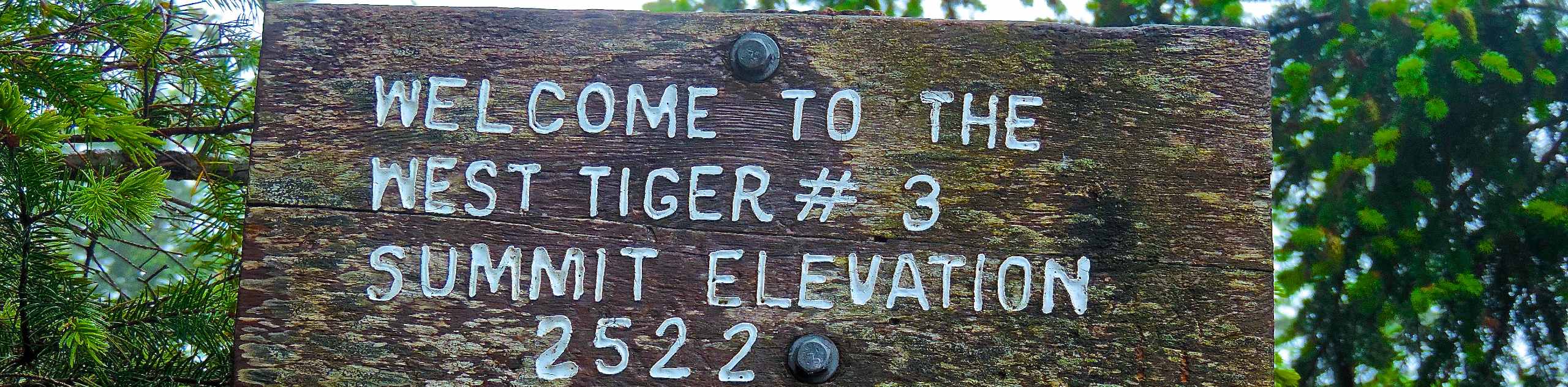
At the top of West Tiger, look out over the surrounding mountains and forest. Look for Mount Rainier and Mount Si. The summit isn’t especially large, but there’s enough room to rest a while before retracing your steps back down the mountain.
Trail Highlights
Tiger Mountain State Forest
Tiger Mountain State Forest is a 13,745-acre area in Washington State near Seattle-Tacoma that offers opportunities to hike, mountain bike, horseback ride, and more. This forest is one of the DNR’s most well-known forests. With easy access from the cities of the Seattle-Tacoma metro area, it’s a popular choice for many recreationists throughout the year.
Frequently Asked Questions
Can you drive to the top of Tiger Mountain?
No, Tiger Mountain Road is closed to car traffic.
What is the closest city to Tiger Mountain?
Issaquah is the closest city. Preston is also nearby but has fewer services.
Do I need a pass for Tiger Mountain?
Yes, you’ll need your Discover Pass for this hike.
Which side of Tiger Mountain should I climb?
Choose East Tiger if you want an easier hike and West Tiger for a bit more of a challenge with better views.
Insider Hints
This hike can be completed in shoulder season if the snow isn’t too deep.
The gate to the parking lot closes at night, so don’t stay out too late.
Similar hikes to the West Tiger #3 Trail hike

Explorer Falls Hike
The Explorer Falls hike is a 5.3mi moderate hike near Sultan, Washington. This trail takes you to a…
Black Diamond Coal Mine Trail
The Black Diamond Coal Mine Trail is a 6.7mi moderate trail that is mostly used by mountain bikers.…

Far Country Falls via Licorice Fern Trail
Far Country Falls via Licorice Fern Trail is a 4.8mi moderate hike in Cougar Mountain Regional Wildland Park…
Comments