
Mount Thomas via Ramona Trail
View Photos
Mount Thomas via Ramona Trail
Difficulty Rating:
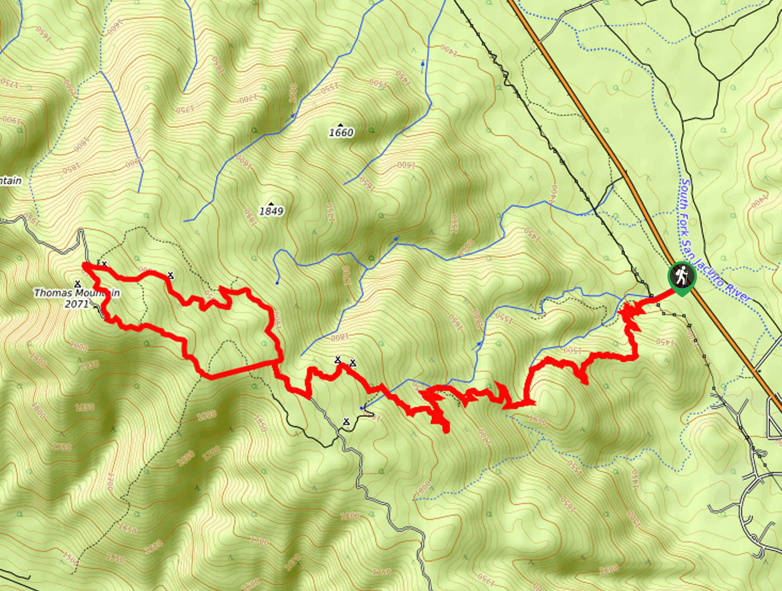
The Mount Thomas via Ramona Trail is an excellent hiking adventure in the San Bernardino National Forest of California that takes you uphill for sweeping views. While out on the trail, you will climb up the forested slopes of the mountain, before pushing up to the summit to enjoy views of San Jacinto Peak to the northeast. As there are several campsites located along this route, it is the perfect hike to pair with a fun weekend of camping outdoors.
Getting there
The starting point for hiking Mount Thomas via Ramona Trail can be found along CA-74, just 0.5mi NW of Riverside County Fire Station 53.

About
| Backcountry Campground | Ramona Campground, Yellow Post #4, #6, #8 |
| When to do | Year-Round |
| Pets allowed | Yes |
| Family friendly | No |
| Route Signage | Average |
| Crowd Levels | Moderate |
| Route Type | Lollipop |
Mount Thomas via Ramona Trail
Elevation Graph
Weather
Mount Thomas via Ramona Trail Description
Whether you are in the mood for a great weekend of camping outdoors or simply want to hit the trails and enjoy some amazing views of the surrounding California landscape, hiking up to Mount Thomas via the Ramona Trail is a fun adventure that will check all the boxes.
Setting out from the trailhead, you will make your way to the southwest and immediately begin climbing up the mountainside. As you zig-zag up the forested slope you will continue to gain elevation and an increasingly beautiful view overlooking the valley landscape.
After passing through the Ramona Campground, you will keep left at a fork in the trail and continue climbing uphill to the northwest, eventually reaching the summit of Mount Thomas for some stunning views out to San Jacinto Peak. From the summit, you will head downhill to the north until you meet up with the road and follow it to the right, passing by two Yellow Post campsites. Eventually, you will turn left onto your original path, follow it past the Ramona Campground and downhill to the trailhead where you began.
Similar hikes to the Mount Thomas via Ramona Trail hike

Palm View Peak Trail
The Palm View Peak Trail is a great hiking route in the San Bernardino National Forest that features a solid…

Cram Peak Ridge Trail
The Cram Peak Ridge Trail is a fantastic, albeit difficult, hiking route in the San Bernardino National Forest that will…
Highway 138 VOE Trail
The Highway 138 VOE Trail is a fantastic hiking route north of the Valley of Enchantment that will see you…
Comments