Gable Lakes Trail
View Photos
Gable Lakes Trail
Difficulty Rating:
A challenging route within Inyo National Forest, the Gable Lakes Trail leads you through stunning alpine terrain before arriving at a set of picturesque lakes and an abandoned mining site. A lightly trafficked route, it is unlikely that you will see many others along the Bale Lakes Trail.
Getting there
The trailhead of Gable Lakes Trail is located off of Pine Creek Road.

About
| Backcountry Campground | No |
| When to do | July-September |
| Pets allowed | No |
| Family friendly | No |
| Route Signage | None |
| Crowd Levels | Low |
| Route Type | Out and back |
Gable Lakes Trail
Elevation Graph
Weather
Gable Lakes Trail Description
Much of Gables Lakes Trail is along uneven terrain, so it is suggested that you wear a good pair of hiking boots. Consider bringing hiking poles with you as well! As Gables Lakes Trail is within the alpine environment of the eastern Sierra Nevada Mountain range, it is important that you monitor yourself and your group members for signs of altitude sickness.
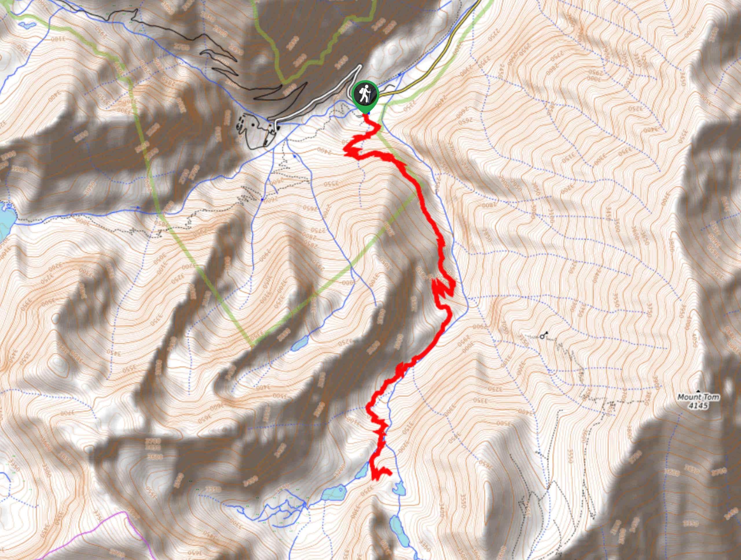
With your vehicle parked, locate the trailhead and begin to follow the Gable Lakes Trail as it makes its way south. Almost immediately, the terrain will begin to incline and the Gable Lakes Trail will turn into a series of switchbacks to help aid you. Having completed the initial switchback section, the route will continue south – traversing a hillside as it goes.
With Gable Creek visible to the west, the Gable Lakes Trail will once again turn into a series of switchbacks before veering southwest alongside the aforementioned creek. The route will then head south, crossing Gable Creek as it goes and arriving at a series of small lakes. After climbing the high ground in the middle of the lakes, Gable Lakes Trail will deliver you to an abandoned mining complex that is fascinating to explore. Once you’re ready, simply backtrack your steps towards the trailhead.
Similar hikes to the Gable Lakes Trail hike

Valentine Lake Trail
An underrated route within Inyo National Forest, Valentine Lake Trail is without a doubt worth the effort! Boasting sublime scenery…

Lakes Basin Path to Pack Trail
A more challenging route within Inyo National Forest, Lakes Basin Path to Pack Trail is ideal for more experienced hikers…
Cottonwood Lakes and Army Pass Trail
Cottonwood Lakes and Army Pass Trail is a scenic route within the high alpine environment of the eastern Sierra Nevada…
Comments