
Valentine Lake Trail
View Photos
Valentine Lake Trail
Difficulty Rating:
An underrated route within Inyo National Forest, Valentine Lake Trail is without a doubt worth the effort! Boasting sublime scenery characteristic of the eastern Sierra Nevada Mountain range, Valentine Lake Trail is an ideal route for intermediate hikers and families with older children.
Getting there
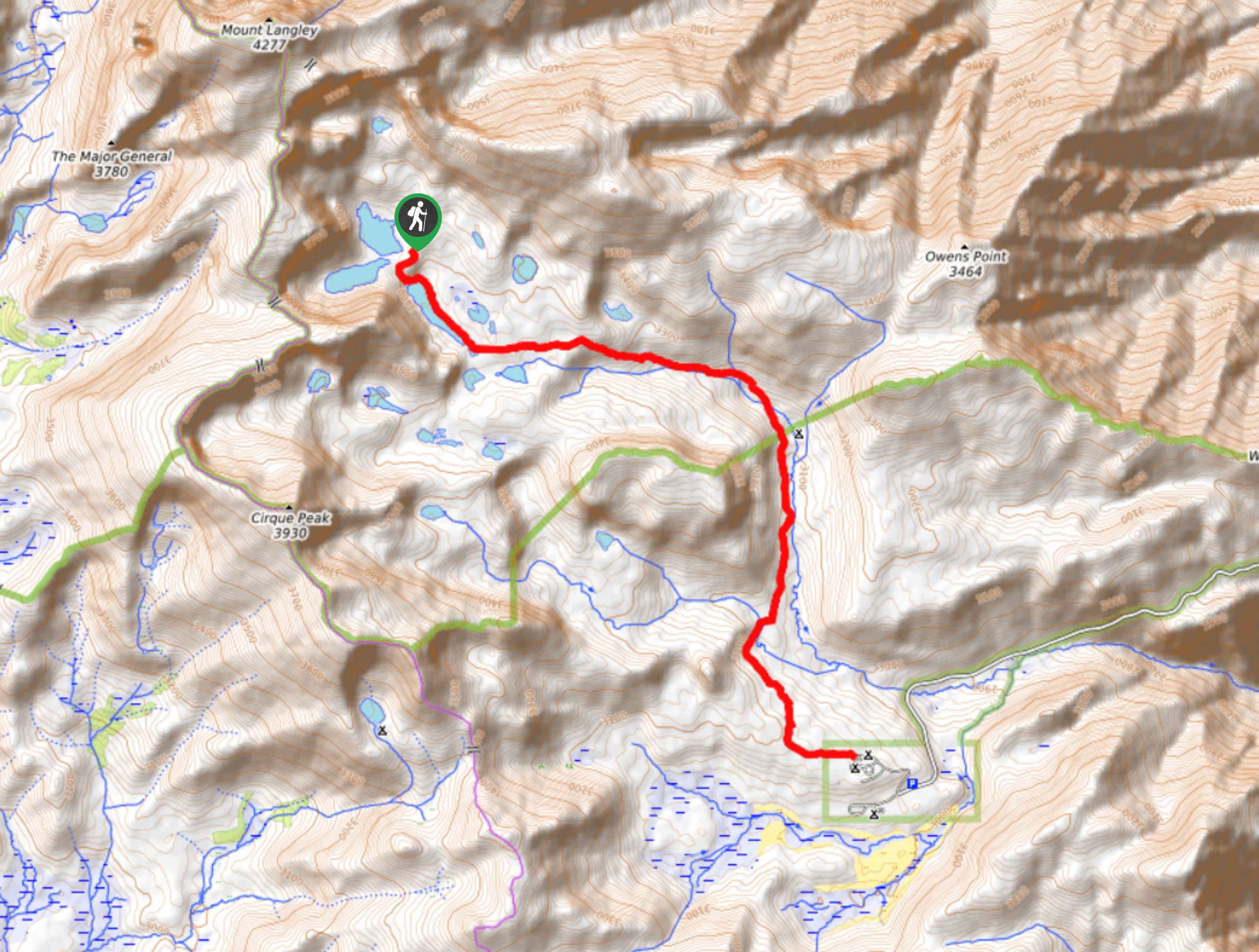
The Trailhead for Valentine Lake Trailhead is located off of Sherwin Creek Road.

About
| Backcountry Campground | |
| When to do | June-November |
| Pets allowed | Yes |
| Family friendly | Older Children only |
| Route Signage | Average |
| Crowd Levels | Moderate |
| Route Type | Out and back |
Valentine Lake Trail
Elevation Graph
Weather
Valentine Lake Trail Description
Sections of the Valentine Lake Trail lack much shade, so it is therefore recommended that you protect yourself from the effects of the powerful alpine sun by wearing sunscreen and a good hat. The Valentine Lake Trail is also within the high alpine environment of the eastern Sierra Nevada Mountain range. This means that altitude sickness is a tangible hazard and that it is important you monitor yourself and your group members for its symptoms.
With your vehicle parked along Sherwin Creek Road, follow the Valentine Lake Trail as it makes its way south. The terrain will begin to incline steadily at first, and then rapidly as the trail turns into a series of switchbacks to help aid you in your climbing of the elevation. After the initial switchback section, the pathway will straighten out and you will soon arrive at a junction within the trail.
At the junction, continue on the Valentine Lake Trail by taking the southern pathway. The trail will travel adjacent to a creek before crossing the creek and veering southwest. The Valentine Lake Trail will then arrive at Sherwin Creek where it will continue south along the creek’s eastern shore. After one last switchback section, the route will deliver you to beautiful Valentine Lake where incredible views of the surrounding landscape can be enjoyed! Once you’re ready, simply backtrack your steps towards the trailhead.
Similar hikes to the Valentine Lake Trail hike

Lakes Basin Path to Pack Trail
A more challenging route within Inyo National Forest, Lakes Basin Path to Pack Trail is ideal for more experienced hikers…

Mountain View and 3S89 Road Loop
Mountain View and 3S89 Road Loop is a delightful route within Inyo National Forest. Leading you through a lovely forested…
Cottonwood Lakes and Army Pass Trail
Cottonwood Lakes and Army Pass Trail is a scenic route within the high alpine environment of the eastern Sierra Nevada…
Comments