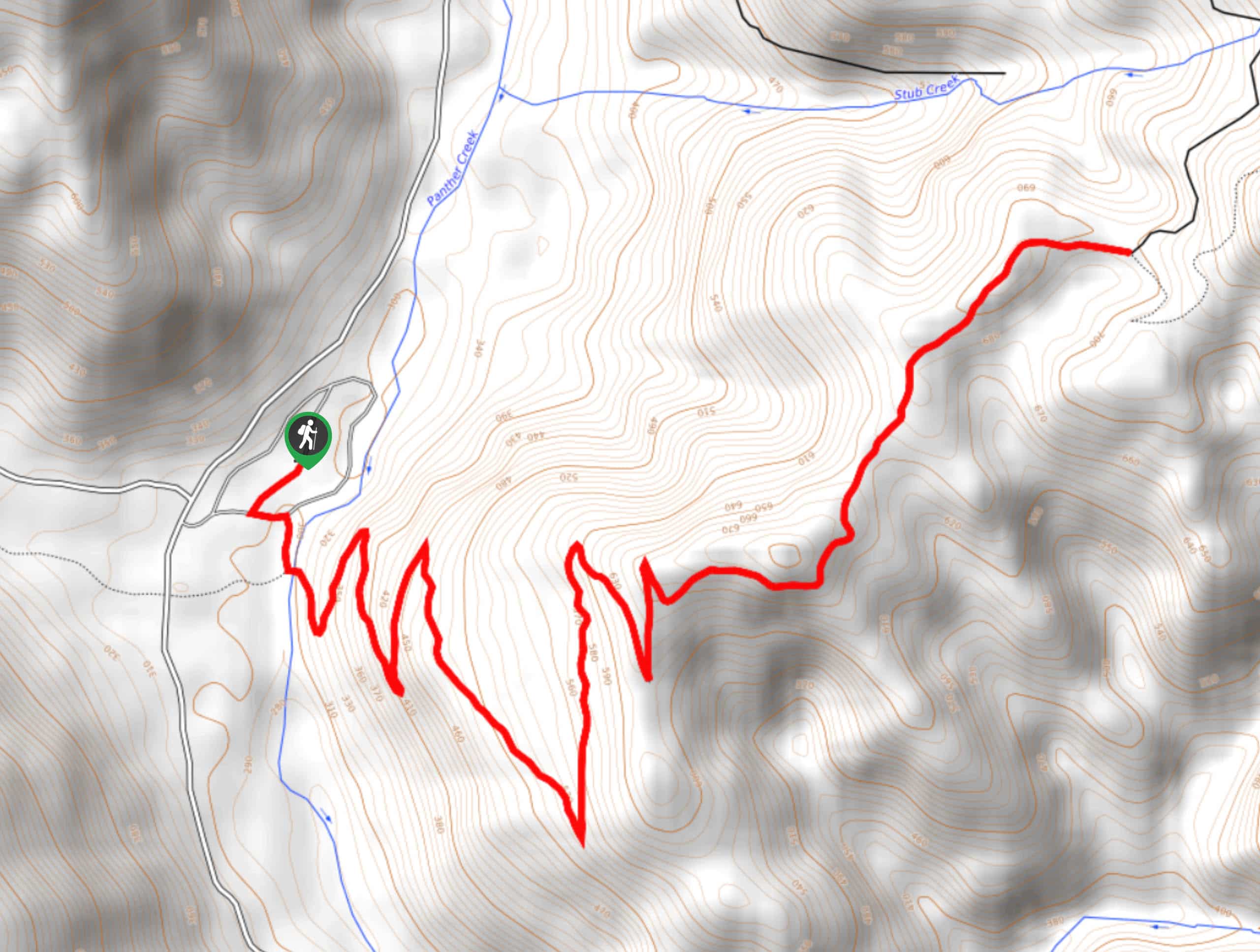
Takhlakh Lake and Meadows Trail
View Photos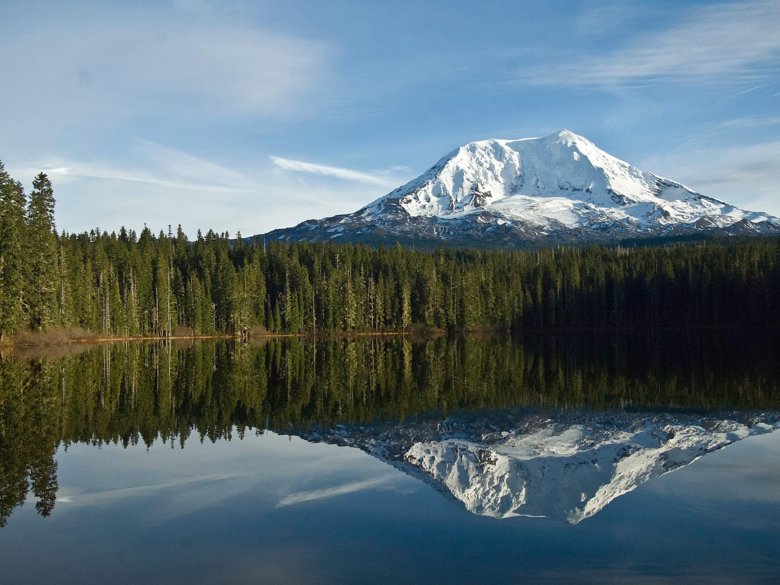
Takhlakh Lake and Meadows Trail
Difficulty Rating:
The 3.3mi loop hike around Takhlakh Lake and the Takh Takh Meadows is a unique hike in the best ways. You’ll climb up an old lava flow for views of Mount Rainier, a uniquely southwestern Washington experience. The hike doesn’t tend to be very busy despite its lovely views.
This trail is rated as easy and is suitable for all skill levels and ages. The trail begins near the campground, so it’s a great choice for those camping here already, but you can also book a spot if you’re planning on visiting to make a weekend out of it. You can also fish in the lake if that interests you.
Getting there
The trailhead for the Takhlakh Lake and Meadows Trail is at the northwest corner of the lake off Midway Loop Road.

About
| Backcountry Campground | Takhlakh Lake Campground |
| When to do | May-November |
| Pets allowed | Yes - On Leash |
| Family friendly | Older Children only |
| Route Signage | Average |
| Crowd Levels | High |
| Route Type | Loop |
Takhlakh Lake and Meadows Trail
Elevation Graph
Weather
Takhlakh Lake and Meadows Trail Description
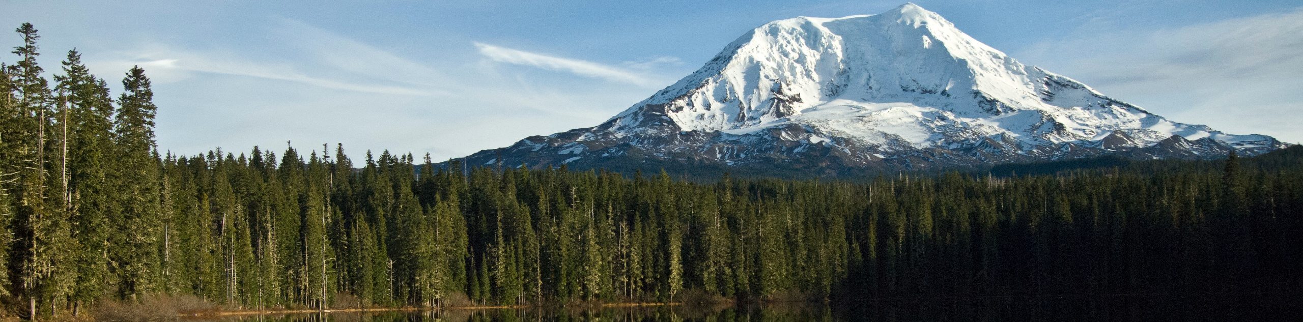
Takhlakh Lake is a pretty spot surrounded by trees and mountains. The surrounding meadow, known as Takh Takh, is a picturesque place to take a hike. This particular trail leads you around the lake and through the meadow to climb a lava flow for excellent views of Mount Rainier. This is a unique trail that thankfully doesn’t get very busy.
There is a campground on the west side of the lake, so this hike is a perfect pick for those here to camp. You can also book a spot to make a weekend out of this pleasant adventure. The lake is good for fishing as well, so bring your gear if you’re interested.
The hike begins from the top of the lake before you get to the campgrounds. You’ll head to your right past the campground, admiring the lake as you round the south side. The trail into the meadows turns off to your right.
You’ll reach the middle of the figure eight, and you can decide whether you go left or right. Left hugs the lava flow and right is a bit flatter. The meadow has the best views of Mount Adams and the best view of Mount Rainier is from the lava flow. Pick which view you want first and hike accordingly.
The left and right arms of this loop meet before the final ascent up the lava flow. You’ll ascend a short distance and then turn back from atop the flow.
Take the opposite arm of the trail and then hike up the northeast side of the lake. Once your hike is done, relax by the lake for a while or set up to fish.
Hiking Route Highlights
Takhlakh Lake
Takhlakh Lake is a 33-acre natural lake in Skamania County that is a popular site for camping and hiking. The lake is situated 7.3mi northwest of Mount Adams, which makes the view from the lakeshore and campground especially appealing. The lake is used for boating and fishing and is a popular spot for photographers when Mount Adams reflects clearly in the water.
Mount Adams
12,281-foot Mount Adams is the second-highest mountain in Washington State. Originally named Pahto or Klickitat, it rises above the Cascade Range in the southern portion of the state. Although Mount Adams has not erupted in over 1,000 years, it’s still considered to be potentially active. The mountain was named for President John Adams.
Mount Rainier
The tallest mountain in the state is a dominant part of your view from the lava flows near Takh Takh Meadows. This 14,409-foot stratovolcano is an iconic sight and is clearly visible from your perch on this trail. Mount Rainier is the tallest mountain in Washington State.
Frequently Asked Questions
Is there cell service at Takhlakh Lake?
There is no cell service around the lake for most users. Make sure you have your hiking route downloaded ahead of time!
How do you pronounce Takhlakh?
“TOCK-a-lock.”
Is Takhlakh Lake free to visit?
No, the lake is not free. There is a modest day-use fee.
Insider Hints
There’s a $5 day-use fee per vehicle to visit the lake.
The road to the lake isn’t in great condition, so we recommend taking the drive slowly and bringing a high-clearance vehicle if you have one.
Similar hikes to the Takhlakh Lake and Meadows Trail hike

Ptarmigan Trail
Ptarmigan Trail is a 4.2mi moderate trail near the base of Mount Saint Helens. This trail is suitable…

Silver Creek Trail
Silver Creek Trail is a moderate hike in the Gifford Pinchot National Forest that is suitable for most skill levels.…
Pacific Crest Trail from Panther Creek
This route guide takes you from Panther Creek Campground to the Pacific Crest Trail, offering an easy connector for those…
Comments