
Round the Mountain Trail
View Photos
Round the Mountain Trail
Difficulty Rating:
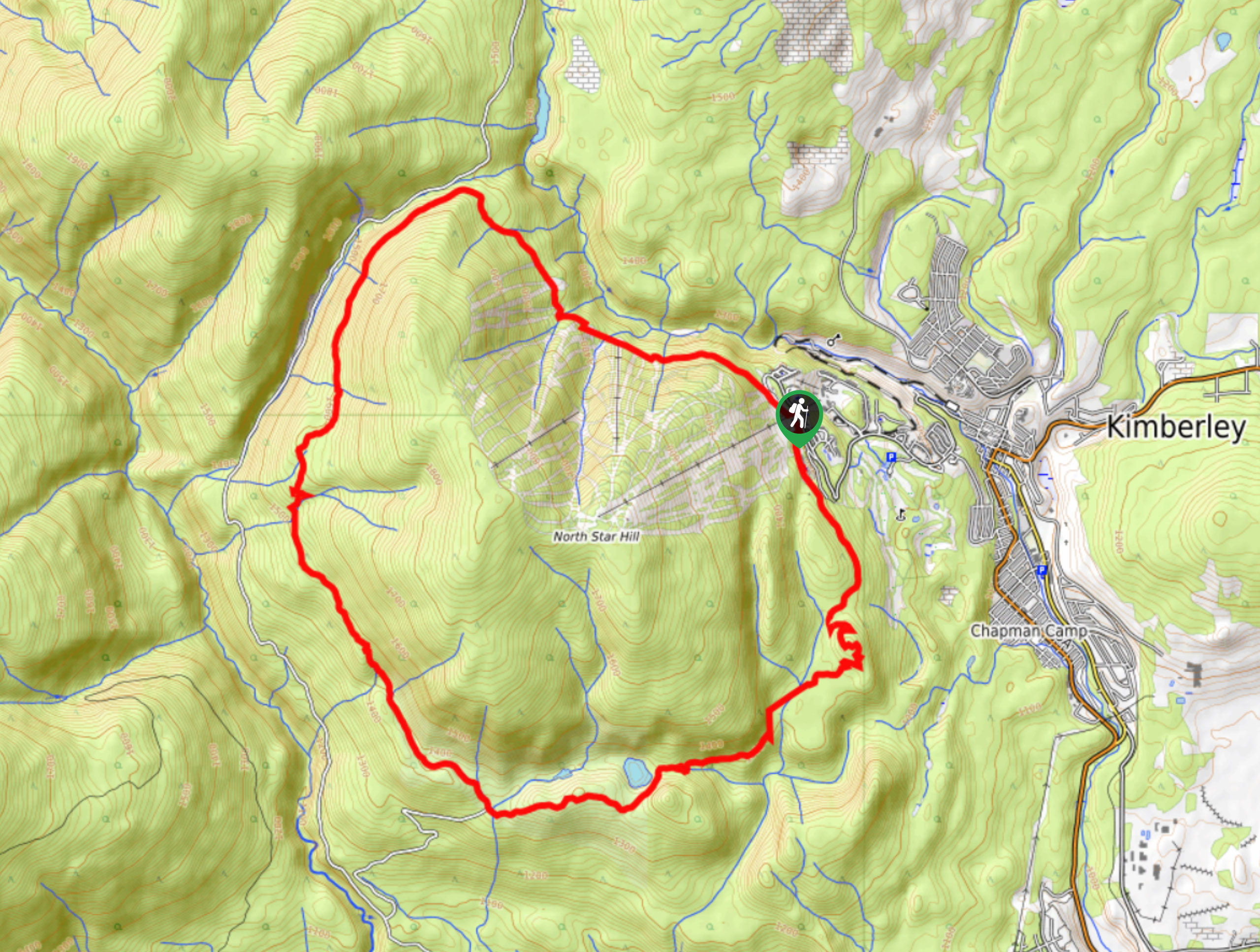
The Round the Mountain Trail is a 12.1mi lollipop hiking route that will take you along the lower slopes of North Star Hill on a path that works all the way around the mountain. Along the hike, you will have some scenic views of the surrounding area from several different viewpoints, and pass by the tranquil waters of Dipper Lake. This trail does feature some elevation gain, so bring plenty of water and wear proper hiking footwear for the long trek.
Getting there
To reach the parking area for the Round the Mountain Trail from Kimberley, drive to the northeast along BC-95A and make a left on Burdett Street. Make a slight right in 951ft onto Norton Avenue and follow it for 2953ft. Turn left onto Gerry Sorensen Way and continue on for 3117ft before turning right on North Star Boulevard. After 1312ft, turn left and you will find the parking area.

About
| When to do | April-October |
| Backcountry Campsites | No |
| Pets allowed | Yes |
| Family friendly | Older Children only |
| Route Signage | Average |
| Crowd Levels | Low |
| Route Type | Lollipop |
Round the Mountain Trail
Elevation Graph
Weather
Round the Mountain Trail Description
The Round the Mountain Trail is one of the longer hiking routes in the Kimberley area and it provides an easy means to experience a full-day adventure. The trail sets out from the Kimberley Alpine Resort, and works around the lower slopes of North Star Hill in a counterclockwise direction. The initial stretch of trail will see you hike through the forest and cross over several small creeks before reaching the northernmost point of the route and following it around the backside of the mountain.
From here, you will have some amazing views of the Purcell Mountains to the northwest as you work your way south towards the heavily forested landscape of the Dipper Lake/Horsebarn Recreation Site. Here, you will follow closely alongside a flowing creek before passing by the calm waters of Dipper Lake. The last leg of the hike works through a densely packed network of trails, so keep your eyes on the GPS, and you will be back at the alpine resort in no time, having completed the Round the Mountain Trail.
Similar hikes to the Round the Mountain Trail hike

Spirit Trail Loop
The Spirit Trail Loop is a 10.1mi hiking circuit in the East Side Columbia Lake Wildlife Management Area,…

Mount Stevens and Teepee Mountain
The trek to Mount Stevens and Teepee Mountain is a steep 8.4mi out-and-back hiking route east of Wasa,…

Ram Creek Hot Springs
Hiking to the Ram Creek Hot Springs will take you on an 6.9mi out-and-back trail that runs along…
Comments