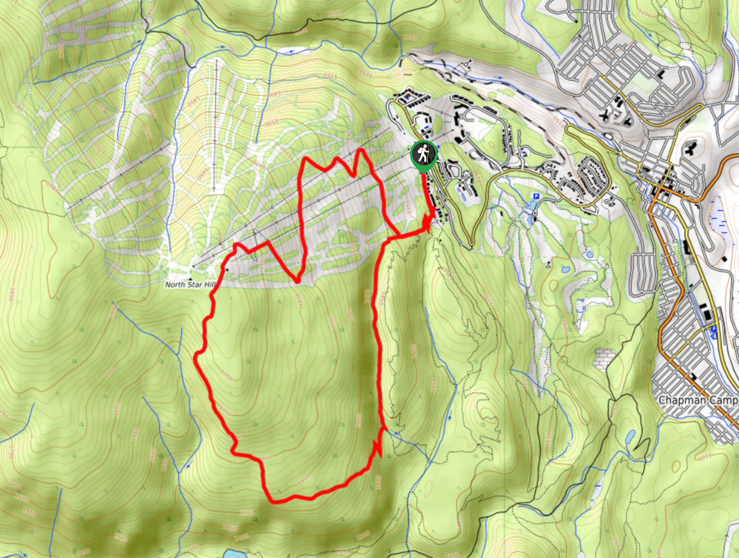
Musser’s Plateau Loop
View Photos
Musser’s Plateau Loop
Difficulty Rating:
Musser’s Plateau Loop is a 6.2mi lollipop hiking route in Kimberley, BC, that climbs up the slopes of North Star Hill and provides hikers with a sweeping view that stretches across the valley. The trail winds uphill along the ski runs at a fairly steep slope that features an elevation gain of 1739ft before descending along the rocky expanse of Moe’s Canyon Trail. Make sure to bring sunscreen, as you will be fairly exposed to the sun on this hike.
Getting there
To get to the trailhead for Musser’s Plateau Loop from Kimberley, drive northeast along BC-95A and turn left on Burdett St. Turn right onto Norton Ave and follow it for 2953ft. Make a left on Gerry Sorensen Way and continue on for 1.2mi. Make a slight left onto North Star Dr., and you will find the trail on the right in 1148ft.

About
| When to do | May-October |
| Backcountry Campsites | No |
| Pets allowed | Yes |
| Family friendly | Older Children only |
| Route Signage | Average |
| Crowd Levels | Moderate |
| Route Type | Lollipop |
Musser’s Plateau Loop
Elevation Graph
Weather
Musser’s Plateau Trail Description
Hiking the Musser’s Plateau Loop is a great way to enjoy the wooded slopes of North Star Hill, even when there is no snow on the ski runs. The trail sets out from the Kimberley Alpine Resort and climbs uphill along the slopes at a fairly steep grade to bring you up to an amazing lookout point. From here, you will have a commanding view that stretches out across the valley to the Rocky Mountains. After taking in the amazing views, begin your descent along the southeastern face of the hill towards the Moe’s Canyon Trail. Here, hikers will need to make their way past a series of rock falls to arrive back at the trailhead next to the resort.
Similar hikes to the Musser’s Plateau Loop hike

Spirit Trail Loop
The Spirit Trail Loop is a 10.1mi hiking circuit in the East Side Columbia Lake Wildlife Management Area,…

Mount Stevens and Teepee Mountain
The trek to Mount Stevens and Teepee Mountain is a steep 8.4mi out-and-back hiking route east of Wasa,…

Ram Creek Hot Springs
Hiking to the Ram Creek Hot Springs will take you on an 6.9mi out-and-back trail that runs along…
Comments