
Chief Isadore Trail
View Photos
Chief Isadore Trail
Difficulty Rating:
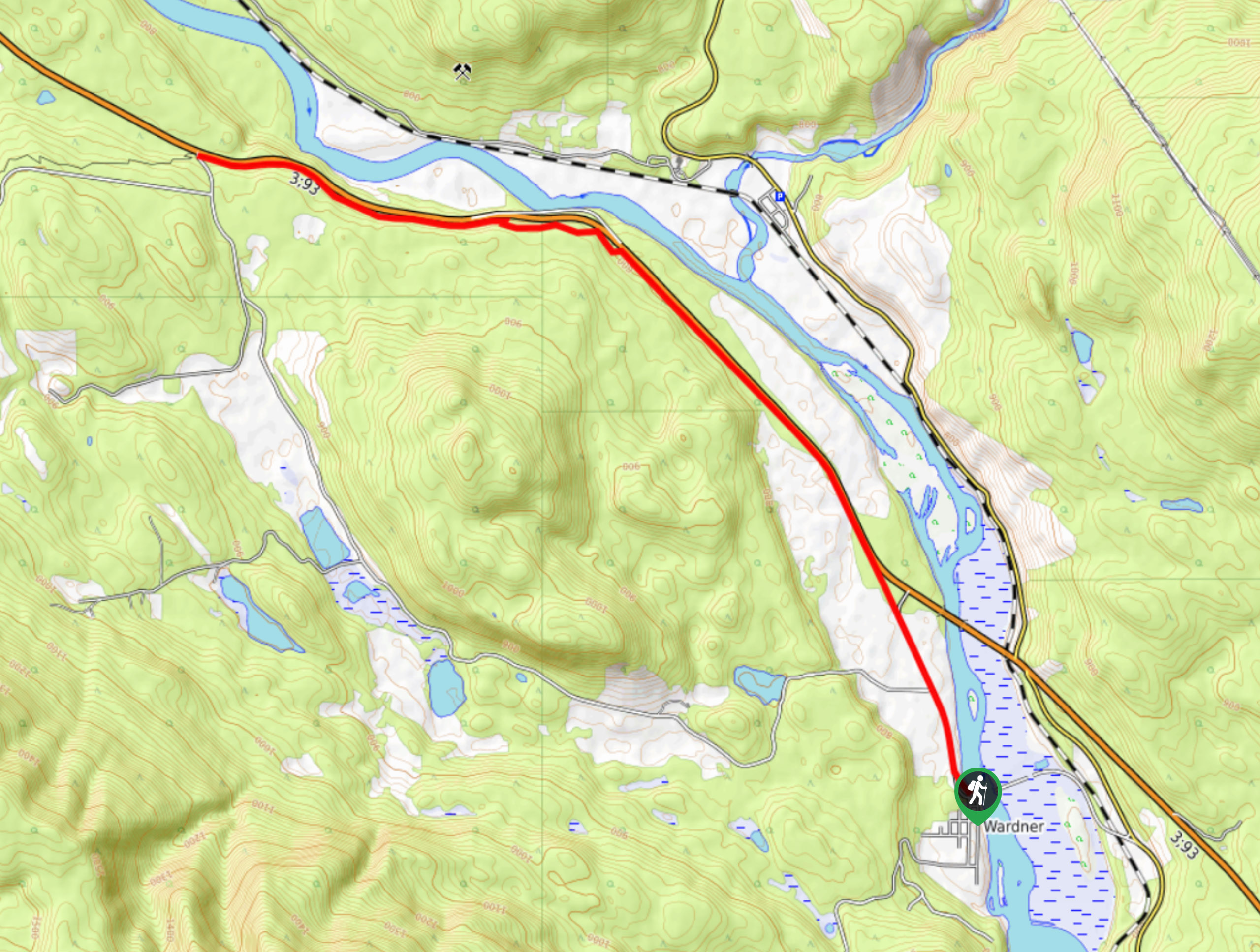
The Chief Isadore Trail is a 6.4mi point-to-point hiking route that will take you from Ha Ha Creek Road to the town of Wardner along a scenic route that runs parallel to the Kootenay River. Hivers along the trail will experience some amazing views across the valley, including the imposing Bull Mountain and The Steeples to the northeast. This route guide is for a one-way trip only, so hikers will need to either hike the return 6.4mi to their vehicle or arrange a pickup in the town of Warden.
Getting there
To reach the trailhead for the Chief Isadore Trail from Jaffray, head west on BC-3 for 12.5mi and turn left onto Ha Ha Creek Road, where you will immediately find the trailhead on the left.

About
| When to do | April-September |
| Backcountry Campsites | No |
| Pets allowed | Yes - On Leash |
| Family friendly | Yes |
| Route Signage | Average |
| Crowd Levels | Moderate |
| Route Type | One Way |
Chief Isadore Trail
Elevation Graph
Weather
Chief Isadore Trail Description
Hiking the Chief Isadore Trail is a great way to get the entire family out on the trails and enjoying the natural beauty of the Kootenay River Valley. Remember that this is a multi-use route, so keep an eye out for trail runners and cyclists along the trail, allowing them enough room to pass safely.
The trail sets out from Ha Ha Creek Road and heads to the southeast on a parallel route to the Crowsnest Highway. Along this initial stretch of the trail, you will pass through a beautiful stretch of forest and experience views across the valley of the imposing rock formations that make up Bull Mountain and The Steeples. Continuing along the trail, you will soon meet up with the Kootenay River before the route turns a bit more sharply to the south in the direction of Wardner. Enjoy the scenic views across the Kootenay River Valley that stretch east towards the Rocky Mountains as you work your way closer to the end of the trail. Once you reach the town of Warden, you can either retrace your steps or utilize your pre-arranged pickup to return to the trailhead at Ha Ha Creek Road.
Similar hikes to the Chief Isadore Trail hike

Spirit Trail Loop
The Spirit Trail Loop is a 10.1mi hiking circuit in the East Side Columbia Lake Wildlife Management Area,…

Ram Creek Hot Springs
Hiking to the Ram Creek Hot Springs will take you on an 6.9mi out-and-back trail that runs along…
Kimberley Nordic Centre Trail
The Kimberley Nordic Centre Trail is an 5.2mi hiking circuit in Kimberley, BC, that will take you through…
Comments