Sunset Peak Trail
View Photos
Sunset Peak Trail
Difficulty Rating:
The Sunset Peak Trail is a wonderful hiking route that can be found in the picturesque Angeles National Forest of Southern California. While out on the trail, you will climb uphill along Sunset Ridge, traversing some rocky terrain in order to reach a beautifully scenic summit viewpoint. Hikers should take note that the road leading into the trailhead closes seasonally, so make sure to check its status prior to setting out on your adventure.
Getting there
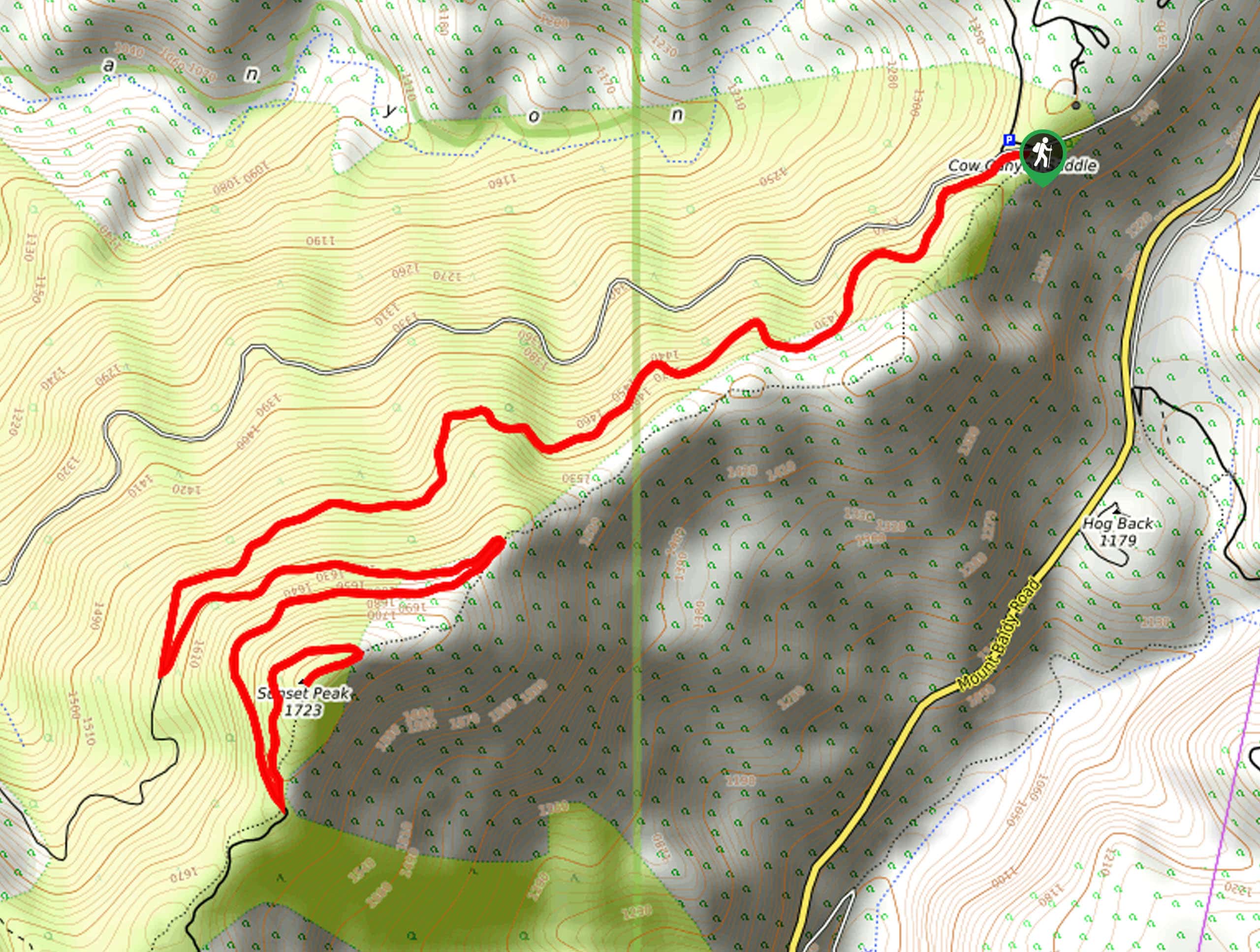
The starting point for this hike can be found at the Sunset Peak Trailhead at Cow Canyon Saddle.

About
| Backcountry Campground | No |
| When to do | May-October |
| Pets allowed | Yes - On Leash |
| Family friendly | Older Children only |
| Route Signage | Average |
| Crowd Levels | High |
| Route Type | Out and back |
Sunset Peak Trail
Elevation Graph
Weather
Sunset Peak Trail Description
Due to the fact that this route follows a fire road for its durations, this is a popular hiking trail in the San Gabriel Mountains. Be sure to arrive early in order to secure a space and beat out the crowds. Additionally, you will need to display an adventure pass in your vehicle when setting out on this excursion.
Even though it can become pretty busy at peak times, this is an excellent hike that offers some truly rewarding views for only a moderate amount of effort. Climbing steadily uphill along the fire road, you will eventually arrive at the summit of Sunset Peak, where you can sit and enjoy the gorgeous views that encompass the surrounding mountain peaks, including the iconic Mount San Antonio. This is one that you certainly won’t want to miss!
Setting out from the trailhead at Cow Canyon Saddle, you will follow the Sunset Ridge Fire Road as it leads to the southwest. For those who want a shorter but more rugged journey, there is a footpath that runs parallel to the road and traverses the ridgeline a bit higher up.
For the purpose of this guide, continue following along the road as it winds through the lightly forested landscape to the southwest for 1.8mi, at which point you will come to a junction. Make a sharp left here and continue along the road as it climbs the undulating mountain terrain to the east.
The trail here will change direction several times, as you make the winding approach to the summit of Sunset Peak. After 1.8mi from the junction, you will arrive at the top of Sunset Peak and experience some breathtaking views that stretch out across the sun-kissed Southern California landscape.
Take a few moments to rest up and revel in the natural beauty of your surroundings, before turning back along the same trail to return to the trailhead. Those who want to experience some slightly different views on the return leg can follow the previously mentioned footpath along the ridge to the northeast to wrap up their time on the Sunset Peak Trail.
Trail Highlights
Mount San Antonio
Often referred to as Mount Baldy or Old Baldy due to its bare summit, Mount San Antonio is a prominent summit in the San Gabriel Mountain Range of Southern California. At 10066ft in height, the peak is the high point of the surrounding mountain range and is instantly recognizable as a landmark in the region. Views from the summit extend out across the expanse of the Angeles National Forest, as well as the Greater Los Angeles area.
Insider Hints
Make sure to wear comfortable hiking footwear.
Keep your dog on a leash at all times.
Bring plenty of water, particularly on warmer days.
Similar hikes to the Sunset Peak Trail hike

Mount Zion via Lower Winter Creek Trail Loop
The Mount Zion via Lower Winter Creek Trail Loop is a physically demanding Southern California adventure that features waterfall and…

Castaic Falls Trail
Hiking the Castaic Falls Trail is a fun little adventure in the Angeles National Forest that features a charming waterfall.…

Graveyard Truck Trail
Hiking the Graveyard Truck Trail is a pleasant experience in Southern California that features easy-going terrain and views of the…
Comments