
Rubio Canyon Trail
View Photos
Rubio Canyon Trail
Difficulty Rating:
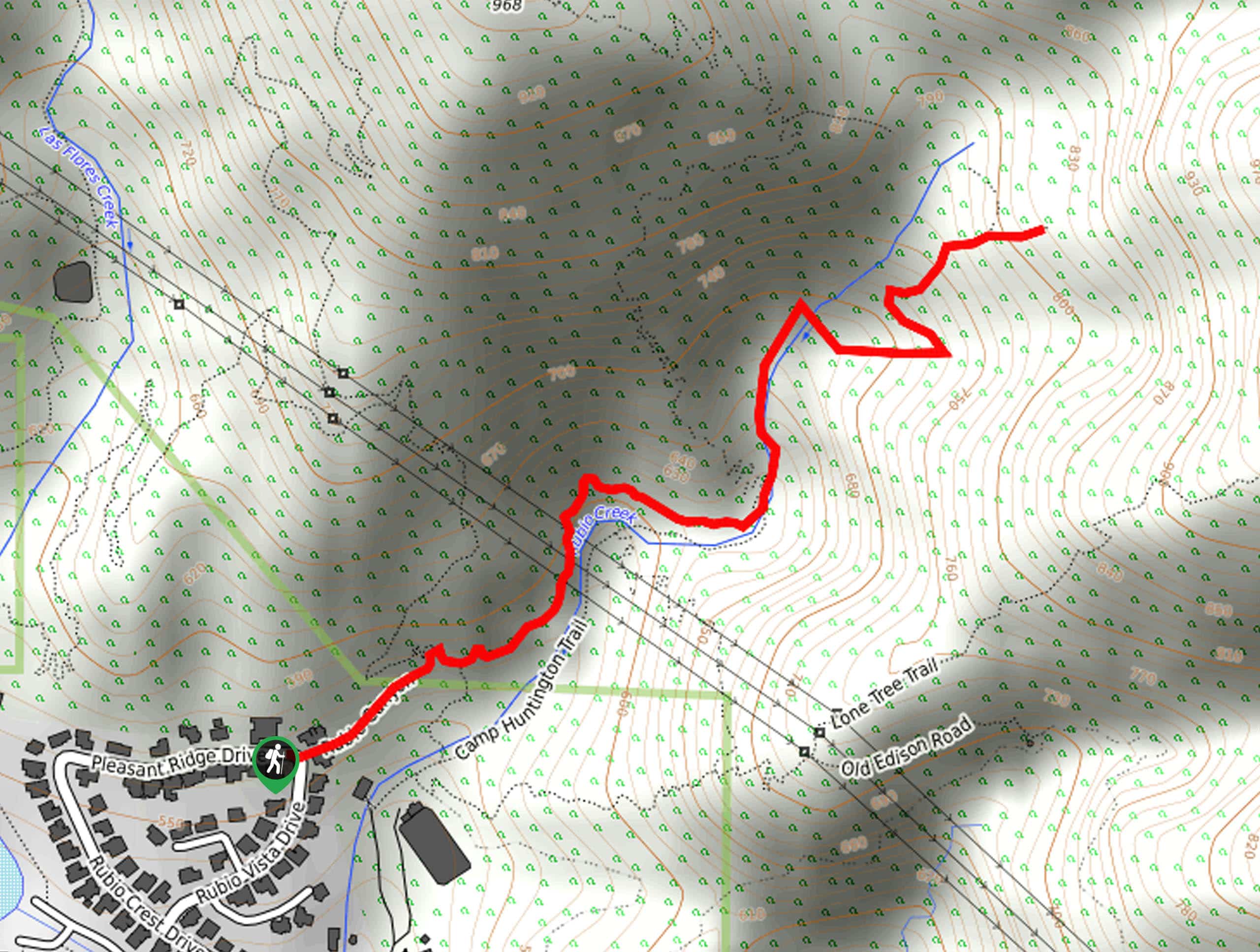
The Rubio Canyon Trail is a short, but deceptively challenging, hiking route in Angeles National Forest that will take you through some rugged terrain to reach a series of waterfalls. While out on the trail, you will traverse the rocky and loose terrain alongside Rubio Creek, often scrambling over rocks or using rope installations to reach viewpoints for the Moss Grotto, Grand Chasm, Thalehaha, and Leontine falls. Make sure to purchase and display your adventure pass in your vehicle prior to setting out on your hiking excursion.
Getting there
The starting point for the Rubio Canyon Trail can be found along Pleasant Ridge Drive in Altadena, California.

About
| Backcountry Campground | No |
| When to do | Year-Round |
| Pets allowed | No |
| Family friendly | No |
| Route Signage | Average |
| Crowd Levels | High |
| Route Type | Out and back |
Rubio Canyon Trail
Elevation Graph
Weather
Rubio Canyon Trail Description
If you are in the mood for a short and easy hike with waterfall views, you might want to take a pass on the Rubio Canyon Trail. While the route is short and features several beautiful waterfalls, there is also a fair amount of challenging rocky terrain that will need to be traversed in order to reach the viewpoints, making this a less than ideal hike for those with little experience or fitness.
Setting out from the trailhead, you will make your way in between two houses along the trail as it leads to the northeast and into Rubio Canyon. Here, you will follow along the edge of Rubio Creek and traverse the rugged terrain in order to reach the scenic vantage points overlooking the Moss Grotto, Grand Chasm, and Thalehaha falls.
Due to erosion, you will need to utilize some installed ropes if you hope to descend below Leontine Falls. After taking in the views, simply head back along the same trail to return to the trailhead where you began your adventure.
Similar hikes to the Rubio Canyon Trail hike

Mount Zion via Lower Winter Creek Trail Loop
The Mount Zion via Lower Winter Creek Trail Loop is a physically demanding Southern California adventure that features waterfall and…

Castaic Falls Trail
Hiking the Castaic Falls Trail is a fun little adventure in the Angeles National Forest that features a charming waterfall.…

Graveyard Truck Trail
Hiking the Graveyard Truck Trail is a pleasant experience in Southern California that features easy-going terrain and views of the…
Comments