
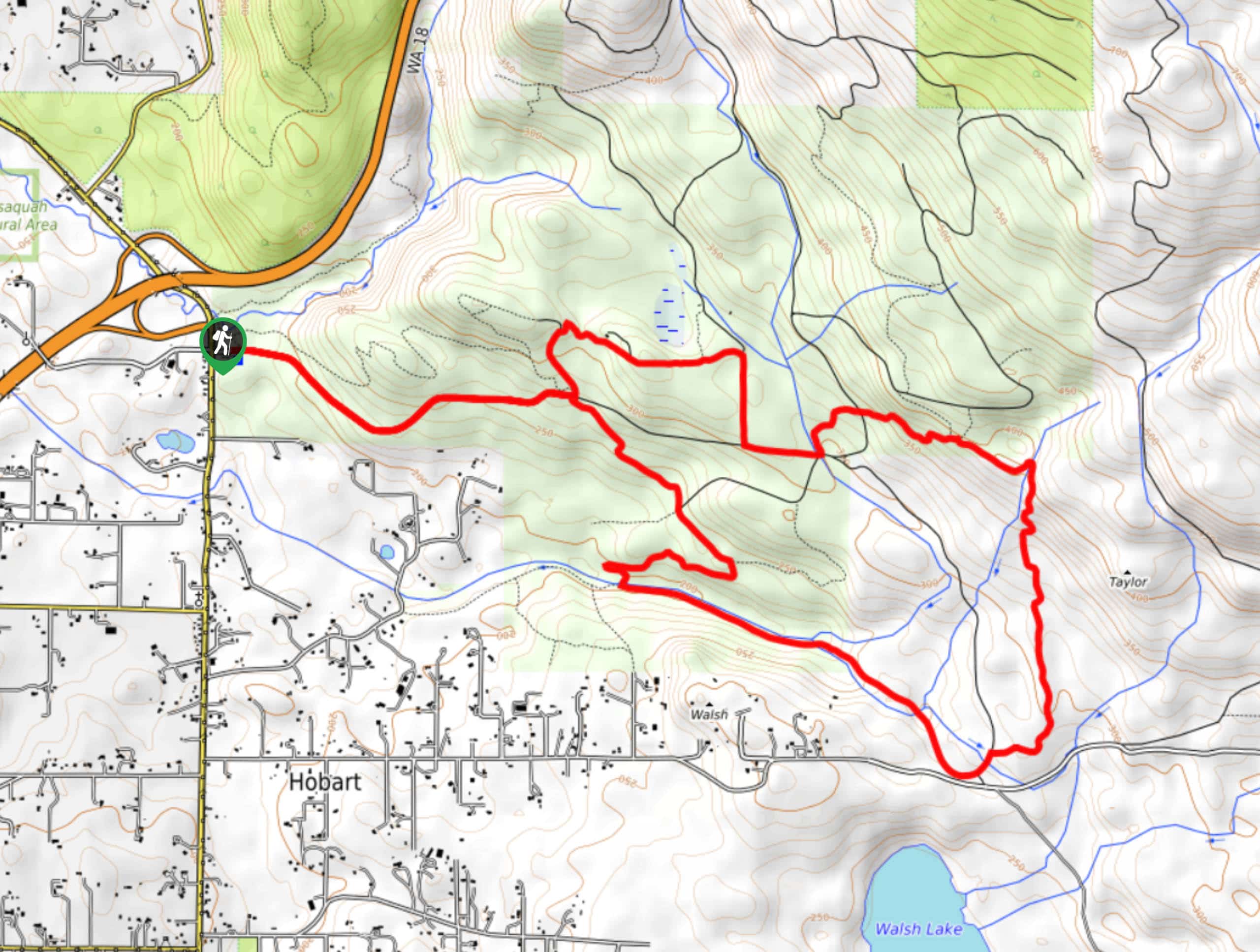
Taylor Mountain Loop
View Photos
Taylor Mountain Loop
Difficulty Rating:
The Taylor Mountain Loop is 8.9mi long and considered moderate. This trail is a favorite for trail runners and casual hikers as it’s not too hard but can still get your heart rate up. Watch for horse traffic and be aware of muddy spots, especially after recent rain. There are lots of connecting trails if you want to keep exploring.
Getting there
The trailhead for the Taylor Mountain Loop is on 298th Ave SE near the intersection with 276th Ave SE.

About
| Backcountry Campground | No |
| When to do | March-October |
| Pets allowed | Yes - On Leash |
| Family friendly | Yes |
| Route Signage | Average |
| Crowd Levels | Moderate |
| Route Type | Loop |
Taylor Mountain Loop
Elevation Graph
Weather
Taylor Mountain Loop Description
The Taylor Mountain Loop is a great mid-distance and elevation hike frequented by hikers, joggers, and equestrians. The trail can get muddy after rain, so walk carefully if it’s slick. Additionally, there are lots of connecting trails, so download your GPS track to stay on trail or if you want to explore a bit further.
Begin from the trailhead, where there are restrooms if you need them. Head on on the trail to the far right called Road A. Follow this to a 5-way junction and take Whiskey Still Trail on the right. Go through the next junction and then go right at the next. At the creek, turn left. Stay right at the Y-junction and then generally keep left around the loop. Take Road A to Southeast 188th Street and then road A again to the trailhead.
Similar hikes to the Taylor Mountain Loop hike

Explorer Falls Hike
The Explorer Falls hike is a 5.3mi moderate hike near Sultan, Washington. This trail takes you to a…

Sky Country to Harvey Manning Loop
The Sky Country to Harvey Manning Loop is a 4.2mi loop trail in the northern part of Cougar…
Black Diamond Coal Mine Trail
The Black Diamond Coal Mine Trail is a 6.7mi moderate trail that is mostly used by mountain bikers.…
Comments