Windy Pass Trail
View Photos
Windy Pass Trail
Difficulty Rating:
The Windy Pass Trail is a great excursion near Pagosa Springs, Colorado that will take you uphill through the forest to reach a scenic viewpoint. While out on the trail, you will gain a fair amount of elevation as you climb through the woodland terrain, before eventually experiencing some beautiful views over the San Juan Mountains from Windy pass. Hikers should take note that there are often downed trees along the trail, so you might need to do a bit of climbing/ducking in order to continue on your hike.
Getting there
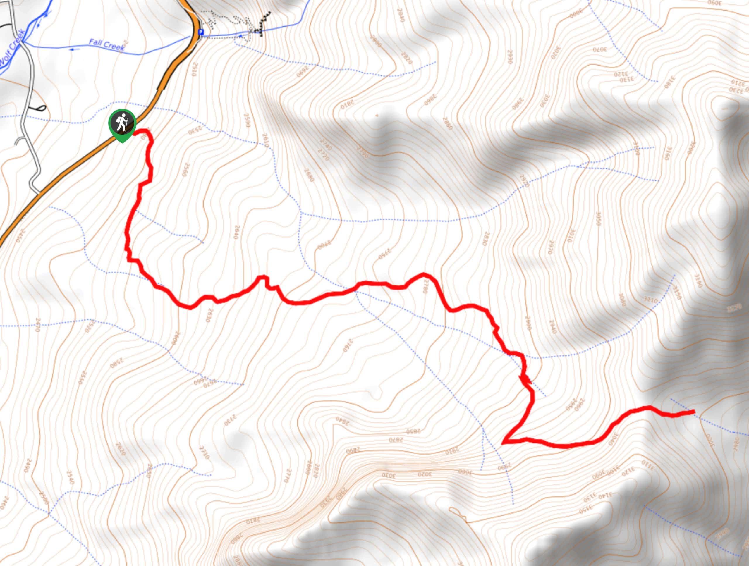
The trailhead for the Windy Pass Trail can be found along US-160, just 14mi northeast of Pagosa Springs.

About
| Backcountry Campground | No |
| When to do | April-October |
| Pets allowed | Yes |
| Family friendly | Older Children only |
| Route Signage | Average |
| Crowd Levels | Low |
| Route Type | Out and back |
Windy Pass Trail
Elevation Graph
Weather
Windy Pass Trail Description
Whether you are looking to complete this hike for the solid leg burn that it will provide going up, the breathtaking views of the surrounding mountains, or a mixture of both, the Windy Pass Trail is a fantastic route near Pagosa Springs that will be sure to deliver.
Setting out from the trailhead, you will make your way through the dense forest to the south and follow the trail as it climbs up the mountain side. After the direction of the path shifts to the southeast, you will pass through several meadows, before arriving at the highpoint of the route at Windy pass.
Here, you will experience some stunning views that sweep across the surrounding landscape to include nearby mountains, valleys, and forests. After taking in the views, head back along the same trail for the return leg.
Similar hikes to the Windy Pass Trail hike

Twin Buttes and Lightner Creek Loop Trail
The Twin Buttes and Lightner Creek Loop Trail is a great hiking route in Durango, Colorado that features some challenging…

Meadow Loop via Horse Gulch Trail
The Meadow Loop via Horse Gulch Trail is a great hiking route in Durango that will take you uphill for…

The Ridge Trail
The Ridge Trail - also known as Raiders Ridge Trail - is an amazing hiking route in Durango, Colorado that…
Comments