
The Ridge Trail
View Photos
The Ridge Trail
Difficulty Rating:
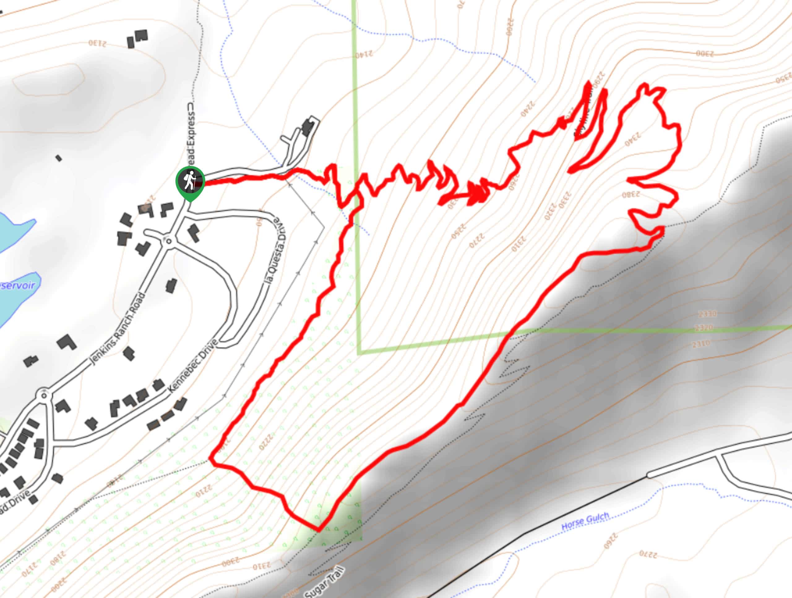
The Ridge Trail - also known as Raiders Ridge Trail - is an amazing hiking route in Durango, Colorado that features challenging terrain and scenic views. While out hiking the trail, you will traverse the steep and rugged terrain of Raiders Ridge, while experiencing beautifully scenic views of Durango and the surrounding area. Be sure to bring a GPS or study the trail map at the beginning of the hike, as some of the junctions along this route are poorly marked.
Getting there
The Ridge Trailhead can be found at the small parking lot along County Road 238, just 1.4mi east of the junction with US-550.

About
| Backcountry Campground | No |
| When to do | April-October |
| Pets allowed | Yes - On Leash |
| Family friendly | Older Children only |
| Route Signage | Poor |
| Crowd Levels | Moderate |
| Route Type | Lollipop |
The Ridge Trail
Elevation Graph
Weather
The Ridge Trail Description
If you live in or are visiting the Durango area and are in the mood for a challenging hike with some beautifully scenic views of the surrounding landscape, then the Ridge trail is a great option to get outside for a good workout.
Setting out from the trailhead, you will follow the Talker Trail as it heads to the southwest and begins climbing gradually uphill to meet up with the Powerline Trail. Here, you will continue on to the southwest for a short distance, before following the trail as it bends to the northeast and climbs up Raiders Ridge.
Taking a path that branches off to the right, you will hike to the northeast along the slope of Raiders Ridge, eventually reaching a highpoint in the northeast corner of the trail that offers beautiful views of the area. Turning back to the southwest, you will traverse the ridgeline and eventually make a descent to meet up with your original trail, following it to the northeast on the return to the trailhead.
Similar hikes to the The Ridge Trail hike

Twin Buttes and Lightner Creek Loop Trail
The Twin Buttes and Lightner Creek Loop Trail is a great hiking route in Durango, Colorado that features some challenging…

Meadow Loop via Horse Gulch Trail
The Meadow Loop via Horse Gulch Trail is a great hiking route in Durango that will take you uphill for…
Skyline Trail from Jenkins Ranch Road
Hiking the Skyline Trail from Jenkins Ranch Road is a great outdoor experience in Durango, Colorado that offers scenic views…
Comments