
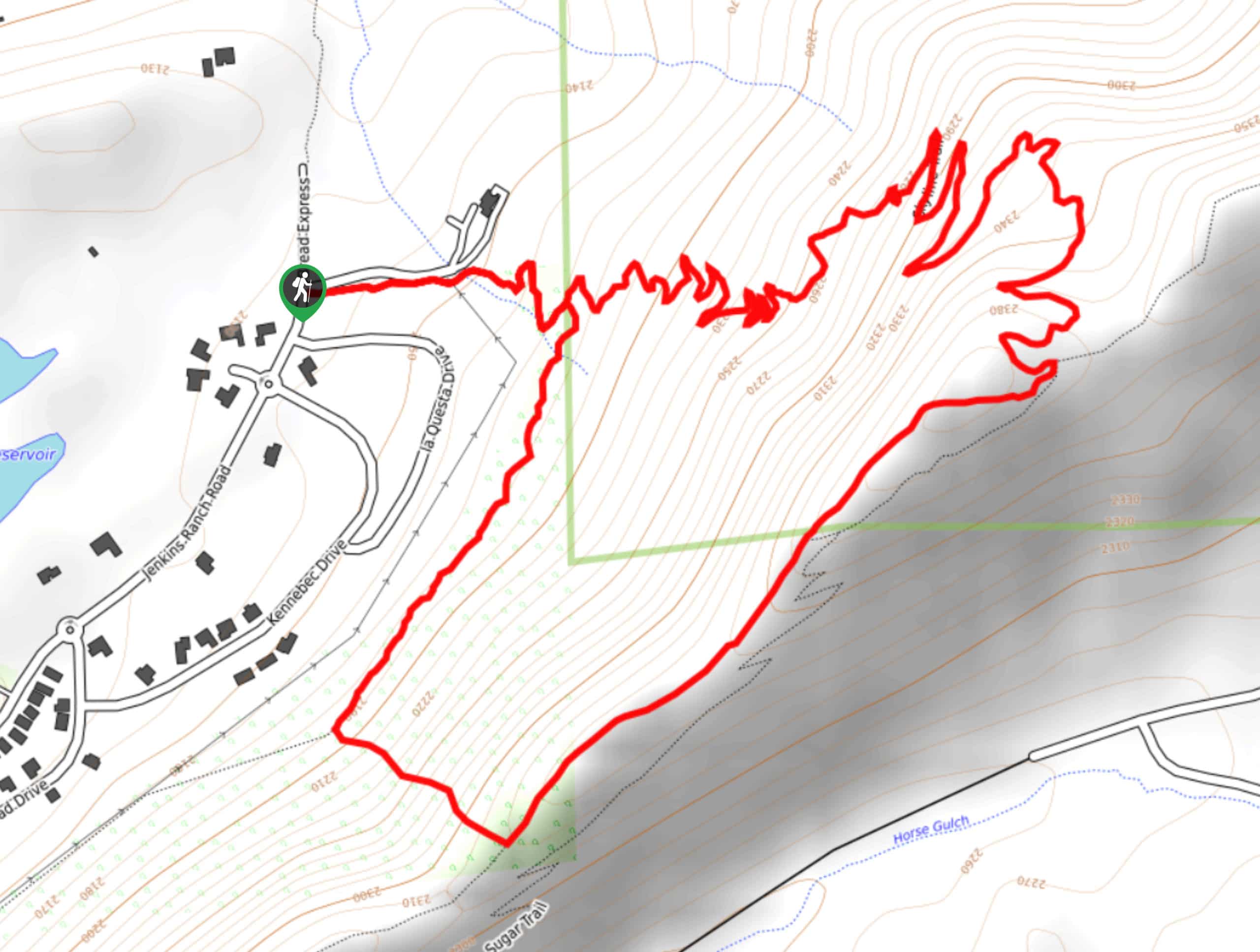
Skyline Trail from Jenkins Ranch Road
View Photos
Skyline Trail from Jenkins Ranch Road
Difficulty Rating:
Hiking the Skyline Trail from Jenkins Ranch Road is a great outdoor experience in Durango, Colorado that offers scenic views of the surrounding landscape. While out hiking the trail, you will climb uphill through a steep series of switchbacks, before taking in the views of the San Juan Mountains and making a very steep descent downhill.Hikers should take note that the turnoff for the trail to descend the hillside can be easy to miss, so bring a GPS if you can to help with navigation.
Getting there
The trailhead for the Skyline Trail from Jenkins Ranch Road can be found at the small parking lot on Jenkins Ranch Road in northeast Durango.

About
| Backcountry Campground | No |
| When to do | May-October |
| Pets allowed | Yes - On Leash |
| Family friendly | Older Children only |
| Route Signage | Poor |
| Crowd Levels | Moderate |
| Route Type | Lollipop |
Skyline Trail from Jenkins Ranch Road
Elevation Graph
Weather
Skyline Trail from Jenkins Ranch Road Description
If you enjoy sweeping landscape views, climbing uphill through tough switchback trails, and steep descents, then the Skyline Trail from Jenkins Ranch Road will be a great option in Durango for you to explore the outdoors.
Setting out from the trailhead, you will make your way to the east along a route that runs parallel to the road, before arriving at a fork in the path. Here, you will turn left and begin working your way uphill through a physically demanding series of switchbacks that will see you gain plenty of elevation along the trail.
Reaching the top of the trail, you will be able to take in the beautiful views of the surrounding landscape, as you make your way to the southwest along a ridge. Turning off to the northwest, you will begin a very steep descent of the ridge, so watch your footing as you work your way downhill. Reaching another junction, turn to the right and follow the path back into the trailhead where you began the adventure.
Similar hikes to the Skyline Trail from Jenkins Ranch Road hike

Twin Buttes and Lightner Creek Loop Trail
The Twin Buttes and Lightner Creek Loop Trail is a great hiking route in Durango, Colorado that features some challenging…

Meadow Loop via Horse Gulch Trail
The Meadow Loop via Horse Gulch Trail is a great hiking route in Durango that will take you uphill for…

The Ridge Trail
The Ridge Trail - also known as Raiders Ridge Trail - is an amazing hiking route in Durango, Colorado that…
Comments