
Silver Lake Trail
View Photos
Silver Lake Trail
Difficulty Rating:
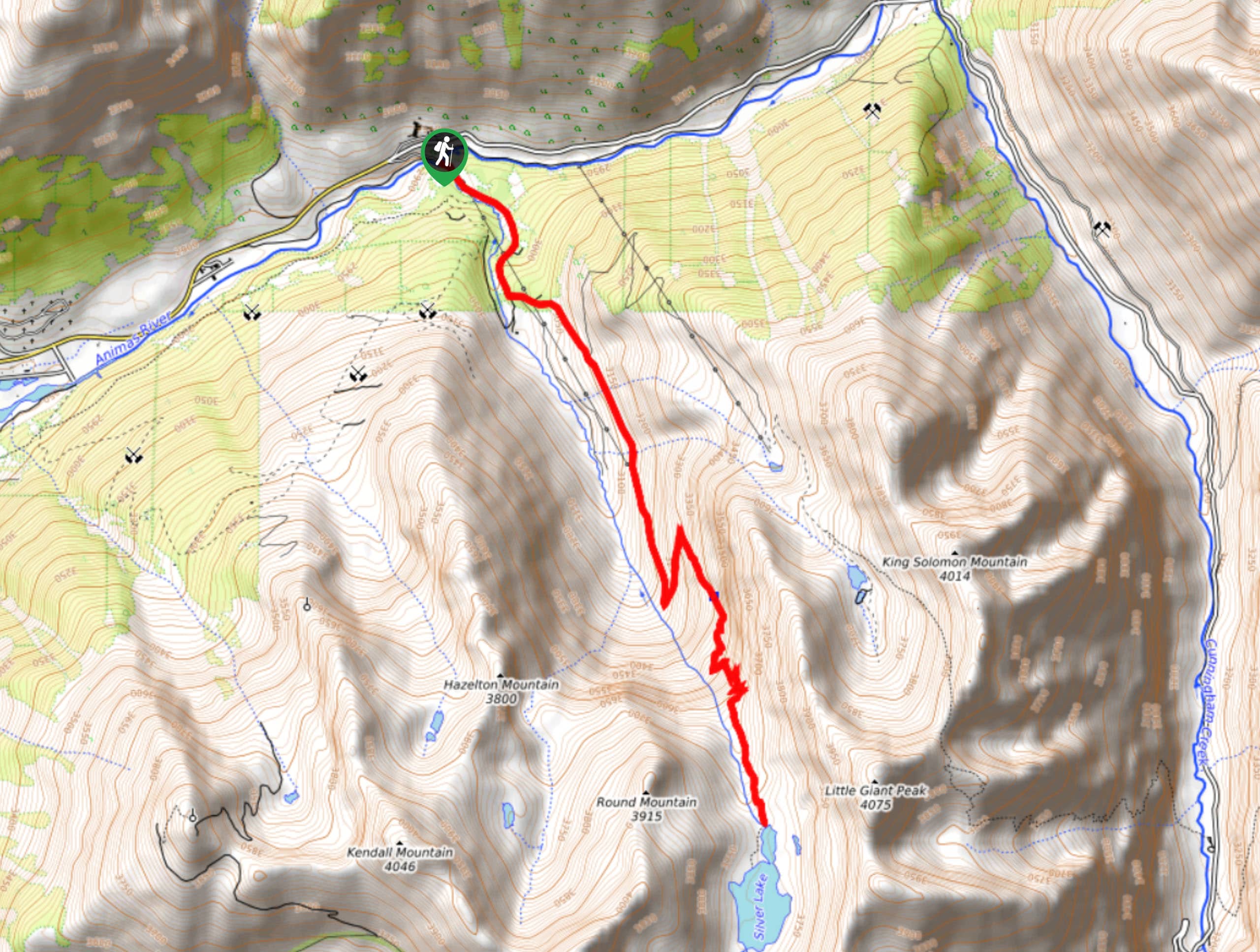
The Silver Lake Trail is a challenging hiking route in the San Juan Mountains that will take you through some alpine terrain to reach the shores of the lake. While out on the trail, you will climb uphill through a forested and rocky valley alongside the Arrastra Creek, where you will eventually arrive at the shores of Silver Lake below the summit of Little Giant Peak. Hikers should take note that this is a difficult route featuring a good amount of elevation gain, so be sure to wear proper footwear, check the weather forecast, and bring any necessary gear and supplies to safely traverse the trail.
Getting there
The trailhead for the Silver Lake Trail can be found along County Road 52 at the bridge crossing over the Animas River, just 2.0mi northeast of Silverton.

About
| Backcountry Campground | No |
| When to do | July-October |
| Pets allowed | Yes |
| Family friendly | Older Children only |
| Route Signage | Average |
| Crowd Levels | Low |
| Route Type | Out and back |
Silver Lake Trail
Elevation Graph
Weather
Silver Lake Trail Description
Featuring rough terrain and a large amount of elevation gain spread throughout the route, the Silver Lake Trail is a fantastic hike that is geared more towards experienced hikers with a good level of fitness. Views along the trail are breathtaking, just be sure to keep an eye out for passing vehicles, as this an off-road trail as well.
Setting out from the trailhead next to the Animas River, you will follow along County Road 52 as it heads to the southeast in a direction parallel to Arrastras Creek. Here, you will climb uphill through the forested valley, before exiting the tree cover into some rocky alpine terrain.
Continuing on to the southeast, you will climb uphill through the valley and traverse the rocky terrain along a series of switchbacks, before eventually arriving at the shores of Silver Lake. Take some time to explore the area and experience the stunning views of nearby peaks like Round Mountain, Kendall Peak, and Little Giant Peak, before heading back down the same way that you came.
Similar hikes to the Silver Lake Trail hike

Twin Buttes and Lightner Creek Loop Trail
The Twin Buttes and Lightner Creek Loop Trail is a great hiking route in Durango, Colorado that features some challenging…

Meadow Loop via Horse Gulch Trail
The Meadow Loop via Horse Gulch Trail is a great hiking route in Durango that will take you uphill for…

The Ridge Trail
The Ridge Trail - also known as Raiders Ridge Trail - is an amazing hiking route in Durango, Colorado that…
Comments