
Redcloud and Sunshine Peaks Hike
View Photos
Redcloud and Sunshine Peaks Hike
Difficulty Rating:
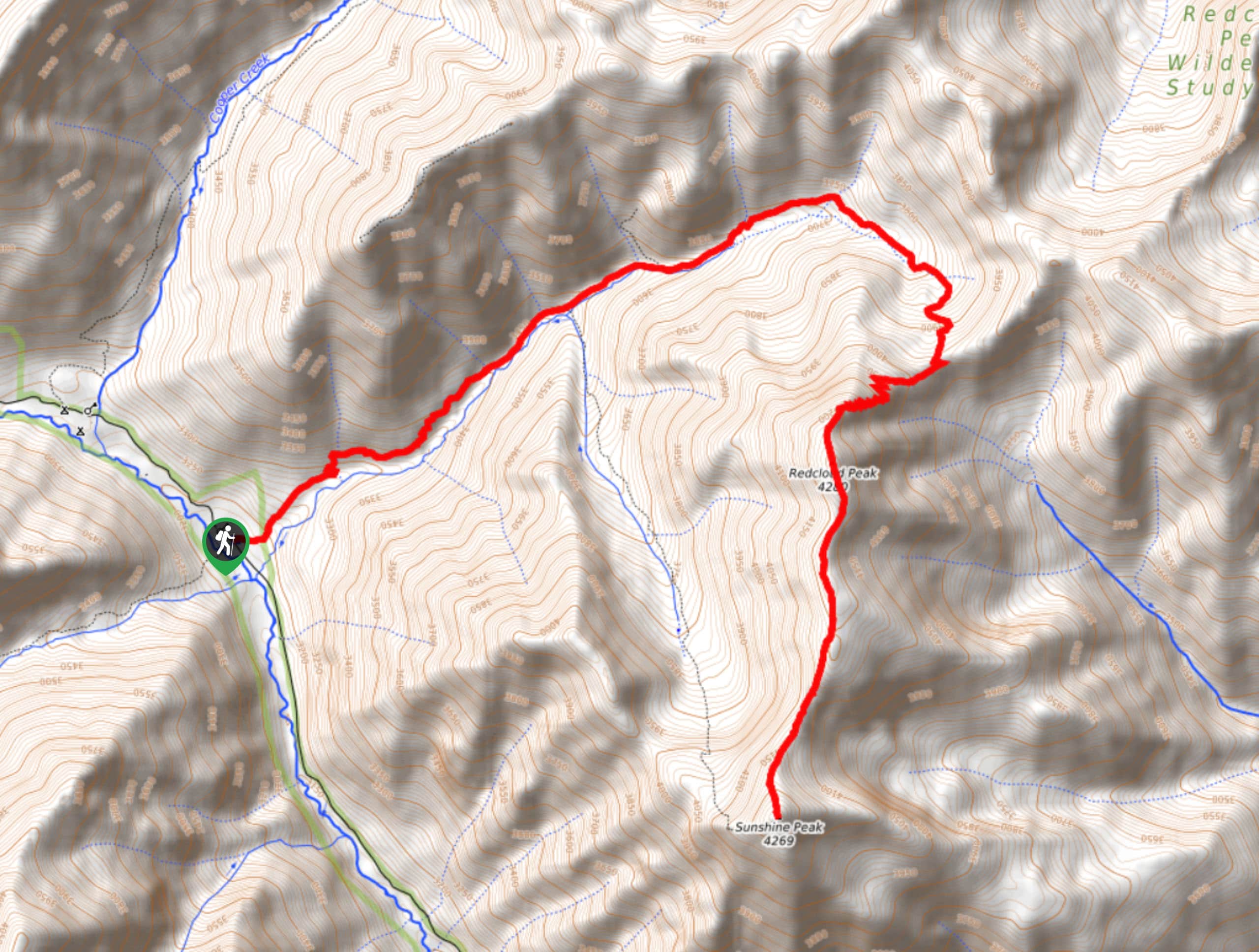
The Redcloud and Sunshine Peaks Hike is a breathtaking, albeit challenging, adventure in the San Juan Mountains of Colorado that will take you to the summit of two fourteeners. While out hiking the trail, you will work your way uphill through a scenic basin, before completing the steep ascent of Redcloud and Sunshine Peaks for some incredible alpine views. Hikers should take note that this is a very difficult route that features exposed sections of trail and is only recommended for experienced climbers.
Getting there
The trailhead for the Redcloud and Sunshine Peaks Hike can be found along Cinnamon Pass Road at the Grizzly Gulch Trailhead.

About
| Backcountry Campground | Burrows Park Dispersed Camping |
| When to do | July-September |
| Pets allowed | Yes - On Leash |
| Family friendly | No |
| Route Signage | Average |
| Crowd Levels | Moderate |
| Route Type | Out and back |
Redcloud and Sunshine Peaks Hike
Elevation Graph
Weather
Redcloud and Sunshine Peaks Hike Description
If you are after a challenging summit adventure with nearly unparalleled views in the San Juan Mountains, then the Redcloud and Sunshine Peaks Hike will be the perfect route for you. This tough day in the mountains will see you traverse the summits of two fourteeners, making for an unforgettable experience in Colorado.
Setting out from the parking area, you will make your way to the northeast as the trail gently climbs uphill for the first half of the hike. Here, you will eventually exit the cover of the forest and continue uphill as the path leads through a beautifully scenic basin. The views here will become increasingly beautiful, as you climb a switchback trail leading up to the saddle.
After pausing for a quick break, you will continue along a ridge to the southwest, traversing the sharp switchback trail and false summit to arrive at the picturesque summit of Redcloud Peak. At this point, you will continue on to the south along another saddle that extends roughly 1.0mi to the summit of Sunshine Peak. The terrain here features some flat portions and steep ones, but is not overly difficult to traverse. Once you are at the summit of Sunshine Peak, take some time to appreciate the views from your second fourteener of the day. From here, you can head back along the same trail or follow the alternate route leading down the opposite slope that will eventually take you back into the same basin.
Similar hikes to the Redcloud and Sunshine Peaks Hike hike

Twin Buttes and Lightner Creek Loop Trail
The Twin Buttes and Lightner Creek Loop Trail is a great hiking route in Durango, Colorado that features some challenging…

Meadow Loop via Horse Gulch Trail
The Meadow Loop via Horse Gulch Trail is a great hiking route in Durango that will take you uphill for…

The Ridge Trail
The Ridge Trail - also known as Raiders Ridge Trail - is an amazing hiking route in Durango, Colorado that…
Comments