
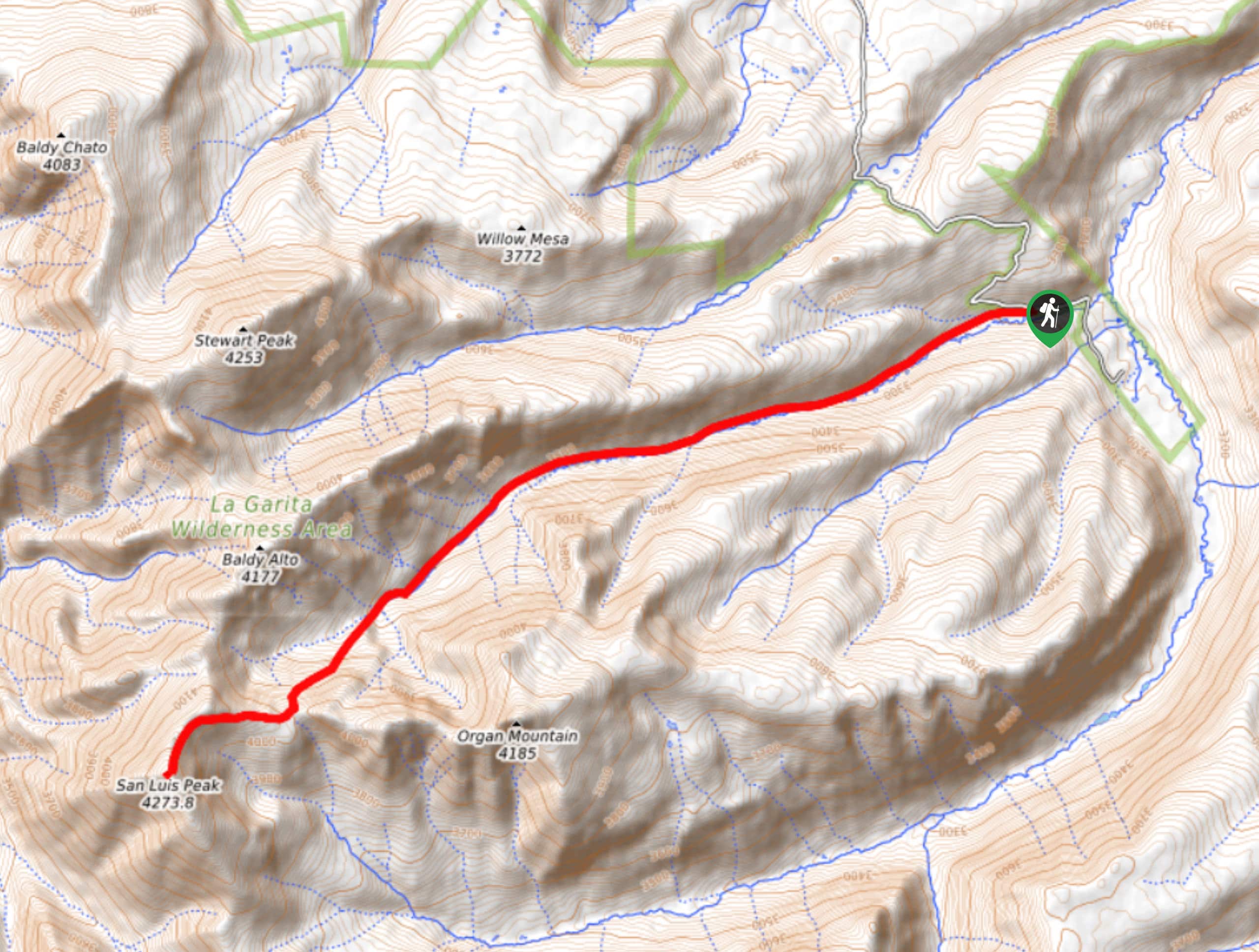
San Luis Peak via Stewart Creek Trail
View Photos
San Luis Peak via Stewart Creek Trail
Difficulty Rating:
Hiking to San Luis Peak via Stewart Creek Trail is a well-maintained and challenging route that will lead you up to the summit of a fourteener in the San Juan Mountains. While out on the trail, you will make a long and gradual ascent through Stewart Gulch, before the final push up to the summit of San Luis for incredible views of the surrounding landscape. Make sure to keep an eye out for wildlife, including moose that are often spotted in the area!
Getting there
The starting point for the San Luis Peak via Stewart Creek Trail can be found at the Stewart Creek Trailhead on County Road 14DD.

About
| Backcountry Campground | No |
| When to do | June-September |
| Pets allowed | No |
| Family friendly | No |
| Route Signage | Average |
| Crowd Levels | Moderate |
| Route Type | Out and back |
San Luis Peak via Stewart Creek Trail
Elevation Graph
Weather
San Luis Peak via Stewart Creek Trail Description
Although it is geared towards more experienced hikers, the San Luis Peak via Stewart Creek Trail is one of the easier and more accessible routes that lead up to a fourteener in the San Luis Mountains. Featuring breathtaking alpine views and 3454ft of elevation gain, this route will certainly get your heartrate up in more ways than one!
Setting out from the parking area, you will follow the trail to the southwest as it runs parallel to the banks of Stewart Creek. Here, you will continue along the water’s edge and gradually climb uphill through Stewart Gulch, taking some time to enjoy the beautiful mountain views as you work your way towards San Luis Peak.
Eventually, the trail will turn more to the south and steepen, turning back to the southwest as it takes you on the final rugged ascent of San Luis Peak. After reaching the summit at 14002ft, you will be inundated with spectacular views that sweep across the San Juan Mountains and the rest of Colorado further afield. Once you have taken in the views, carefully make your way back down the same trail on the return to the trailhead.
Similar hikes to the San Luis Peak via Stewart Creek Trail hike

Twin Buttes and Lightner Creek Loop Trail
The Twin Buttes and Lightner Creek Loop Trail is a great hiking route in Durango, Colorado that features some challenging…

Meadow Loop via Horse Gulch Trail
The Meadow Loop via Horse Gulch Trail is a great hiking route in Durango that will take you uphill for…

The Ridge Trail
The Ridge Trail - also known as Raiders Ridge Trail - is an amazing hiking route in Durango, Colorado that…
Comments