Priest Gulch and Highline Driveway Loop Trail
View Photos
Priest Gulch and Highline Driveway Loop Trail
Difficulty Rating:
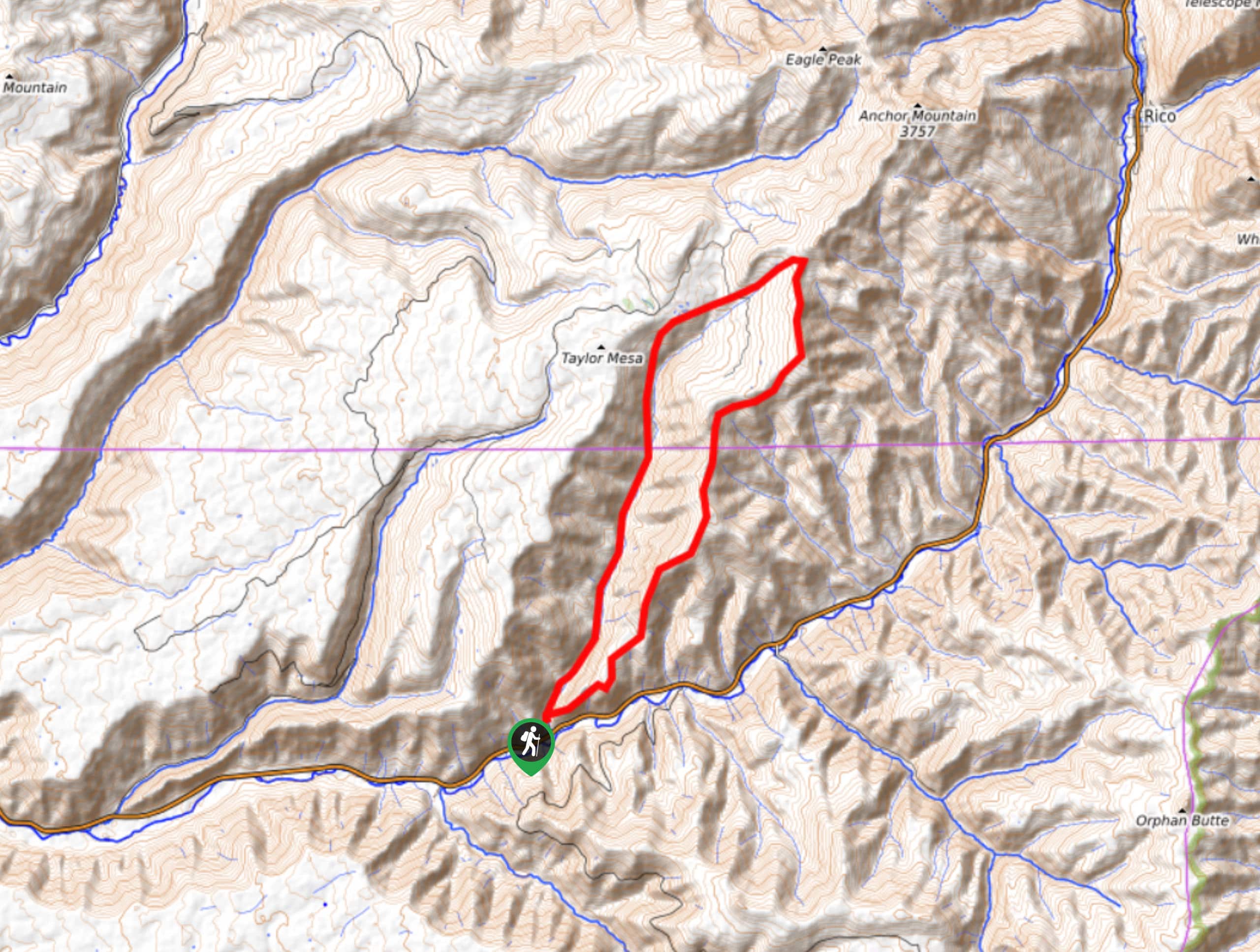
The Priest Gulch and Highline Driveway Loop Trail is a lengthy and challenging adventure in the San Juan Mountains of Colorado that will lead you through some rough and rugged terrain. While out hiking the trail, you will climb uphill through a forested gulch to reach a picturesque meadow, before looping back along a wooded ridge to the trailhead. This is a long and arduous walk, so be sure to wear appropriate footwear and bring plenty of water.
Getting there
The starting point for the Priest Gulch and Highline Driveway Loop Trail can be found along Priest Gulch Road, near the junction with CO-145.

About
| Backcountry Campground | No |
| When to do | July-September |
| Pets allowed | Yes - On Leash |
| Family friendly | No |
| Route Signage | Average |
| Crowd Levels | Low |
| Route Type | Circuit |
Priest Gulch and Highline Driveway Loop Trail
Elevation Graph
Weather
Priest Gulch and Highline Driveway Loop Trail Description
Hiking the Priest Gulch and Highline Driveway Loop Trail may be a difficult undertaking, but the lovely woodland views and sense of accomplishment at having completed a 15.6mi hike will certainly be enough of a reward. This adventure will take up a large portion of your day, so be sure to plan your trip accordingly and start early in the morning.
Setting out from the parking area, you will make your way to the northeast along the footpath as it traverses a small meadow and enters into the forest. Here, you will begin the long and gradual uphill climb through the forested gulch, following along the banks of a stream as you traverse the rugged landscape. The elevation gain along this route is a fairly large 3927ft, so make sure to take your time and stop for plenty of water breaks.
After climbing uphill through the gulch, you will come to a peaceful meadow which offers a relaxing place to sit and rest for a while. From this point, you will follow the trail as it turns to the southwest and begins descending through a mixture of woodland terrain and meadows along a ridge. After traversing the rugged landscape here and enjoying the views, you will eventually make the final descent along a wide switchback to return to the trailhead.
Similar hikes to the Priest Gulch and Highline Driveway Loop Trail hike

Twin Buttes and Lightner Creek Loop Trail
The Twin Buttes and Lightner Creek Loop Trail is a great hiking route in Durango, Colorado that features some challenging…

Meadow Loop via Horse Gulch Trail
The Meadow Loop via Horse Gulch Trail is a great hiking route in Durango that will take you uphill for…

The Ridge Trail
The Ridge Trail - also known as Raiders Ridge Trail - is an amazing hiking route in Durango, Colorado that…
Comments