Mount Eolus Hike
View Photos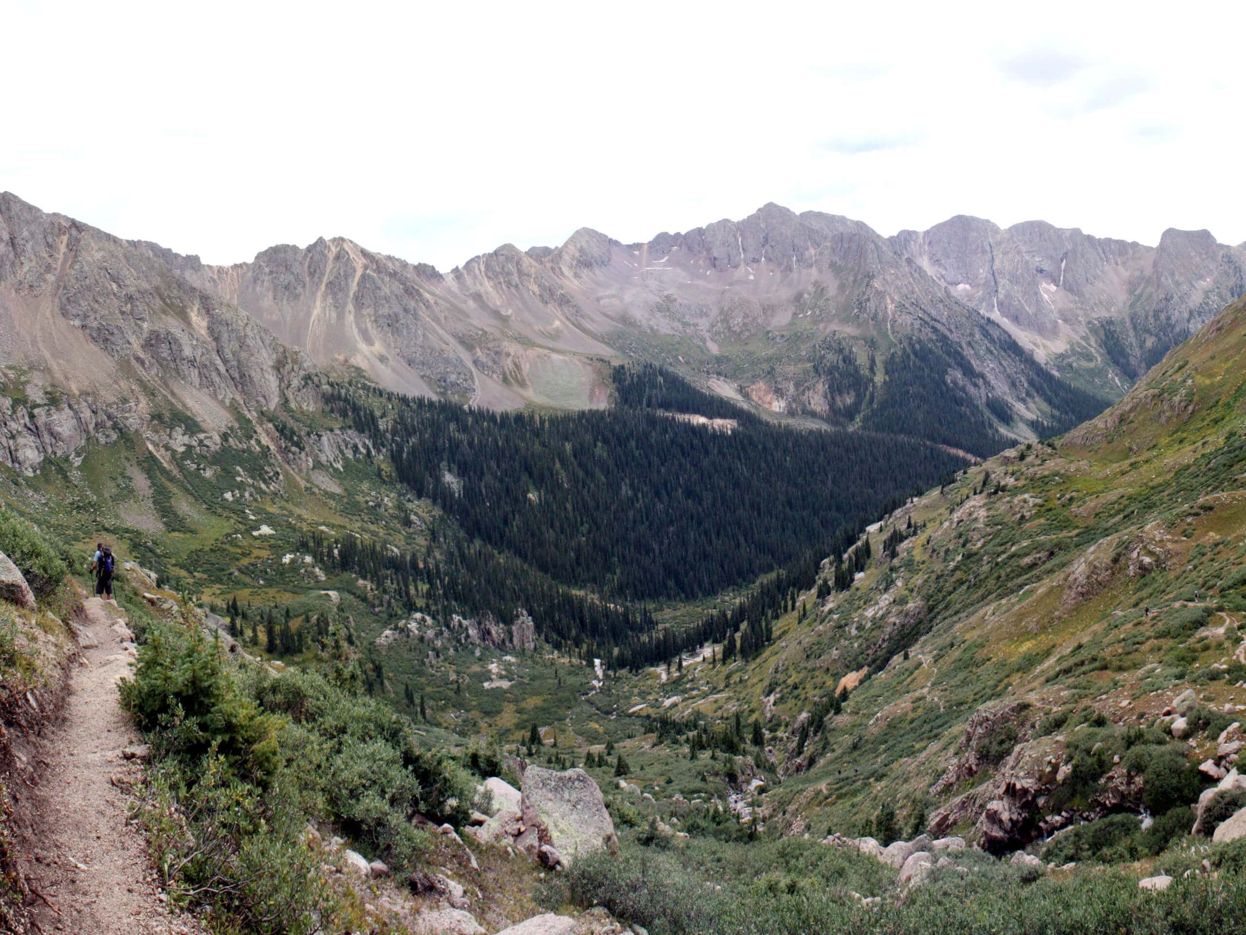
Mount Eolus Hike
Difficulty Rating:
The Mount Eolus Hike is a very challenging adventure in the Rocky Mountains that will take you to the summit of a rugged fourteener, making it suitable only for experienced hikers. While out on the trail, you will traverse the vast Chicago Basin and climb up to the Twin Lakes, before pushing on to the rocky summit of Mount Eolus for incredible views of the surrounding landscape. This is a long and difficult hike that will certainly take a full day, so make sure to plan your adventure out well in advance.
Getting there
The trailhead for the Mount Eolus Hike can be found at the Needleton Flagstop along the Durango & Silverton Narrow Gauge Railroad.

About
| Backcountry Campground | Chicago Basin |
| When to do | July-September |
| Pets allowed | Yes |
| Family friendly | No |
| Route Signage | Average |
| Crowd Levels | Moderate |
| Route Type | Out and back |
Mount Eolus Hike
Elevation Graph
Weather
Mount Eolus Hike Description
The steep, rugged, and exposed terrain on the way to the summit of Mount Eolus is not suitable for anyone other than experienced hikers who are comfortable with traversing this type of terrain. Be sure to plan your hike well in advance, bring any necessary gear/supplies, and always check for weather conditions before setting out. You should also remember to bring bear spray along for this hike and exercise all precautions when hiking through the Chicago Basin.
Although it is certainly one of the more challenging adventures in the area, hiking up Mount Eolus is a stimulating and breathtaking experience that will provide some of the most beautiful views overlooking the surrounding alpine terrain. Some very physically fit hikers will be able to complete this route in a single day, but you can also turn it into an amazing multi-day excursion with a night spent out in the mountains!
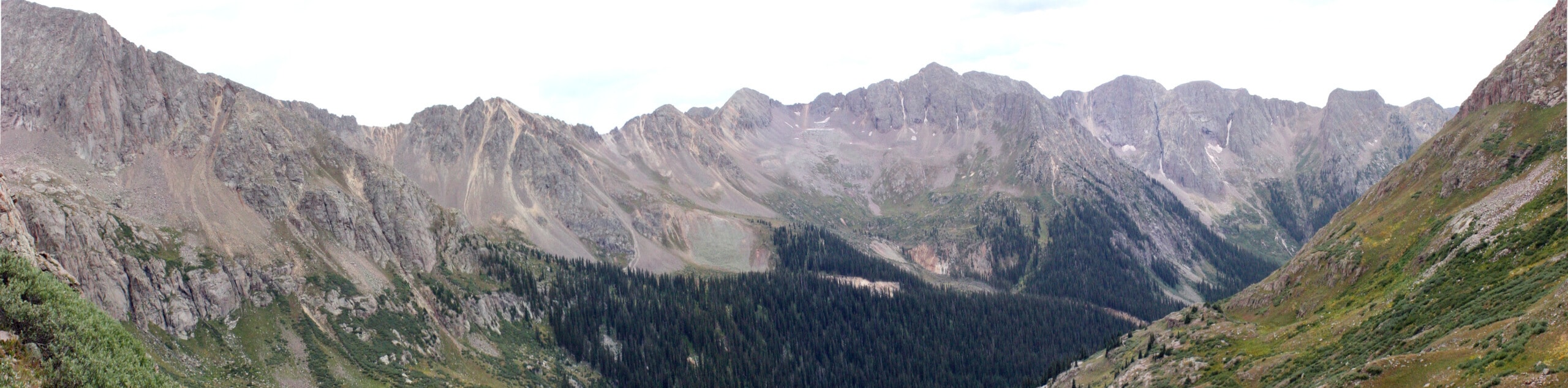
Setting out from the trailhead at the Needleton Flagstop, you will make your way to the southwest along the trail for 0.9mi, before arriving at a junction near the banks of Needle Creek. Here, you will keep to the left and follow closely alongside the winding banks of the creek as it leads you to the southeast and into the vast expanse of the Chicago Basin.
Climbing uphill to the southeast over the next 4.2mi, you will have plenty of time to relax amongst your woodland surroundings and reconnect with the beauty of the natural world. Eventually, you will break free of the tree cover and pass through some lovely meadows, follow the trail as it bends to the north over the next 1.6mi to arrive at another fork.
Heading left here, the trail will steepen considerably and lead you across some rugged terrain for 1.1mi to eventually bring you to the scenic alpine shores of the Twin Lakes. This is a great place to pause for a quick rest and to take in the natural beauty of the alpine landscape, before heading left at the junction for the ascent of Mount Eolus.
Making your way to the west, you will carefully climb up the wild and rocky slopes of the mountain for 1.1mi, where you will arrive at a junction in the trail at a point between the summit of Mount Eolus and the sub-peak of North Eolus.
Heading left here, you will need to traverse an exhilarating and very exposed stretch of trail that is classified as a class 3 climb, so if you are not an experienced climber and are uncomfortable with exposed routes, you should not attempt to summit Mount Eolus. For those who do push on to the summit, you will be rewarded with breathtaking views overlooking the entire Chicago Basin and back to the east across the Sunlight and Windom peaks.
After taking in the amazing alpine scenery, you will need to carefully make your way back through the rugged mountain terrain to once again reach the shores of the Twin lakes. From here, simply follow the same route back through the basin in order to wrap up your time on the Mount Eolus Hike.
Trail Highlights
Sunlight Peak
At 14065ft, Sunlight Peak is one of three fourteeners in the Needle sub-range of the Rocky Mountains, alongside Windom Peak and Mount Eolus. This mountain is fairly remote and is surrounded by a wild landscape, including a number of rugged peaks, the wonderfully scenic Twin Lakes, and the Chicago Basin.
Mount Eolus
Along with Sunlight Peak and Windom Peak, Mount Eolus is one of three fourteeners in the Needle sub-range of the Rocky Mountains. Characterized by a wild and rugged landscape, these peaks form the cirque known as the Upper Chicago Basin, with Mount Eolus located at the western end. At 14090ft Mount Eolus is close to – if not taller than Windom Peak – which would make it the tallest mountain in the Needle sub-range.
Frequently Asked Questions
How do I reach the Chicago Basin?
In order to access the Chicago Basin, you will take the Durango & Silverton Narrow Gauge Railroad, making sure to get off at the Needleton Flagstop.
Will I need a permit to hike in the Chicago Basin?
Currently there are no permits required for hiking in the Chicago Basin.
Insider Hints
Wear sturdy hiking boots with good ankle support for this rugged adventure.
This is a lengthy hike, so make sure to bring plenty of water and snacks.
Don’t forget the bug repellent, as there will be plenty of flies and bugs along the trail!
Bear spray is also needed if you are planning on hiking this route.
Similar hikes to the Mount Eolus Hike hike

Twin Buttes and Lightner Creek Loop Trail
The Twin Buttes and Lightner Creek Loop Trail is a great hiking route in Durango, Colorado that features some challenging…

Meadow Loop via Horse Gulch Trail
The Meadow Loop via Horse Gulch Trail is a great hiking route in Durango that will take you uphill for…

The Ridge Trail
The Ridge Trail - also known as Raiders Ridge Trail - is an amazing hiking route in Durango, Colorado that…
Comments