
Haflin Creek Hike
View Photos
Haflin Creek Hike
Difficulty Rating:
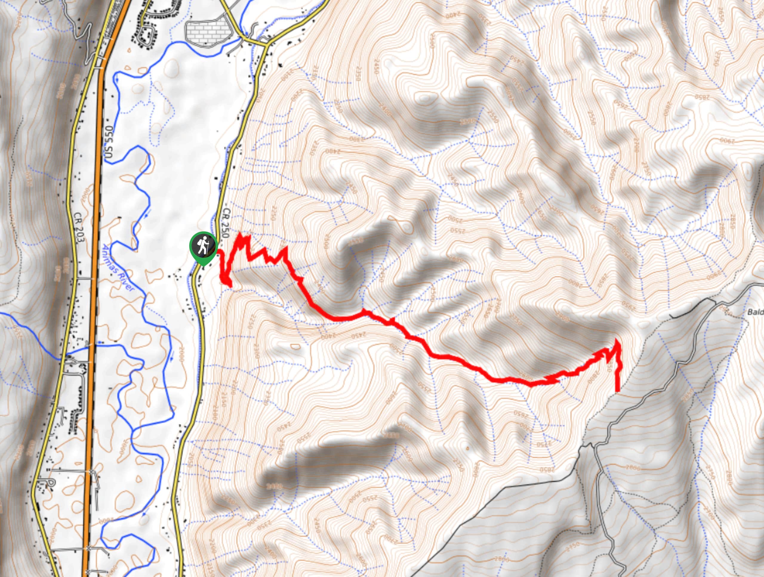
The Haflin Creek Hike is a tough excursion near Durango, Colorado that features plenty of steep terrain and beautifully scenic views. While out hiking the trail, you will climb uphill along a series of switchbacks through Haflin Canyon, gaining a good amount of elevation for some incredible views of the surrounding San Juan Mountains and the Animas River Valley. The route may be tough, but the stunning views are a great reward for your effort.
Getting there
The trailhead for the Haflin Creek Hike can be found along County Road 250 at the Haflin Canyon parking area, just 5.2mi north of Durango.

About
| Backcountry Campground | No |
| When to do | March-November |
| Pets allowed | Yes |
| Family friendly | No |
| Route Signage | Average |
| Crowd Levels | Moderate |
| Route Type | Out and back |
Haflin Creek Hike
Elevation Graph
Weather
Haflin Creek Hike
Featuring gorgeous views of the surrounding San Juan Mountains, the Haflin Creek Hike is a great option if you are based in the Durango area and want to push yourself on a challenging route with fairly steep inclines along the trail.
Setting out from the trailhead, you will head to the southeast through the tree cover and into the rocky landscape of Haflin Canyon. Here, you will turn back to the north and begin climbing uphill, working your way through a series of steep switchbacks that will see you gain a lot of elevation above the canyon.
After working your way uphill along the banks of Haflin Creek and taking in the beautiful views of the canyon landscape surrounding you, you will make the final push uphill to the endpoint of the route at the junction with the Missionary Ridge Trail. Once you have taken in the views, carefully work your way back through the canyon along the same route to return to the trailhead.
Similar hikes to the Haflin Creek Hike hike

Twin Buttes and Lightner Creek Loop Trail
The Twin Buttes and Lightner Creek Loop Trail is a great hiking route in Durango, Colorado that features some challenging…

Meadow Loop via Horse Gulch Trail
The Meadow Loop via Horse Gulch Trail is a great hiking route in Durango that will take you uphill for…

The Ridge Trail
The Ridge Trail - also known as Raiders Ridge Trail - is an amazing hiking route in Durango, Colorado that…
Comments