
Bullion King Lake Road Hike
View Photos
Bullion King Lake Road Hike
Difficulty Rating:
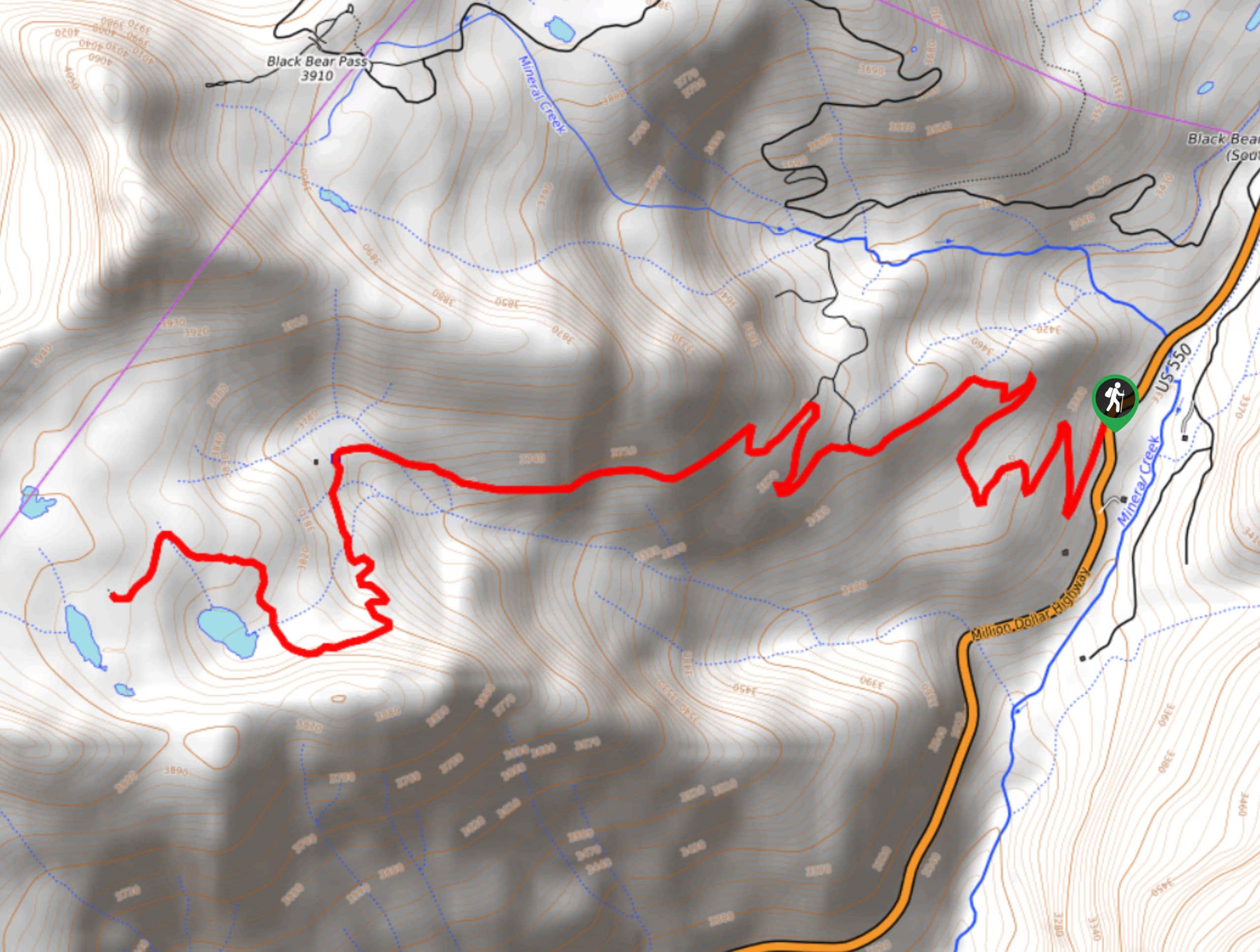
The Bullion King Lake Road Hike is a laidback hiking adventure in the mountains that will take you uphill along an off-road vehicle trail. While out hiking this route, you will follow the rough and rugged road as it winds up the mountainside, offering picturesque views of the surrounding mountain peaks before arriving at the shores of Bullion King Lake. As this hike does follow along an off-road vehicle route, be sure to keep an eye out for passing vehicles and allow them enough room to safely maneuver.
Getting there
The trailhead for the Bullion King Lake Road Hike can be found at the Porphyry Gulch Trailhead, at the junction of US-550 and Forest Service Road 822.

About
| Backcountry Campground | No |
| When to do | July-October |
| Pets allowed | Yes |
| Family friendly | Older Children only |
| Route Signage | Average |
| Crowd Levels | Moderate |
| Route Type | Out and back |
Bullion King Lake Road Hike
Elevation Graph
Weather
Bullion King Lake Road Hike Description
While it isn’t the most challenging of hiking routes in the San Juan Mountains, the Bullion King Lake Road Hike is a scenic adventure that will be sure to get your heartrate up a bit while experiencing the gorgeous views of the surrounding Colorado wilderness.
Setting out from the trailhead, you will follow along the road as it winds up the mountainside in a western direction. Here, you will traverse the wide switchbacks along the road while taking in the views of the surrounding meadows, sparsely populated forests, and mountain peaks.
Keeping left along the road, you will eventually pass by some old mining ruins and make the final push up to the scenic shores of Bullion King Lake. Take some time here to explore the area, breathe the fresh mountain air, and soak up the scenery, before carefully heading back along the same route to return to the trailhead.
Similar hikes to the Bullion King Lake Road Hike hike

Twin Buttes and Lightner Creek Loop Trail
The Twin Buttes and Lightner Creek Loop Trail is a great hiking route in Durango, Colorado that features some challenging…

Meadow Loop via Horse Gulch Trail
The Meadow Loop via Horse Gulch Trail is a great hiking route in Durango that will take you uphill for…

The Ridge Trail
The Ridge Trail - also known as Raiders Ridge Trail - is an amazing hiking route in Durango, Colorado that…
Comments