Moon Ridge Trail to Bow Canyon Loop
View Photos
Moon Ridge Trail to Bow Canyon Loop
Difficulty Rating:
The Moon Ridge Trail to Bow Canyon Loop is a short but fun hiking route in the San Bernardino National Forest that offers beautiful views of the surrounding area. While out on the trail, you will climb uphill through the forest to the top of Moon Ridge, where you will enjoy a sightline out to the Big Bear and Baldwin lakes. Be sure to arrive prepared for your hike and have your adventure Pass displayed in your vehicle prior to setting out.
Getting there
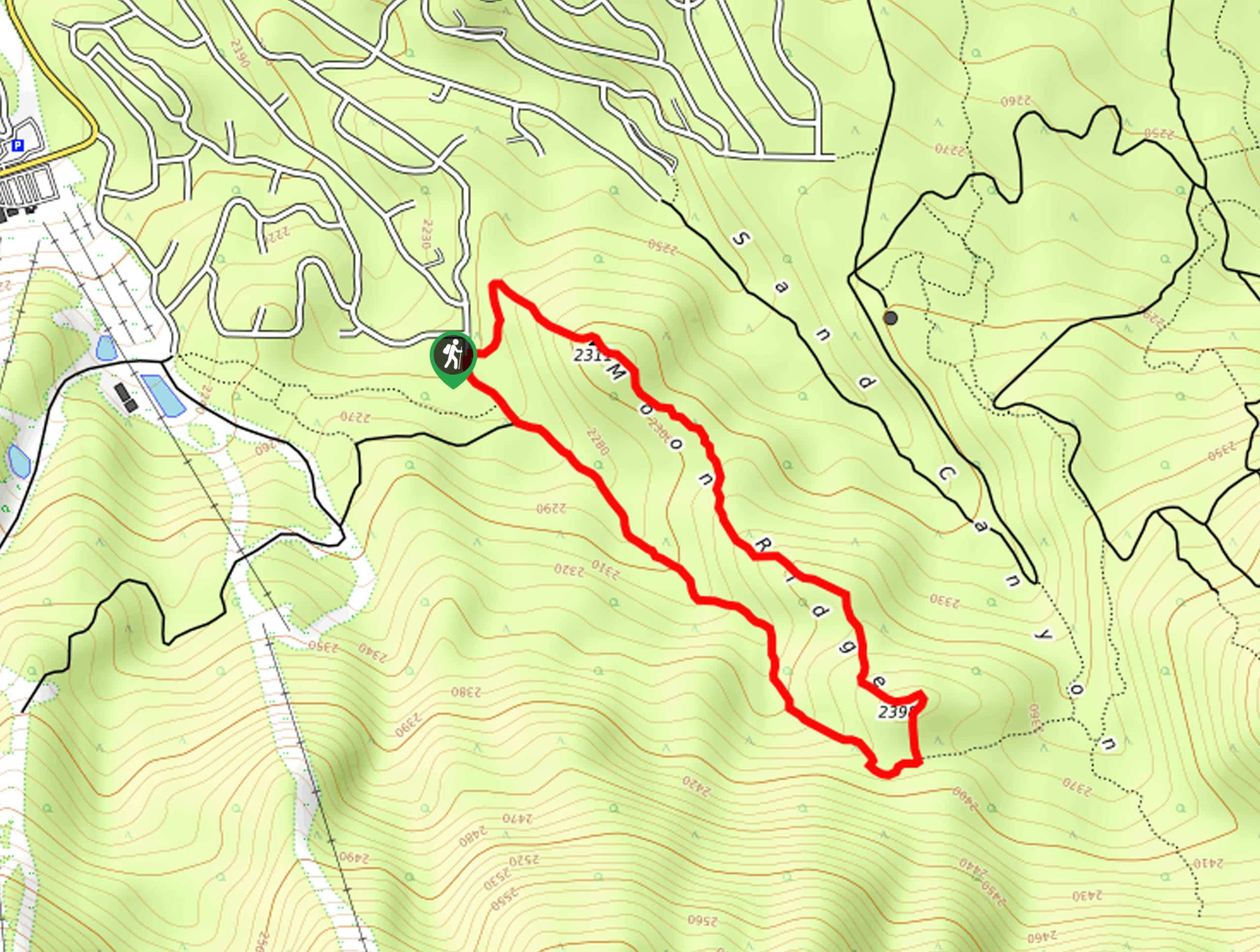
The trailhead for the Moon Ridge Trail to Bow Canyon Loop can be found at the end of Ridgecrest Drive, just 1.0mi southeast of the Bear Mountain Golf Course.

About
| Backcountry Campground | No |
| When to do | April-November |
| Pets allowed | Yes - On Leash |
| Family friendly | Yes |
| Route Signage | Average |
| Crowd Levels | Moderate |
| Route Type | Circuit |
Moon Ridge Trail to Bow Canyon Loop
Elevation Graph
Weather
Moon Ridge Trail to Bow Canyon Loop Description
If you are after a quick adventure near San Bernardino that offers some pretty amazing views for minimal effort, then the Moon Ridge Trail to Bow Canyon Loop will be a great option for you to explore the beauty of Southern California.
The route begins at the end of Ridgecrest Drive and will initially see you gain elevation through the forest to the northeast, before turning to the southwest as you climb up the ridge. From here, you will enjoy some lovely views of the surrounding landscape, before descending and looping around to the northwest through the forest on the return leg of the hike.
Similar hikes to the Moon Ridge Trail to Bow Canyon Loop hike

Bluff Mesa Hike
The Bluff Mesa Hike is a fantastic adventure in Southern California that features a lovely woodland setting and can be…

Palm View Peak Trail
The Palm View Peak Trail is a great hiking route in the San Bernardino National Forest that features a solid…

Cram Peak Ridge Trail
The Cram Peak Ridge Trail is a fantastic, albeit difficult, hiking route in the San Bernardino National Forest that will…
Comments