Cloudland Truck Trail
View Photos
Cloudland Truck Trail
Difficulty Rating:
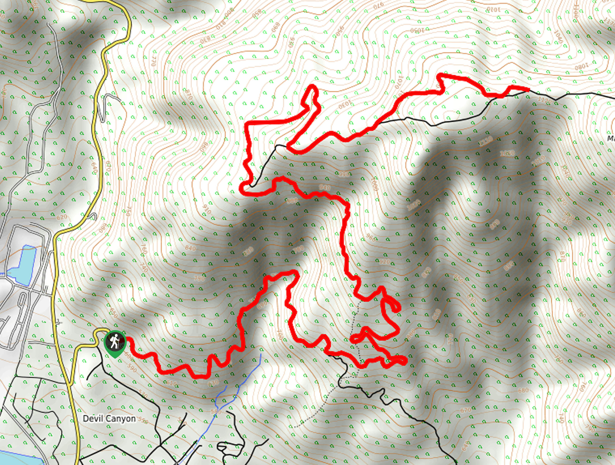
The Cloudland Truck Trail is a great hiking route in San Bernardino, California that will take you on a steady climb with views of the surrounding landscape. While out hiking the trail, you will follow along the dirt road as it winds up the slopes of Marshall Peak to provide views overlooking San Bernardino and nearby peaks. Hikers should take note that this is a multi-use trail that is shared with off-highway vehicles, so make sure to exercise all precautions and allow vehicles enough room to maneuver.
Getting there
The starting point for the Cloudland Truck Trail can be found off Devils Canyon Road, just north of the California State University Campus in San Bernardino.

About
| Backcountry Campground | No |
| When to do | Year-Round |
| Pets allowed | Yes - On Leash |
| Family friendly | Older Children only |
| Route Signage | Average |
| Crowd Levels | Moderate |
| Route Type | Out and back |
Cloudland Truck Trail
Elevation Graph
Weather
Cloudland Truck Trail Description
For those who want a straightforward hiking adventure in San Bernardino that will offer some pretty views and a solid leg burn thanks to the steady uphill climb, the Cloudland Truck Trail is a fantastic option to explore.
Setting out from the trailhead, you will make your way east on the road and follow it as it winds along the hillside, before turning to the northeast to gain elevation. As you steadily work your way uphill, the views looking back over San Bernardino to the south will become even more scenic.
After working your way up the winding mountain road, the route will turn back to the east for the final push up to the top of Marshall Peak. While this route stops short of the summit, feel free to continue on along the road to extend the length of your hike. From the end of the trail the easy part of the hike begins, as you make a leisurely descent along the road and take in the sprawling views before you.
Similar hikes to the Cloudland Truck Trail hike

Bluff Mesa Hike
The Bluff Mesa Hike is a fantastic adventure in Southern California that features a lovely woodland setting and can be…

Palm View Peak Trail
The Palm View Peak Trail is a great hiking route in the San Bernardino National Forest that features a solid…

Cram Peak Ridge Trail
The Cram Peak Ridge Trail is a fantastic, albeit difficult, hiking route in the San Bernardino National Forest that will…
Comments