
Camp Seely to Cedarpines Park Loop Trail
View Photos
Camp Seely to Cedarpines Park Loop Trail
Difficulty Rating:
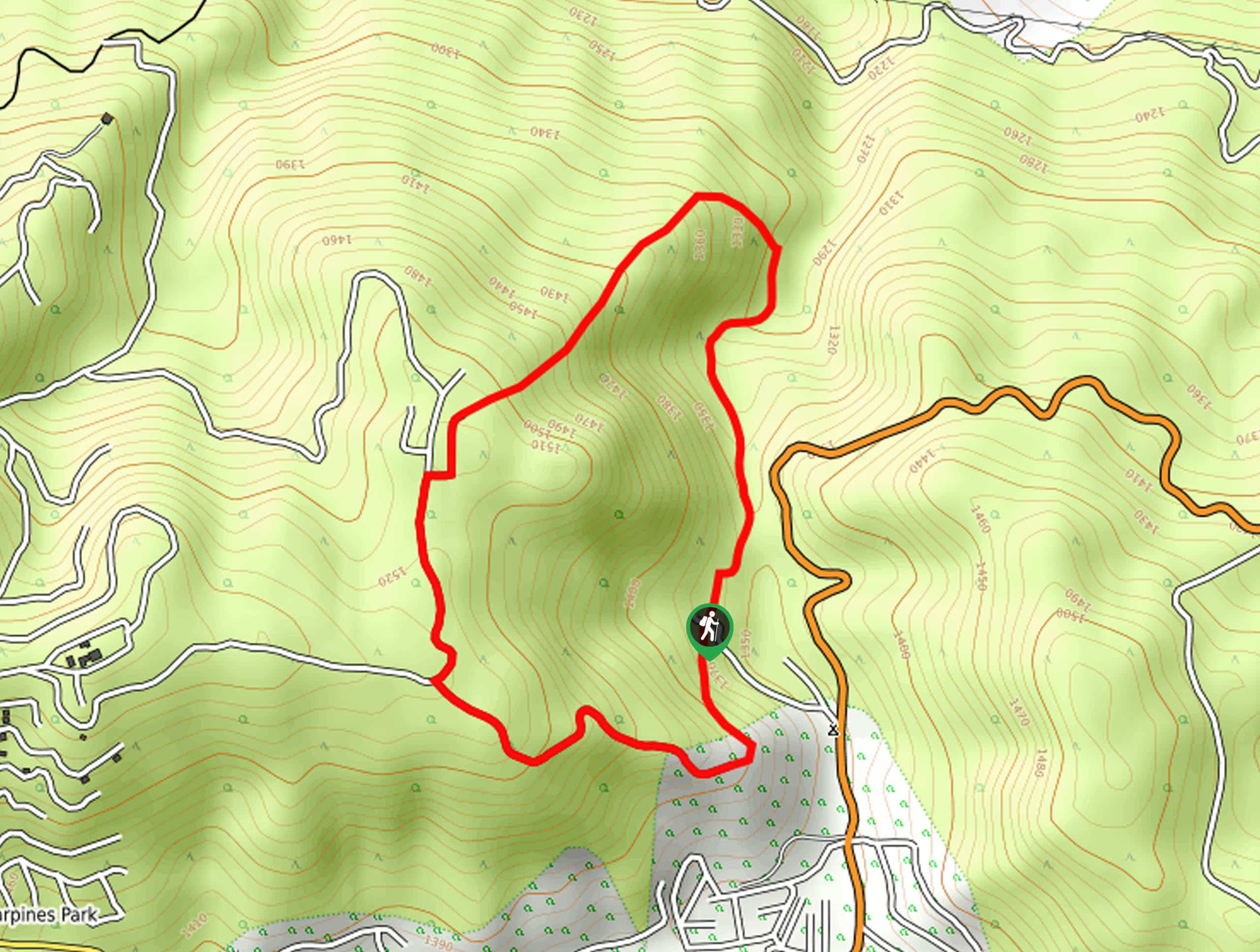
The Camp Seely to Cedarpines Park Loop Trail is a short adventure in San Bernardino National Forest that offers scenic views overlooking the Valley of Enchantment. While out on the trail, you will climb uphill through the forest and loop around to a lookout with sweeping views of the surrounding landscape, before descending into the trailhead. This is a fun hiking route that the entire family can enjoy, just be prepared to break a bit of a sweat!
Getting there
The starting point for the Camp Seely to Cedarpines Park Loop Trail can be found near Camp Seely along CA-138.

About
| Backcountry Campground | Camp Seely |
| When to do | March-November |
| Pets allowed | Yes - On Leash |
| Family friendly | Yes |
| Route Signage | Average |
| Crowd Levels | Low |
| Route Type | Circuit |
Camp Seely to Cedarpines Park Loop Trail
Elevation Graph
Weather
Camp Seely to Cedarpines Park Loop Trail Description
The Camp Seely to Cedarpines Park Loop Trail is a fantastic hiking route in the San Bernardino area that is a great alternative if you have already completed the Heart Rock Hike, as it begins from the same trailhead. This trail does feature a bit of an elevation, so be prepared for a good workout!
Setting out from the trailhead, you will follow along the paved service road as it leads to the north. After passing by the sewage treatment plant on your left, the trail will turn to the southwest and begin climbing more sharply uphill through the forest.
Eventually, you will meet up with Kissing Rock Road and follow it south and onto Mojave Rock Road. This will also lead to the south to a fork, at which point you will head left to arrive at a lookout with views over the Valley of Enchantment. From here, simply follow the road downhill to the east to arrive back at the trailhead.
Similar hikes to the Camp Seely to Cedarpines Park Loop Trail hike

Bluff Mesa Hike
The Bluff Mesa Hike is a fantastic adventure in Southern California that features a lovely woodland setting and can be…

Palm View Peak Trail
The Palm View Peak Trail is a great hiking route in the San Bernardino National Forest that features a solid…

Cram Peak Ridge Trail
The Cram Peak Ridge Trail is a fantastic, albeit difficult, hiking route in the San Bernardino National Forest that will…
Comments