
Spray Park Trail to Mount Pleasant
View Photos
Spray Park Trail to Mount Pleasant
Difficulty Rating:
Spray Park is the perfect starting point for a trek to Mount Pleasant, and this moderate out and back trail in Mount Rainier National Park is a great way to experience the classic beauty of Rainier—wildflowers, waterfalls, mountain peak—without the same level of traffic you’d find on similar trails in the park. With a bit of a challenge on switchbacks making you feel like you earned your views. A pit-stop at Spray Falls on the way to Mount Pleasant makes for a perfectly charming day out.
Getting there
To get to the trailhead for the hike up Spray Park Trail to Mount Pleasant from Wilkeson, drive south on State Route 165, keeping right at the Y-junction after you cross Carbon River. Drive for 17.0mi to Mowich Lake.

About
| Backcountry Campground | Mowich Lake |
| When to do | June-September |
| Pets allowed | No |
| Route Signage | Average |
| Crowd Levels | Moderate |
| Route Type | Out and back |
Spray Park Trail to Mount Pleasant
Elevation Graph
Weather
Spray Park Trail to Mount Pleasant Description
The hike to Mount Pleasant on Spray Park Trail is pleasant indeed, offering a moderate physical challenge in exchange for carpets upon carpets of wildflowers, Spray Falls, and the views from Mount Pleasant. You’ll need to work a bit harder on the switchbacks to the summit, but this hike offers no technical challenge and lighter crowds than many in the park, making it well worth it.
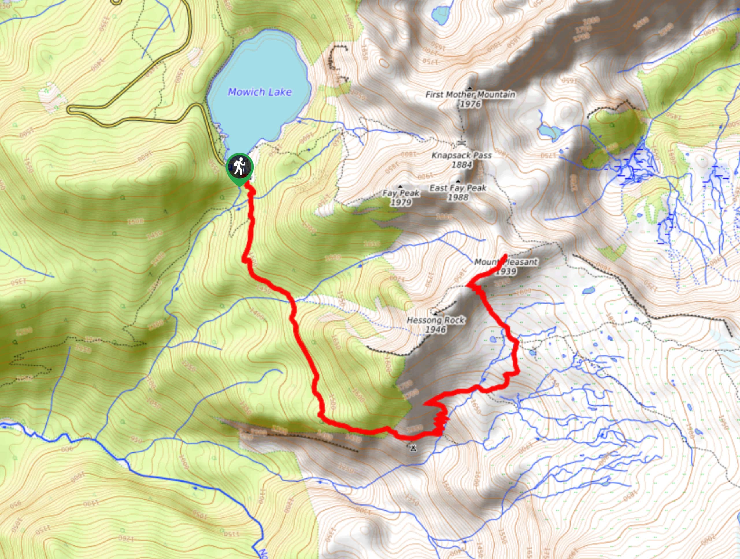
From the Mowich Lake campground, take the trailhead to the left of the facilities. You’ll be hiking on the Wonderland Trail for about three tenths of a mile, then keeping left onto the Spray Park Trail. Cross Lee Creek and continue on the obvious path.
Two viewpoints come along shortly after, the first being Eagle Cliff and the second Spray Falls. Both are on hiker’s right. Right after Spray Falls, the trail steeply switchbacks to gain elevation, then evens out a bit and crosses Grant Creek.
Just before re-crossing the creek, you’ll reach a junction. Keep left. Another creek crossing follows shortly thereafter. Take on a couple more (narrower) switchbacks, keeping to the right at a T-intersection where a trail leads to Hessong Rock on the left.
To the right is the final ascent to Mount Pleasant. From here, most hikers will retrace their steps to return, but you can continue to follow the ridgeline on Knapsack Pass Trail for a ways, perhaps even making a loop by rejoining Spray Park Trail and hiking southwest back to the junction at Grant Creek.
Insider Hints
The road to Mowich tends to get washboarded and potholed, so drive slowly and take a vehicle with at least moderate clearance.
The bugs can be bothersome on this trail, particularly in the Spray Park meadow. Bring lots of bug spray!
Parking at Mowich gets busy, so we recommend arriving early.
Similar hikes to the Spray Park Trail to Mount Pleasant hike

Paul Peak Trail
The Paul Peak Trail is a 6.3mi lightly trafficked out and back trail in Mount Rainier National Park…

Narada Falls to Mazama Ridge Loop
The Narada Falls to Mazama Ridge loop is an 7.4mi moderately trafficked route in Mount Rainier National Park…

Camp Summerland via Wonderland Trail
The hike to Camp Summerland on the Wonderland Trail is a 8.4mi moderately trafficked out and back trail…
Comments