
Panorama Point Hike
View Photos
Panorama Point Hike
Difficulty Rating:
The hike from Paradise Inn to Panorama Point is a popular choice in Mount Rainier National Park, and this moderately challenging hike is a favourite year-round for hikers and snowshoers alike. With a great view of Rainier and plenty of wildflowers lining the trail in the summertime, Panorama Points ends up on the to-do list of many hikers visiting Washington. If you only have a few hours to spare but you want to enjoy classic Rainier views without any technical challenge, this hike is the one.
Getting there
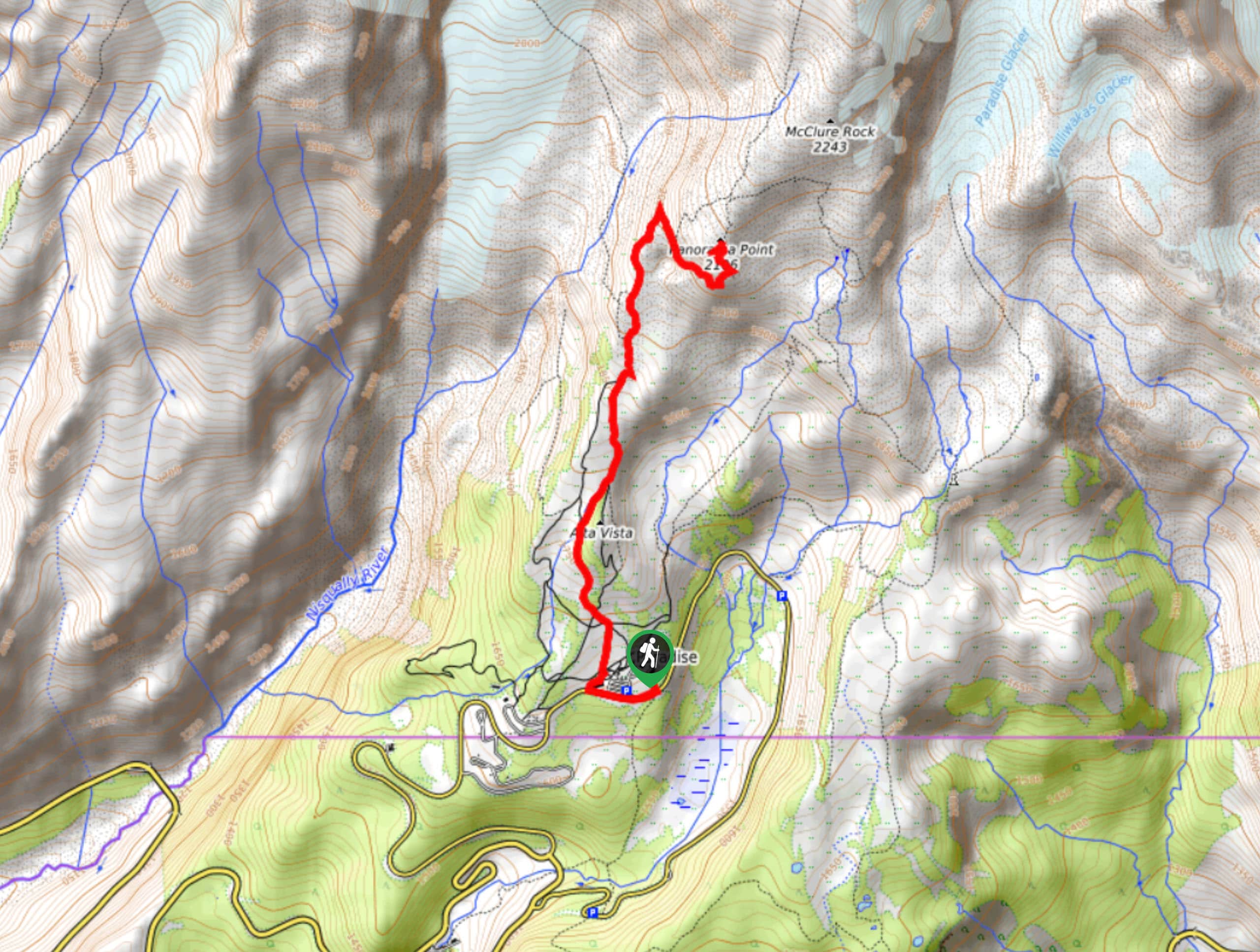
To get to the trailhead for the Panorama Point hike from the Nisqually entrance to the park, drive 17.0mi on State Route 706. Park at the lower lot at Paradise. If the lower lot is full, you can continue to the upper lot.

About
| Backcountry Campground | No |
| When to do | June-September |
| Pets allowed | No |
| Family friendly | Older Children only |
| Route Signage | Average |
| Crowd Levels | High |
| Route Type | Out and back |
Panorama Point Hike
Elevation Graph
Weather
Panorama Point Trail Description
The Panorama Point hike is a naturally beautiful hike that offers enough of a physical challenge to feel rewarding, but without any technical challenges. This trail is lined by wildflowers and has great views of Rainier, but this means it can get very busy. We recommend visiting early in the morning or later in the afternoon to avoid the heaviest crowds.
The trail starts from Paradise Inn. Take the trail that goes left from the inn past the parking lot. Walk past and behind the climbing information center, joining the Skyline Trail to head north. You’ll pass junctions with the Alta Vista Trail and the Waterfall Trail, and another arm of the Skyline Trail also veers right (northeast) in a loop. Pay attention to signage or a map.
The trail comes next to Dead Horse Creek, but stay right and do not cross the creek. Alta Vista stretches above to your right here. Further on, you’ll pass a junction with Dead Horse Creek Trail. Continue straight on. To more junctions come along, stay right at both, unless you want to make a quick detour to Glacier Vista, in which case you’ll take a left turn at the second junction and then rejoin the trail by retracing your steps.
The trail hairpins to head south. Keep right at the junction that comes next. When approaching Panorama Point, you first come to a viewpoint to hiker’s right. Feel free to stop here to admire Panorama Point, then continue up the trail through three switchbacks to the peak. From the summit, you’ll be able to see McClure Peak to the northeast, Mount Rainier and Anvil Rocks to the northwest, and Faraway Rock to the south.
From the peak, you can either retrace your steps or follow the trail that branches off to the north and then eventually east (hiker’s left) to hike Skyline in a loop. If you loop down Skyline, you can take Golden Gate Trail to see Golden Gate Falls, a nice extension.
Insider Hints
This trail is subject to heavy traffic, so we recommend hiking in off-peak hours.
Stay on the path and resist the urge to pick the lovely wildflowers to help protect the delicate ecosystem here.
Similar hikes to the Panorama Point Hike hike

Paul Peak Trail
The Paul Peak Trail is a 6.3mi lightly trafficked out and back trail in Mount Rainier National Park…

Narada Falls to Mazama Ridge Loop
The Narada Falls to Mazama Ridge loop is an 7.4mi moderately trafficked route in Mount Rainier National Park…

Camp Summerland via Wonderland Trail
The hike to Camp Summerland on the Wonderland Trail is a 8.4mi moderately trafficked out and back trail…
Comments