
Skyline and Golden Gate Loop
View Photos
Skyline and Golden Gate Loop
Difficulty Rating:
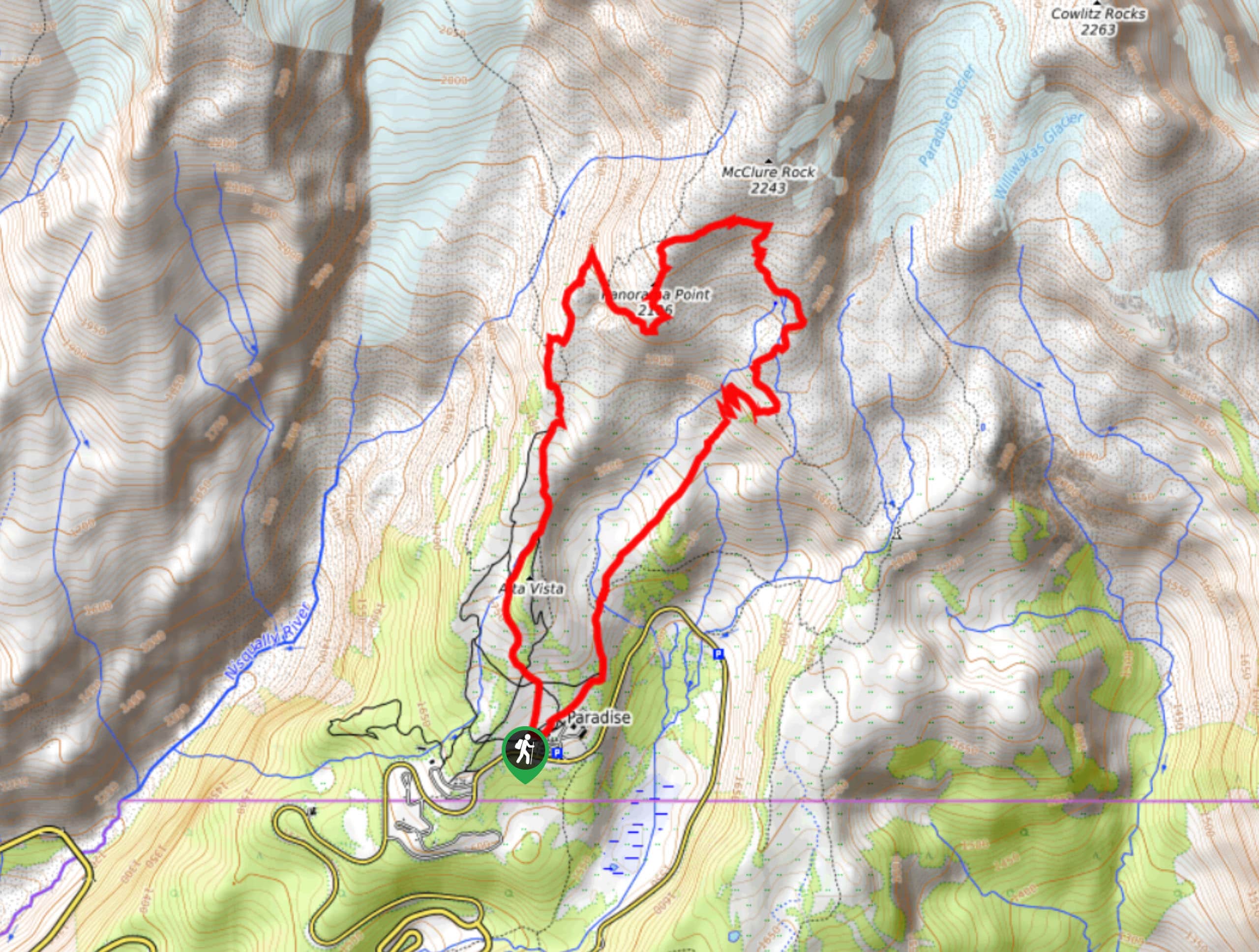
The Skyline and Golden Gate Loop trail is a 4.6mi moderately difficult trail in Mount Rainier National Park. This trail runs along Skyline to Glacier Vista, Upper Skyline, and Golden Gate. With expansive views to enjoy nearly the whole time, this is a great hike for those wanting maximum payoff without spending all day on the trail. Bring a map, as there are many intersecting trails on this loop.
Getting there
The trailhead for the Skyline and Golden Gate Loop is located in the upper Paradise parking area off Longmire-to-Paradise Road to the left of the restrooms.

About
| Backcountry Campground | No |
| When to do | July-October |
| Pets allowed | No |
| Family friendly | Older Children only |
| Route Signage | Average |
| Crowd Levels | High |
| Route Type | Loop |
Skyline and Golden Gate Loop
Elevation Graph
Weather
Skyline and Golden Gate Loop Description
The Skyline to Golden Gate Loop is a wonderful outing that offers great views of Mount Rainier and the Paradise region of Mount Rainier National Park. We recommend bringing GPS or a map on this hike due to the number of intersecting trails. There is also relatively little shade, so bring lots of water.
Begin in the Paradise visitors area, taking the Skyline Trail to the left of the restrooms. You can complete this loop either way, but we will describe it going clockwise. Take care to remain on Skyline through the first few intersections, eventually alongside Dead Horse Creek. At the Y-intersection with Glacier Vista, stay left to leave Skyline.
Hike to Glacier Vista, then go right at the junction with Skyline Trail. Follow Skyline to Panorama Point and then continue on as it eventually switchbacks down to become Golden Gate Trail. Pass Myrtle Falls and then stay left as you approach Paradise once again.
Similar hikes to the Skyline and Golden Gate Loop hike

Paul Peak Trail
The Paul Peak Trail is a 6.3mi lightly trafficked out and back trail in Mount Rainier National Park…

Narada Falls to Mazama Ridge Loop
The Narada Falls to Mazama Ridge loop is an 7.4mi moderately trafficked route in Mount Rainier National Park…

Camp Summerland via Wonderland Trail
The hike to Camp Summerland on the Wonderland Trail is a 8.4mi moderately trafficked out and back trail…
Comments