
Mazama Ridge Trail to Faraway Rock
View Photos
Mazama Ridge Trail to Faraway Rock
Difficulty Rating:
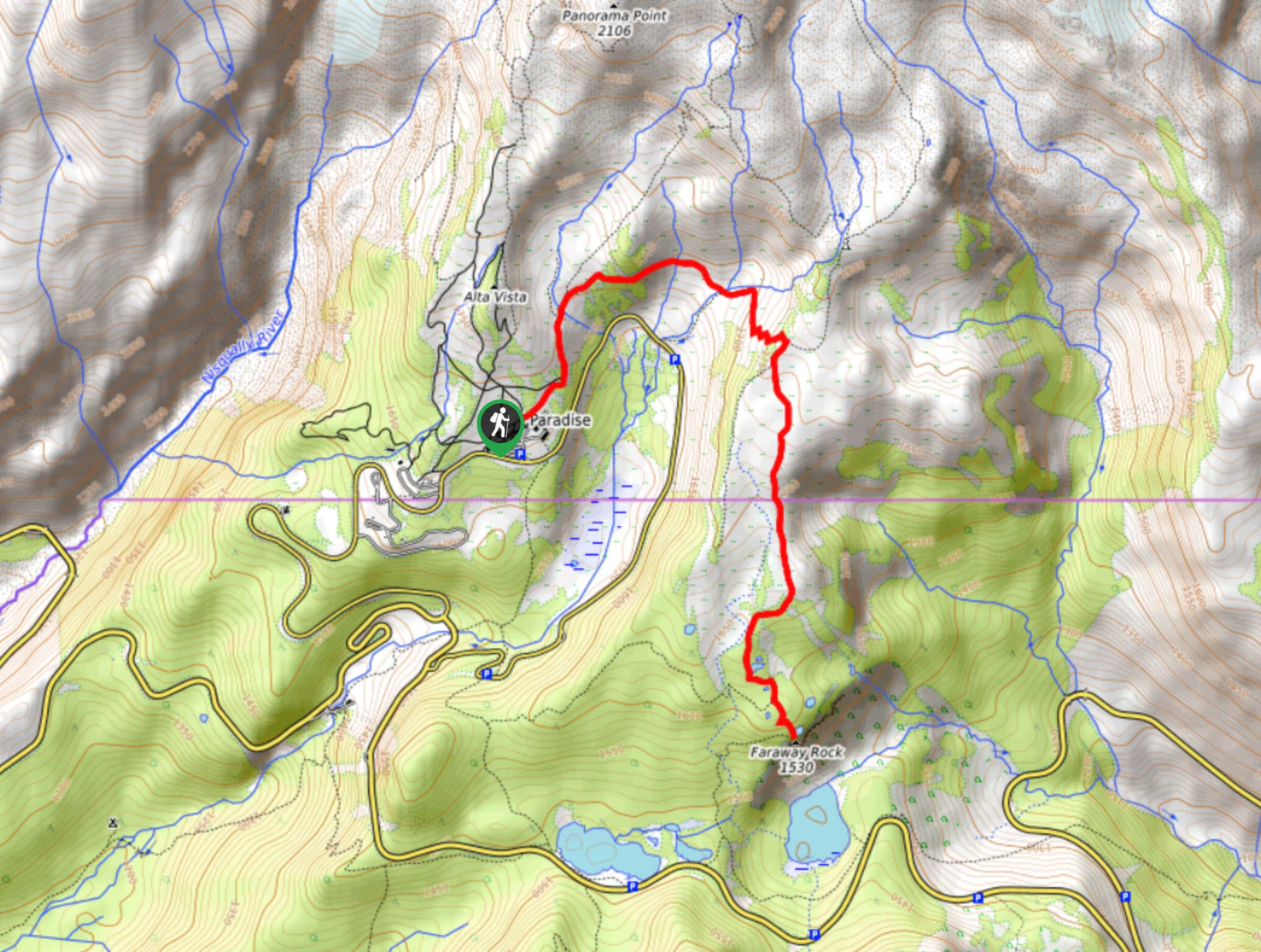
The Mazama Ridge Trail to Faraway Rock is a hard hike in Mount Rainier National Park that offers great views and light traffic. This trail traverses alpine meadows up to a ridge with breathtaking views. Follow the ridge to Faraway Rock, a steep little viewpoint that handsomely rewards your efforts to reach it. This is a fun trail with a high effort-reward payoff.
Getting there
To get to the trailhead for the Mazama Ridge Trail to Faraway Rock hike from the Nisqually entrance to the park, drive east on State Route 706, following the road to the Paradise Inn and parking here.

About
| Backcountry Campground | No |
| When to do | June-October |
| Pets allowed | No |
| Family friendly | No |
| Route Signage | Average |
| Crowd Levels | Moderate |
| Route Type | Out and back |
Mazama Ridge Trail to Faraway Rock
Elevation Graph
Weather
Mazama Ridge Trail to Faraway Rock Description
With laidback strolls through flower-filled meadows and steep, dizzying ascents to high viewpoints, the Mazama Ridge Trail to Faraway Rock hike is a diverse, fun trail that sees relatively little traffic. You’ll likely run into other hikers trailing through the Paradise area, but on your way up to Faraway Rock, expect to feel far away indeed.
This trail begins from the Paradise parking area. Head north out of the lot on the Skyline Trail. Cross Edith Creek above Myrtle Falls and head east across the valley. You’ll eventually come to a junction with the Skyline Trail heading off to the left and the Mazama Ridge Trail continuing straight; continue straight here.
The climb for the next half mile is steep, but you’ll crest the ridge soon. Once you do, admire the views of the Tatoosh Range and Mount Rainier. From atop the ridge, you’ll traverse south, surrounded by mountain vistas. As you approach Faraway Rock, you’ll skirt around several small lakes. The climb up to the rock is steep, so take your time. The viewpoint itself is also a bit precarious for some but focus on enjoying the stellar panorama in all directions.
Carefully make your way down from Faraway Rock and retrace your steps. There are plenty of opportunities to loop around the Skyline Trail if you’d like to extend your trip.
Similar hikes to the Mazama Ridge Trail to Faraway Rock hike

Paul Peak Trail
The Paul Peak Trail is a 6.3mi lightly trafficked out and back trail in Mount Rainier National Park…

Narada Falls to Mazama Ridge Loop
The Narada Falls to Mazama Ridge loop is an 7.4mi moderately trafficked route in Mount Rainier National Park…

Camp Summerland via Wonderland Trail
The hike to Camp Summerland on the Wonderland Trail is a 8.4mi moderately trafficked out and back trail…
Comments