
Golden Gate Trail
View Photos
Golden Gate Trail
Difficulty Rating:
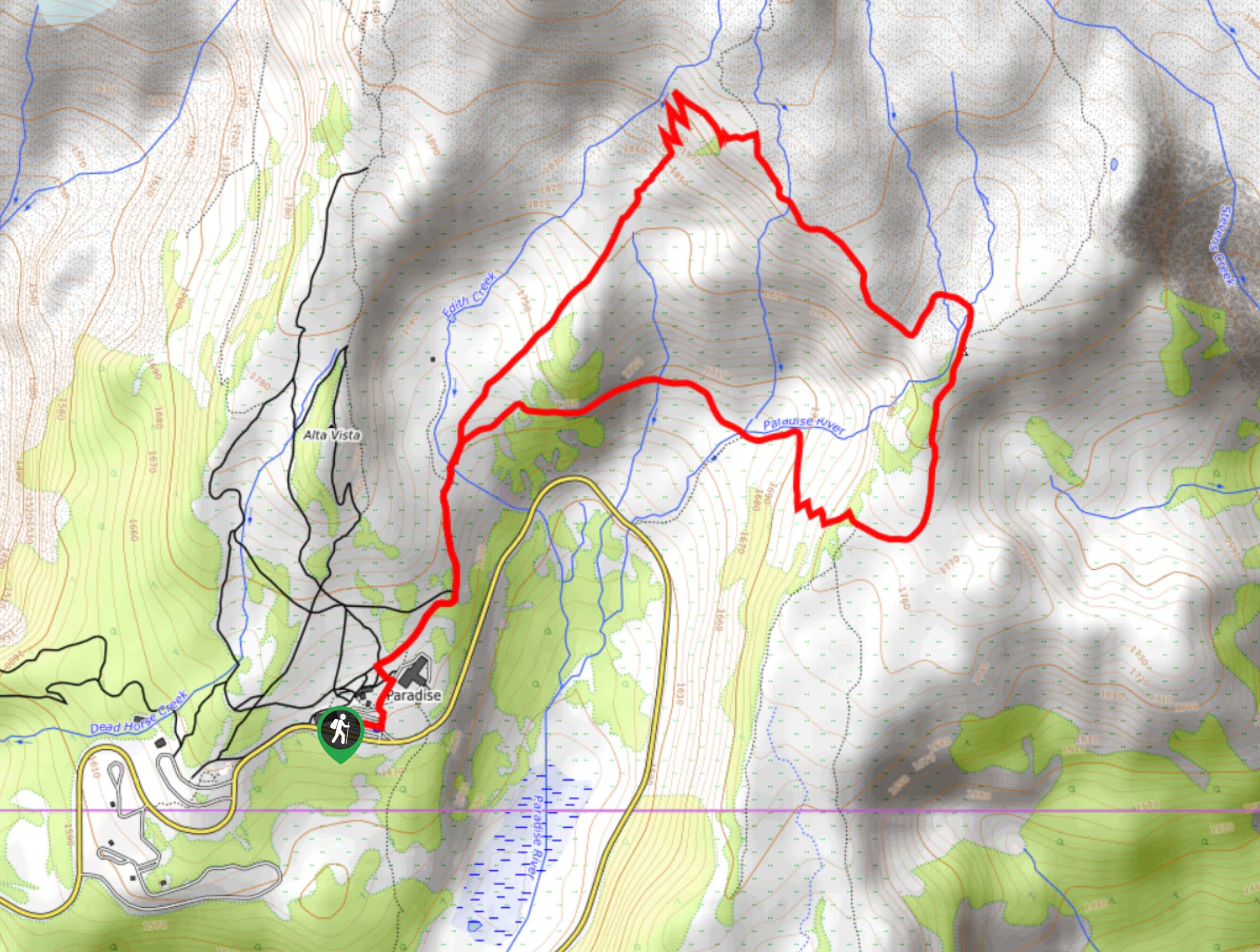
The Golden Gate Trail is a 3.8mi moderately difficult hike in Mount Rainier National Park that provides access to some fantastic photo spots. With tons of wildflowers to admire and perfect views of the Tatoosh Range and Mount Rainier, this hike offers a quintessential Rainier experience.
Getting there
To get to the trailhead for the Golden Gate Trail from the Nisqually entrance to the park, take Highway 706 east to the Paradise parking lot.

About
| Backcountry Campground | No |
| When to do | June-October |
| Pets allowed | No |
| Family friendly | Older Children only |
| Route Signage | Average |
| Crowd Levels | Moderate |
| Route Type | Lollipop |
Golden Gate Trail
Elevation Graph
Weather
Golden Gate Trail Description
With knockout wildflower meadows and a unique “golden gate” viewpoint at the junction with the Skyline Trail, the Golden Gate Trail is a fantastic moderate hike in Mount Rainier National Park. This trail offers the chance to extend your journey by looping around nearby trails if you want to.
From the Paradise Inn, taking the initially paved trail. This trail doesn’t stay paved for long, switchbacking up verdant slopes. Enjoy the view of the Tatoosh Range as you approach the “Golden gate” at the junction with Skyline. This is a perfect spot for some photos! Rainier, the range, the flowers, and the sky make for a gorgeous scene.
Most people call this their goal and retrace their steps back to the lot. If you’d prefer to extend your trip a bit, you can loop on the Skyline Trail in either direction.
Similar hikes to the Golden Gate Trail hike

Paul Peak Trail
The Paul Peak Trail is a 6.3mi lightly trafficked out and back trail in Mount Rainier National Park…

Narada Falls to Mazama Ridge Loop
The Narada Falls to Mazama Ridge loop is an 7.4mi moderately trafficked route in Mount Rainier National Park…

Camp Summerland via Wonderland Trail
The hike to Camp Summerland on the Wonderland Trail is a 8.4mi moderately trafficked out and back trail…
Comments