
High Lakes Trail
View Photos
High Lakes Trail
Difficulty Rating:
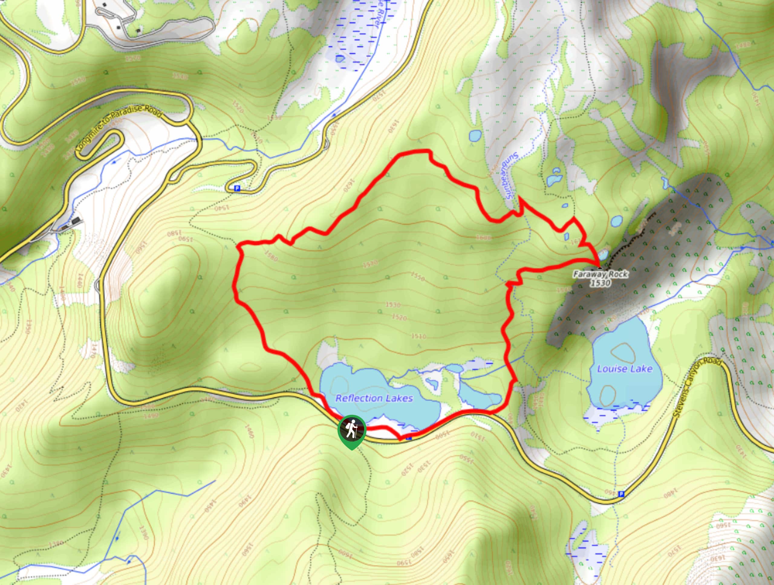
The High Lakes Trail is a 3.2mi loop in Mount Rainier National Park that is moderately difficult and offers pleasant views of seemingly countless lakes. This trail has some elevation change to contend with, but it’s great to enjoy with older children or novice hikers. Make sure you bring bug spray for this trail.
Getting there
The High Lakes Trail starts across the road from the Pinnacle Peak Trail Information Center on Stevens Canyon Road. You can park in the Reflection Lakes parking lot.

About
| Backcountry Campground | No |
| When to do | June-October |
| Pets allowed | No |
| Family friendly | Older Children only |
| Route Signage | Average |
| Crowd Levels | High |
| Route Type | Loop |
High Lakes Trail
Elevation Graph
Weather
High Lakes Trail Description
The High Lakes Trail is a gorgeous moderate loop that passes a collection of alpine lakes, including Reflection Lakes before cresting Faraway Rock and descending. This trail is suitable for older children and novice hikers. We’ll describe it going clockwise, but you could complete it either way.
The trail begins from the Reflection Lakes parking area, Take the Wonderland Trail to your left along the lakeshore, continuing straight into Lower Lakes Trail at the first junction. At the second junction, stay right onto High Lakes Trail.
Weave through a collection of small lakes and stream crossings on High Lakes Trail, keeping right at the junction with Mazama Ridge Trail. Pause atop Faraway Rock to enjoy the far-reaching views, and then descend back to Reflection Lakes, staying right at the junction where Wonderland Trail heads both right and left. Hike alongside the road to return to the parking area.
Similar hikes to the High Lakes Trail hike

Paul Peak Trail
The Paul Peak Trail is a 6.3mi lightly trafficked out and back trail in Mount Rainier National Park…

Narada Falls to Mazama Ridge Loop
The Narada Falls to Mazama Ridge loop is an 7.4mi moderately trafficked route in Mount Rainier National Park…

Camp Summerland via Wonderland Trail
The hike to Camp Summerland on the Wonderland Trail is a 8.4mi moderately trafficked out and back trail…
Comments