Gobblers Knob Fire Lookout
View Photos
Gobblers Knob Fire Lookout
Difficulty Rating:
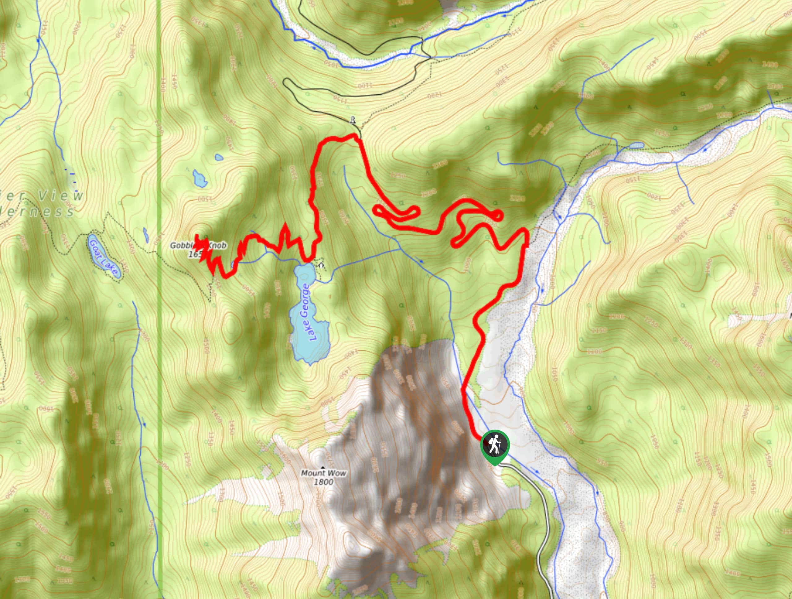
The Gobblers Knob Fire Lookout hike in Mount Rainier National Park is an 11.5mi hard hike that offers wonderful views over the surrounding mountains. This one is a leg burner—steep on the way up, and unrelenting downhill as you descend. It’s worth the effort, though! Bring lots of water and enjoy.
Getting there
The trailhead for the Gobblers knob Fire Lookout is at the end of Westside Road. Take the left turn onto Westside Road from the Nisqually-Entrance-to-Longmire Road, and follow it to the end.

About
| Backcountry Campground | Lake George Camp |
| When to do | June-October |
| Pets allowed | No |
| Family friendly | No |
| Route Signage | Average |
| Crowd Levels | Moderate |
| Route Type | Out and back |
Gobblers Knob Fire Lookout
Elevation Graph
Weather
Gobblers Knob Fire Lookout Hike Description
If you want to get your legs working and enjoy a slice of mountain paradise on the way, try the gobblers Knob Fire Lookout hike. This trail is steep, but it’s a less-busy choice with great views. Some people bring bikes to finish the first section of the hike (which follows the road) more quickly.
From the end of the maintained section of Westside Road, hike northwest along the road, crossing Fish Creek. Stay left at the Y-junction and follow the trail as it winds in big switchbacks.
The trail eventually intersects with Lake George Trail. Stay left here onto Lake George, winding over to the patrol cabin at Lake George. Take a breather here before the final big push to Gobblers Knob.
To descend, retrace your steps, taking care to stay left at the first junction on the descent.
Similar hikes to the Gobblers Knob Fire Lookout hike

Paul Peak Trail
The Paul Peak Trail is a 6.3mi lightly trafficked out and back trail in Mount Rainier National Park…

Narada Falls to Mazama Ridge Loop
The Narada Falls to Mazama Ridge loop is an 7.4mi moderately trafficked route in Mount Rainier National Park…

Camp Summerland via Wonderland Trail
The hike to Camp Summerland on the Wonderland Trail is a 8.4mi moderately trafficked out and back trail…
Comments