
Deer Creek Falls to Owyhigh Lakes Trail
View Photos
Deer Creek Falls to Owyhigh Lakes Trail
Difficulty Rating:
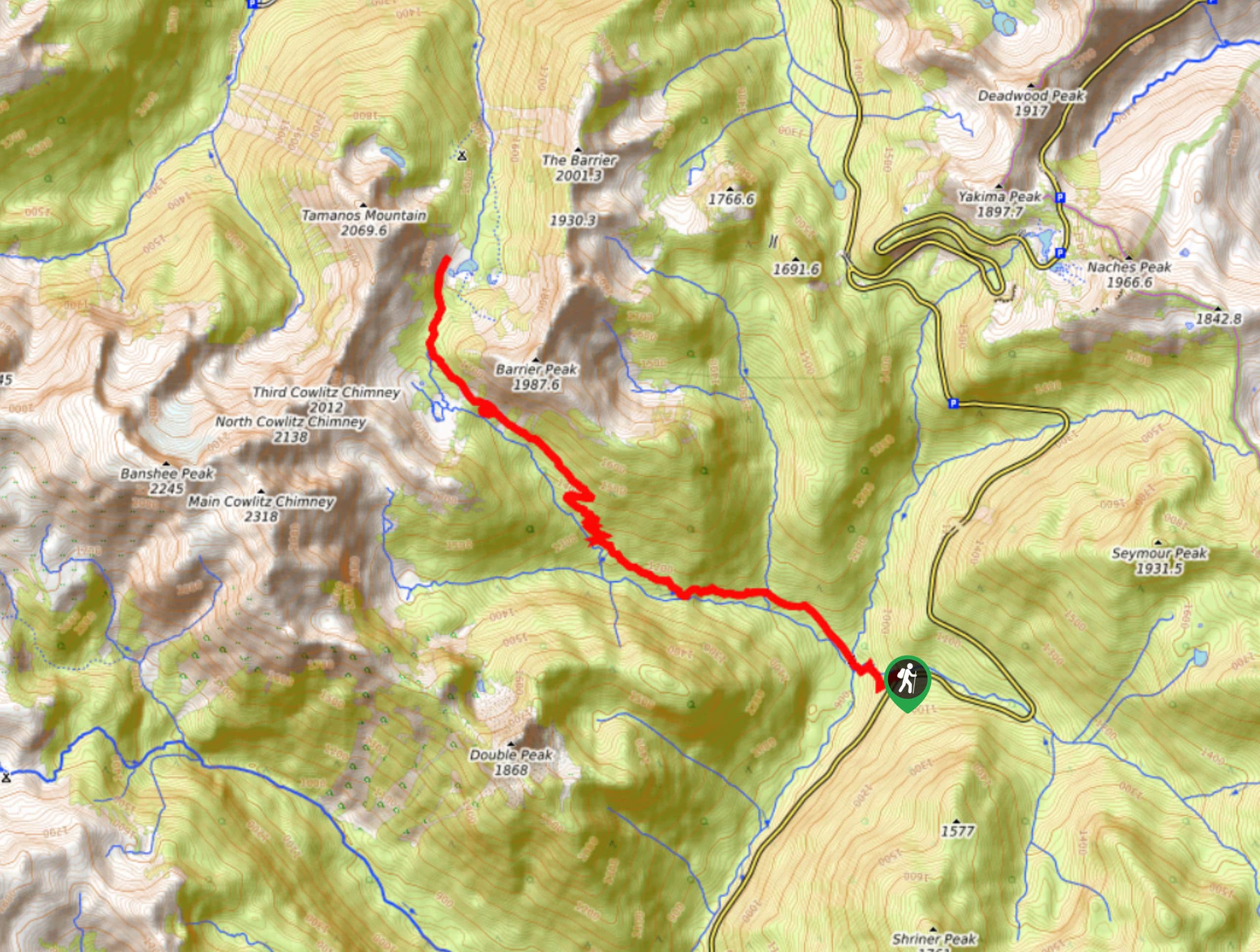
The Deer Creek Falls to Owyhigh Lakes Trail hike is a 9.3mi out and back trail in Mount Rainier National Park that is moderately trafficked and provides the opportunity for extension. While this trail is a pleasant trip in itself, many hikers take it to the trail that leads up Tamanos Mountain or to Tamanos Creek Camp. Note that you need a wilderness pass for this trail and you can’t camp at Owyhigh— just book in at Tamanos instead.
Getting there
The trailhead for the Deer Creek Falls to Owyhigh Lakes Trail is off WA 123 at Deer Creek Camp. From the junction with Stevens Canyon Road, take WA 123 north. The trailhead is on the left before the sharp right turn.

About
| Backcountry Campground | Deer Creek Camp |
| When to do | June-October |
| Pets allowed | No |
| Family friendly | No |
| Route Signage | Average |
| Crowd Levels | Moderate |
| Route Type | Out and back |
Deer Creek Falls to Owyhigh Lakes Trail
Elevation Graph
Weather
Deer Creek Falls to Owyhigh Lakes Trail Description
The hike from Deer Creek Falls to Owyhigh Lakes Trail is a lovely trip on its own, passing through mature forest to the calm Owyhigh Lakes. This trail is also a great choice for those looking to summit Mt. Tamanos or camp at Tamanos Creek Camp.
Begin on the west side of WA 123, passing through Deer Creek Camp and following Needle Creek. The elevation gain is consistent but somewhat gradual until you hit the switchbacks, where you might feel a bit more winded. The views improve here as the trees thin out.
Upon reaching the plateau at the lakes, you can either decide to continue up Mt. Tamanos or turn around and retrace your steps. If you’re camping at Tamanos Creek, continue on Owyhigh Lakes Trail a bit further.
Similar hikes to the Deer Creek Falls to Owyhigh Lakes Trail hike

Paul Peak Trail
The Paul Peak Trail is a 6.3mi lightly trafficked out and back trail in Mount Rainier National Park…

Narada Falls to Mazama Ridge Loop
The Narada Falls to Mazama Ridge loop is an 7.4mi moderately trafficked route in Mount Rainier National Park…

Camp Summerland via Wonderland Trail
The hike to Camp Summerland on the Wonderland Trail is a 8.4mi moderately trafficked out and back trail…
Comments