
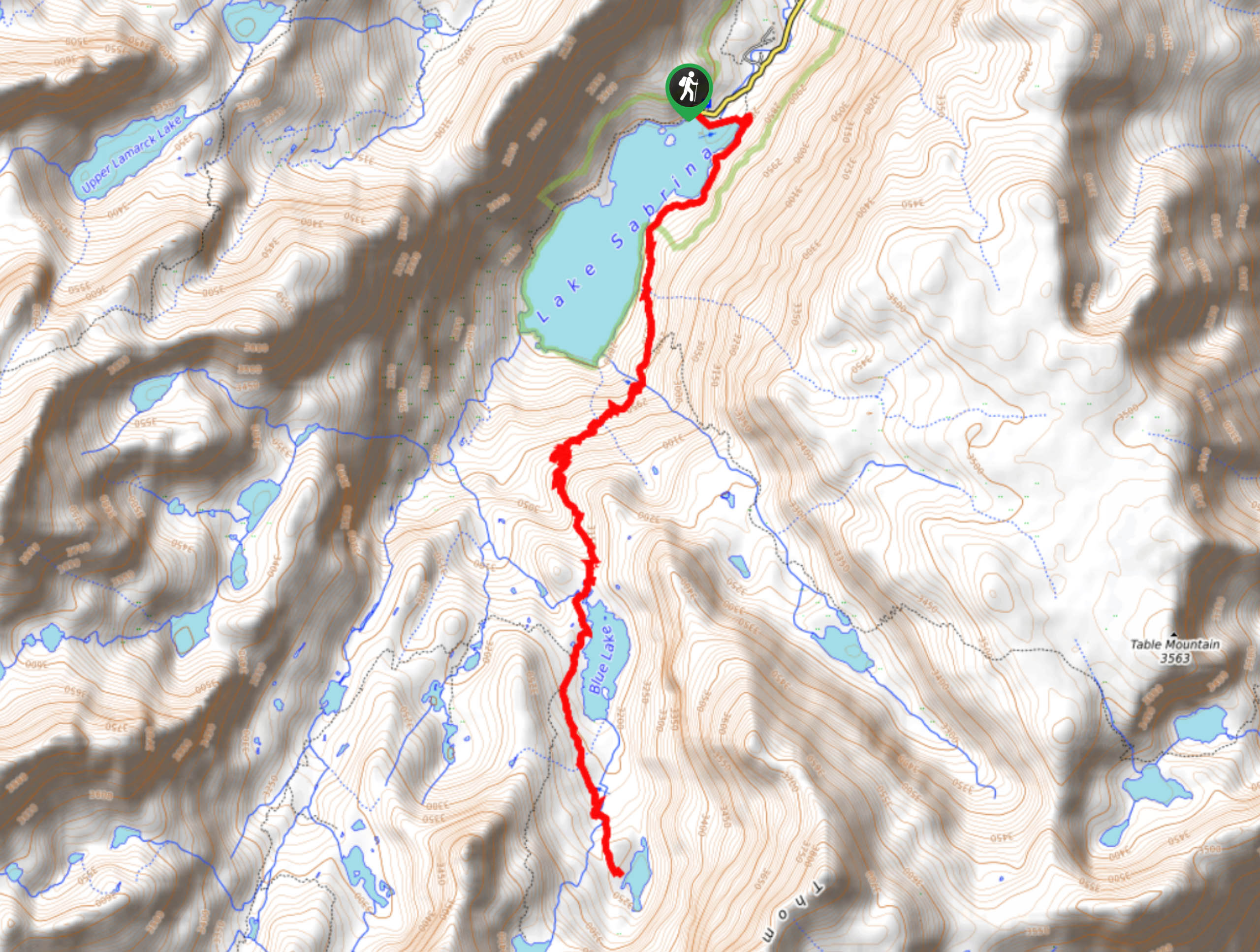
Sabrina Basin to Donkey Lake Trail
View Photos
Sabrina Basin to Donkey Lake Trail
Difficulty Rating:
Sabrina Basin to Donkey Lake Trail is a scenic route within Inyo National Forest that is well suited for intermediate hikers and families with older children. Boasting incredible views of the surrounding eastern Sierra Nevada Mountain range, the route can be done in a day or broken up into a backpacking trip.
Getting there
The trailhead for Sabrina Basin to Donkey Lake Trail is located at a parking lot off of Lake Sabrina Road.

About
| Backcountry Campground | |
| When to do | July-September |
| Pets allowed | Yes |
| Family friendly | Older Children only |
| Route Signage | Average |
| Crowd Levels | Moderate |
| Route Type | Out and back |
Sabrina Basin to Donkey Lake Trail
Elevation Graph
Weather
Sabrina Basin to Donkey Lake Trail Description
Sabrina Basin to Donkey Lake Trail’s distance and elevation incline make it a moderately difficult route. As such, it is likely not appropriate for beginner hikers and families with young children. Sabrina Basin to Donkey Lake Trail is rather steep in some sections, so it is recommended that you wear good hiking shoes.
Having made it to the trailhead, follow the Sabrina Basin Trail as it makes its way alongside the shoreline of Lake Sabrina. After crossing a creek, the route will veer away from the eastern shore of the lake and arrive at a junction within the trail. At the junction, take the southern pathway as it leads you up a series of switchbacks. The Sabrina Basin to Donkey Lake Trail will then straighten out while continuing to incline in elevation.
The route will soon deliver you to Blue lake. Passing adjacent to the western shore of the lake, the route will arrive at a second junction. Take the eastern pathway and follow it as it takes you over two creeks and brings you to Donkey Lake. Enjoy the nice sightlines and perhaps stop for some lunch! When you’re ready, simply backtrack your steps towards the trailhead and your waiting vehicle.
Similar hikes to the Sabrina Basin to Donkey Lake Trail hike

Valentine Lake Trail
An underrated route within Inyo National Forest, Valentine Lake Trail is without a doubt worth the effort! Boasting sublime scenery…

Lakes Basin Path to Pack Trail
A more challenging route within Inyo National Forest, Lakes Basin Path to Pack Trail is ideal for more experienced hikers…

Mountain View and 3S89 Road Loop
Mountain View and 3S89 Road Loop is a delightful route within Inyo National Forest. Leading you through a lovely forested…
Comments