
Reversed Peak Trail
View Photos
Reversed Peak Trail
Difficulty Rating:
Reversed Peak Trail is undoubtedly an underrated route within Inyo National Forest. A lightly trafficked pathway, Reversed Peak Trail boasts mesmerizing sightlines of the surrounding Inyo National Forest landscape and is considered to be an excellent route for wildlife viewing.
Getting there
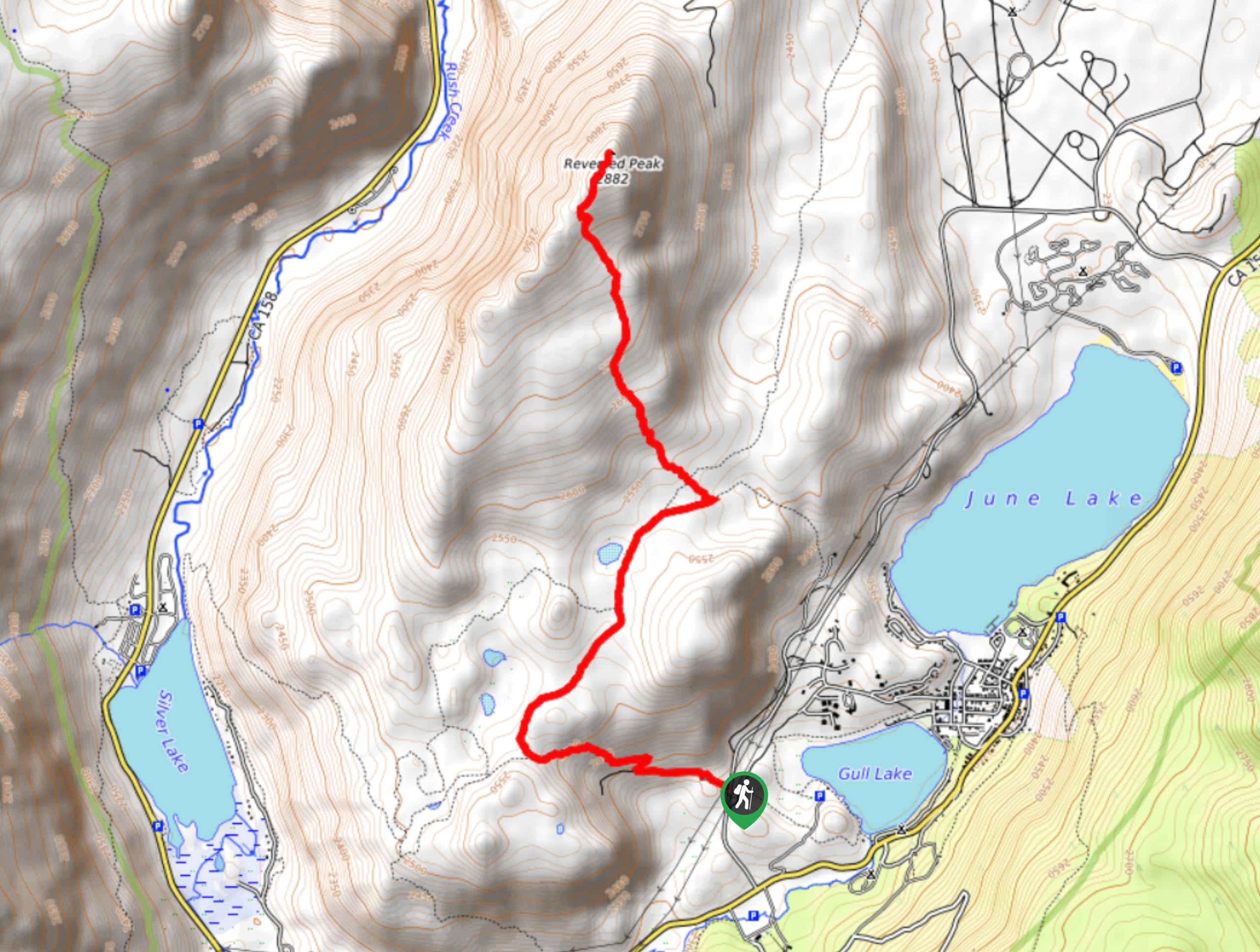
The trailhead for Reversed Peak Trail is located off of Northshore Drive.

About
| Backcountry Campground | |
| When to do | May-September |
| Pets allowed | No |
| Family friendly | Older Children only |
| Route Signage | Average |
| Crowd Levels | Low |
| Route Type | Out and back |
Reversed Peak Trail
Elevation Graph
Weather
Reversed Peak Trail Description
While Reversed Peak Trail is considered appropriate for families with older children, keep in mind that the summit of Reversed Peak requires a small amount of scrambling. Those not comfortable with this more-involved method of inclining elevation may want to skip the summit in favore of the still incredible views found below. Likewise, Reversed Peak Trail is in the high alpine environment of the eastern Sierra Nevada Mountain range, so it is important that you monitor yourself and your group members for signs of altitude sickness.
Having arrived at the trailhead, follow the Reversed Peak Loop Trail as it makes its way west over steadily inclining terrain. Throughout the duration of the route, you will arrive at several junctions within the trail. As long as you stay on the Reversed Peak Loop Trail through each junction, you will arrive at Reversed Peak with no issues.
After completing the initial steep section, the route plateaus as it heads to the north. Continuing on its northern heading, the Reversed Peak Loop Trail will bring you alongside the eastern shore of Snow Pond before inclining in elevation steadily once again. From here, the elevation continues to incline until you reach the summit of Reversed Peak. Once you have summited, take in the incredible views and have a rest – you’ve earned it! Once you’re ready, simply backtrack your steps towards the trailhead.
Similar hikes to the Reversed Peak Trail hike

Valentine Lake Trail
An underrated route within Inyo National Forest, Valentine Lake Trail is without a doubt worth the effort! Boasting sublime scenery…

Lakes Basin Path to Pack Trail
A more challenging route within Inyo National Forest, Lakes Basin Path to Pack Trail is ideal for more experienced hikers…

Mountain View and 3S89 Road Loop
Mountain View and 3S89 Road Loop is a delightful route within Inyo National Forest. Leading you through a lovely forested…
Comments