
Lone Pine Campground to Whitney Portal Trail
View Photos
Lone Pine Campground to Whitney Portal Trail
Difficulty Rating:
The Lone Pine Campground to Whitney Portal Trail boasts incredible views of the surrounding landscape. Sightlines of the imposing mountains of the eastern Sierra Nevada range can be enjoyed throughout the route's duration as the pathway takes you alongside charming Lone Pine Creek.
Getting there
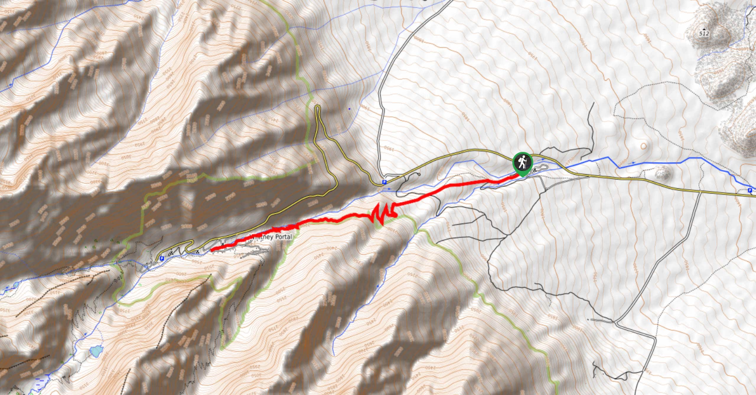
The trailhead for Lone Pine Campground to WHitney Portal Trail is located at Lone Pine Campground.

About
| Backcountry Campground | |
| When to do | June-October |
| Pets allowed | No |
| Family friendly | Older Children only |
| Route Signage | Average |
| Crowd Levels | Moderate |
| Route Type | Out and back |
Lone Pine Campground to Whitney Portal Trail
Elevation Graph
Weather
Lone Pine Campground to Whitney Portal Trail Description
As the Lone Pine Campground to Whitney Portal Trail is within the high alpine environment of the eastern Sierra Nevada Mountain range, it is important that you monitor yourself and your group members for the effects of altitude sickness. Ensure you are drinking lots of water and eating throughout the route, as the high altitude will likely make the route more physically challenging than it otherwise would be.
Having left your vehicle at Lone Pine Campground, follow the Whitney Portal Trail as it makes its way west. You will soon arrive at a junction within the trail; stay on Whitney Portal Trail by taking the westernmost pathway. After the first junction, the incline will begin to increase steadily before the pathway delivers you to another junction within the trail.
At the second junction, continue on along Whitney Portal Trail by once again following the westernmost pathway towards the steep terrain in the foreground. The Lone Pine Campground to Whitney Portal Trail will then begin to incline in elevation more rapidly and the pathway will turn into a series of switchbacks. Having completed the switchback section, the route will traverse a hillside adjacent to Lone Pine Creek. You will soon arrive at Whitney Portal Family Campground, where you should take some time to rest and enjoy the views before backtracking your steps towards the trailhead.
Similar hikes to the Lone Pine Campground to Whitney Portal Trail hike

Valentine Lake Trail
An underrated route within Inyo National Forest, Valentine Lake Trail is without a doubt worth the effort! Boasting sublime scenery…

Lakes Basin Path to Pack Trail
A more challenging route within Inyo National Forest, Lakes Basin Path to Pack Trail is ideal for more experienced hikers…

Mountain View and 3S89 Road Loop
Mountain View and 3S89 Road Loop is a delightful route within Inyo National Forest. Leading you through a lovely forested…
Comments