
Gibbs Lake Trail
View Photos
Gibbs Lake Trail
Difficulty Rating:
The Gibbs Lake Trail is a stunning route within Inyo National Forest that leads you through impressive mountain terrain before ending at the charming Gibbs Lake. An excellent place to view wildlife, GIbbs Lake Trail is rated as moderately difficult and is therefore perfect for intermediate hikers and families with older children.
Getting there
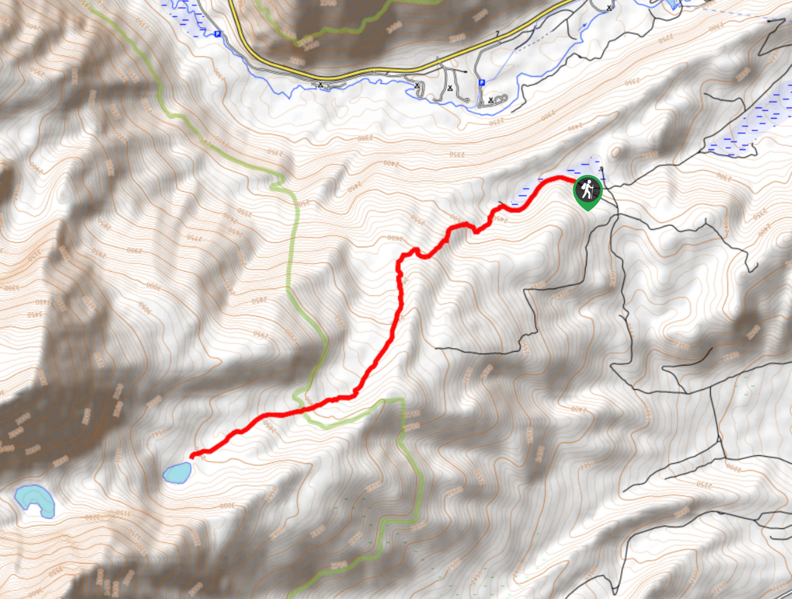
The trailhead for Gibbs Lake Trail is located off of Horse Meadows Road.

About
| Backcountry Campground | |
| When to do | July-October |
| Pets allowed | Yes |
| Family friendly | Older Children only |
| Route Signage | Poor |
| Crowd Levels | Moderate |
| Route Type | Out and back |
Gibbs Lake Trail
Elevation Graph
Weather
Gibbs Lake Trail Description
The trailhead for Gibbs Lake Trail is located along an unpaved road, so we recommend having a vehicle with four-wheel drive and high clearance if you are planning on doing the route. Gibbs Lake Trail also possesses a fair amount of elevation incline in relation to its distance, so it is likely not appropriate for beginner hikers and families with young children.
With your vehicle parked along Horse Meadows Road, follow 1N106 Bohler Canyon as it makes its way west adjacent to Upper Horse Meadow. The pathway will begin to veer to the southwest as it begins to incline in elevation rather steeply. After reaching a short plateau, the elevation will again begin to inline – albeit this time more gradually.
Continuing on southwest, the trail will deliver you to Gibbs Lake, where you should take some time and enjoy the incredible sightlines. Once you have had an opportunity to take in the scenery, and perhaps stop for a picnic, backtrack your steps towards the trailhead, and your waiting vehicle.
Similar hikes to the Gibbs Lake Trail hike

Valentine Lake Trail
An underrated route within Inyo National Forest, Valentine Lake Trail is without a doubt worth the effort! Boasting sublime scenery…

Lakes Basin Path to Pack Trail
A more challenging route within Inyo National Forest, Lakes Basin Path to Pack Trail is ideal for more experienced hikers…

Mountain View and 3S89 Road Loop
Mountain View and 3S89 Road Loop is a delightful route within Inyo National Forest. Leading you through a lovely forested…
Comments