Scalplock Lookout Trail
View Photos
Scalplock Lookout Trail
Difficulty Rating:
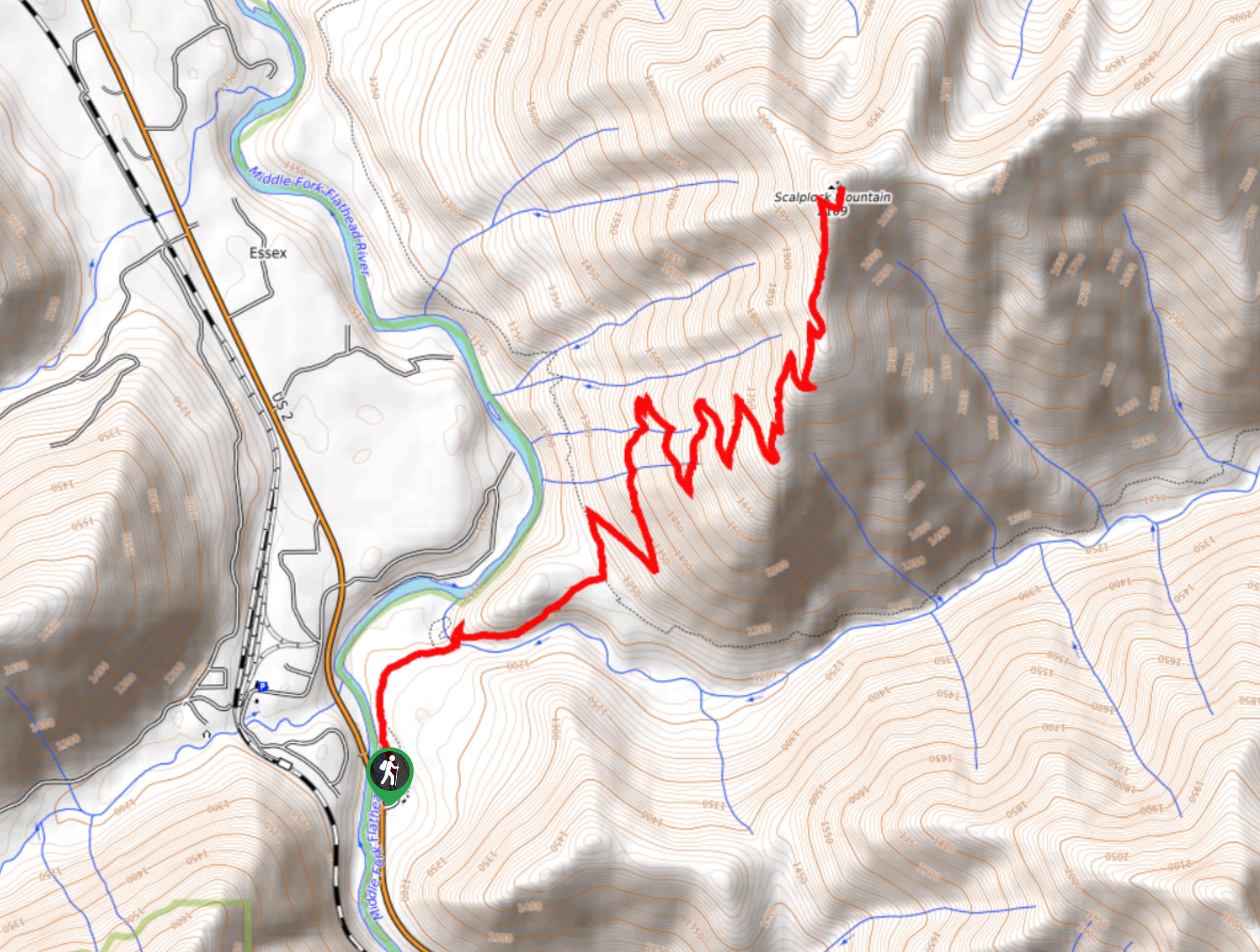
Scalplock Lookout Trail is a challenging hike that continues with a steady grade all the way to the top. Once you reach the lookout, you are rewarded with stunning views of the Southern area of Glacier National Park. This hike takes you through the wilderness and has you going through mostly forest to get to the captivating sights ahead.
Getting there
To get to Scalplock Lookout Trail from Essex, head northeast on Izaak Walton Road/Izaak Walton Inn Road toward US-2 West. After 0.6mi, continue onto Hawkes Lane/Patti's Road and after 0.7mi, you will arrive at your destination.

About
| When to do | March - October |
| Backcountry Campsites | No |
| Pets allowed | No |
| Family friendly | No |
| Route Signage | Average |
| Crowd Levels | Low |
| Route Type | Out and back |
Scalplock Lookout Trail
Elevation Graph
Weather
Scalplock Lookout Trail Description
Explore Scalplock Lookout Trail in Glacier National Park and hike through beautiful forestry with a steady grade to reach captivating views of the Southern area of the park. The trail begins at Walter Ranger Station and continues on the South Boundary Trail. After hiking through the forested area, the trees will begin to open up and the rugged mountain peaks will come into view.
Following the trail, you will arrive at the lookout and be met with stunning views of Scalplock Mountain and many others far in the distance. This is an out-and-back trail, so when you are done taking in the scenery, return the way you came.
Find more epic hikes in Glacier National Park
Similar hikes to the Scalplock Lookout Trail hike

Fish Lake Trail
Fish Lake Trail is a mix between relaxing and heart pumping. The start of the trail takes you through a…

Quartz Creek Trail
Quartz Creek Trail is a relaxing hike on a remote trail in Glacier National Park. The hike takes you through…

Snyder Ridge Trail
Hiking through Snyder Ridge Trail takes you through a forest for most of the trail that follows the ridge along…
Comments