
Three Corner Rock Hike
View Photos
Three Corner Rock Hike
Difficulty Rating:
Three Corner Rock is a unique formation atop a hill that overlooks all the big ones: Mount Adams, Mount Rainier, and Mount Saint Helens. It’s a moderate hike at 3.8mi but the views are what you’d expect of a much more demanding trek. This hike sees moderate traffic and is best done on a clear day when the views are the best.
This trail is well-graded and generally well-kept. Some logging has occurred around the trail in recent years but this doesn’t detract too much from the overall experience.
There is another route to Three Corner Rock that clocks in at 9.0mi roundtrip with 1900ft of elevation gain. This route follows the PCT. The route described in this guide is shorter, more direct, and easier.
This trail is closed indefinitely. We will update this page when it reopens.
Getting there
The trailhead for the Three Corner Rock hike is on DNR Road CG 2000.

About
| Backcountry Campground | No |
| When to do | May-November |
| Pets allowed | Yes |
| Family friendly | Older Children only |
| Route Signage | Average |
| Crowd Levels | Moderate |
| Route Type | Out and back |
Three Corner Rock Hike
Elevation Graph
Weather
Three Corner Rock Hike Description
Three Corner Rock itself is neat, popping out of the top of a grassy hill seemingly out of nowhere. However, the real star of the show on this hike is the expansive view from where the rock stands. On a clear day, you’ll look all the way to Mount Adams, Mount Jefferson, Mount Rainier, and Mount Saint Helens. It’s a fantastic view!
As if the mountains weren’t enough, the forest on the way up is also gorgeous. There are multiple old firs and hemlock trees and there are wildflowers along the trail in the early summertime.
This trail is susceptible to a bit of overgrowth, but it’s normally not too severe. The last section to the top of the ridge requires a bit of hands-on moving, so small children may struggle.
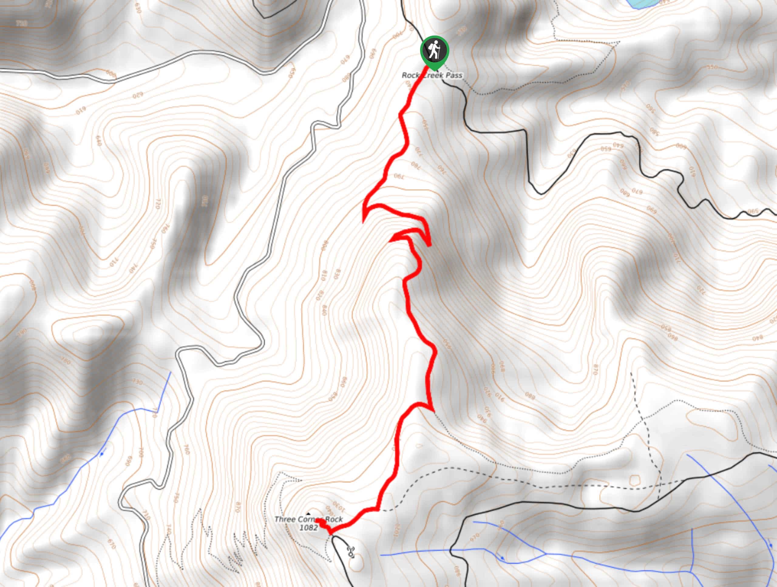
Begin from the trailhead, which is where the PCT crosses Road CG 2090. Hike through the trees for about a mile and a half until you reach a sign that indicates the junction with Three Corner Rock Trail. Go right here. You’ll hike through the woods to where the trail ends at an offroading road.
At the trail end, turn right and deal with a few steps on an eroded trail to a 4-way junction. Going straight takes you onto the Three Corner Rock Trail, but the rock itself is to the right.
Take the spur road to Three Corner Rock. You’ll use concrete steps to get up near the rock, and then you’ll need to scramble a bit to reach it. The views are breathtaking, so spend some time snapping photos and admiring them.
Look for Mount Hood to the south, Mount Rainier and Mount Saint Helens to the north, and Mount Adams to the northeast. You can also see some of the Columbia River and the Columbia River Gorge.
When you’re ready, head back to the trailhead the same way you came up.
Hiking Route Highlights
Mount Saint Helens
Mount Saint Helens is an active volcano, last erupting in May of 1980, taking 57 lives and destroying 200 homes. The volcano is 8363ft high. Previously the summit was at 9677ft, but it was shortened in a lateral eruption triggered by an earthquake. Mount Saint Helens was originally named Lawetlat’la by the Cowlitz people.
Mount Rainier
The tallest mountain in the state is a dominant part of your view on the High Rock Lookout. This 14409ft stratovolcano is an iconic sight and is clearly visible from your perch on this trail. Mount Rainier is the tallest mountain in Washington State. Mount Rainier was originally called Tahoma by the Indigenous peoples in the region.
Frequently Asked Questions
Is Three Corner Rock kid-friendly?
Kids may struggle with the final scramble to the rock. Older children should be more comfortable completing this section.
Is Three Corner Rock open?
Check the Washington Department of Natural Resources site for updates on the status of this hike.
Insider Hints
Try to plan this hike for a clear day.
Some sections of the trail may become slippery in the trail, so a clear day is recommended.
Similar hikes to the Three Corner Rock Hike hike

Ptarmigan Trail
Ptarmigan Trail is a 4.2mi moderate trail near the base of Mount Saint Helens. This trail is suitable…

Boundary West Trail
Boundary West Trail is a hike near Mount Saint Helens that doesn’t see much traffic, making it a nice pick…

Silver Creek Trail
Silver Creek Trail is a moderate hike in the Gifford Pinchot National Forest that is suitable for most skill levels.…
Comments