Placid Lake Trail
View Photos
Placid Lake Trail
Difficulty Rating:
Placid Lake Trail is a short, easy trail that leads you to the shores of a calm lake. This is a nice spot for a hot day, especially since it’s never that busy. Bring an inflatable kayak or a paddleboard, pitch your tent, and enjoy the solitude of Indian Heaven Wilderness. This hike is 17.0mi long and rated as easy. You’ll want a potent bug spray if you’re here before mid-August.
Getting there
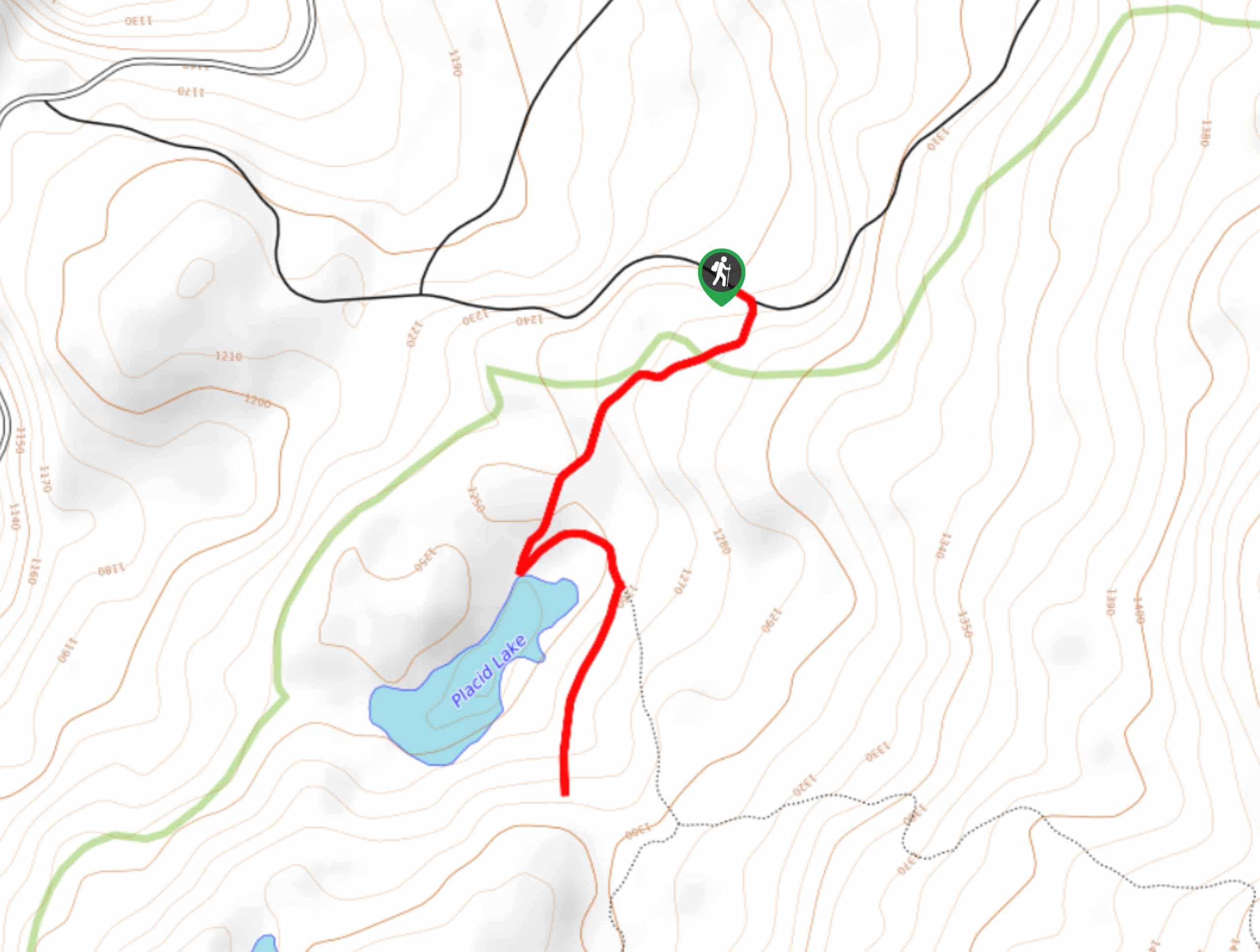
The trailhead for the Placid Lake Trail is on Forest Road 420.

About
| Backcountry Campground | Placid Lake Backcountry |
| When to do | July-October |
| Pets allowed | Yes - On Leash |
| Family friendly | Yes |
| Route Signage | Average |
| Crowd Levels | Moderate |
| Route Type | Out and back |
Placid Lake Trail
Elevation Graph
Weather
Placid Lake Trail Description
Placid Lake, true to its name, is a calm little lake tucked away in Indian Heaven Wilderness. It’s great for a lazy paddle or for a simple backpacking trip. The trail to the lake is very short and easy. You’ll want to bring all the mosquito protection you can get if you’re here before about mid-August when the bugs tend to ease up.
Begin from the parking area on the forest road. It’s a very short and easy trip to the lake, which makes backpacking or bringing in a paddleboard or kayak nice as making extra trips to the car isn’t a dramatic affair. The short trail takes you right to the lakeshore. There isn’t a trail that loops the lake, so you’ll need to bushwhack a bit if you want to.
When you’re ready to return, retrace your steps on the same route.
Similar hikes to the Placid Lake Trail hike

Ptarmigan Trail
Ptarmigan Trail is a 4.2mi moderate trail near the base of Mount Saint Helens. This trail is suitable…

Boundary West Trail
Boundary West Trail is a hike near Mount Saint Helens that doesn’t see much traffic, making it a nice pick…

Silver Creek Trail
Silver Creek Trail is a moderate hike in the Gifford Pinchot National Forest that is suitable for most skill levels.…
Comments