
Hidden Falls via Tarbell Trail
View Photos
Hidden Falls via Tarbell Trail
Difficulty Rating:
Hidden Falls via Tarbell Trail is a moderate 10.9mi hike in Yacolt Burn State Park. This hike features waterfalls, but longer adventures on the Tarbell Trail can take you very far and through changing scenery. In this section, you’ll stroll through a very lush forest, check out multiple waterfalls, and explore clear-cut areas that open up your view. There are a few steep sections where poles would be helpful. These sections may be too steep for younger children.
The trail lacks shade in the clear-cut areas and can get quite hot, so prepare accordingly if you’re hiking on a sunny day. Long pants are also recommended for short sections with poison ivy in the bushes- staying on the trail is a must!
Getting there
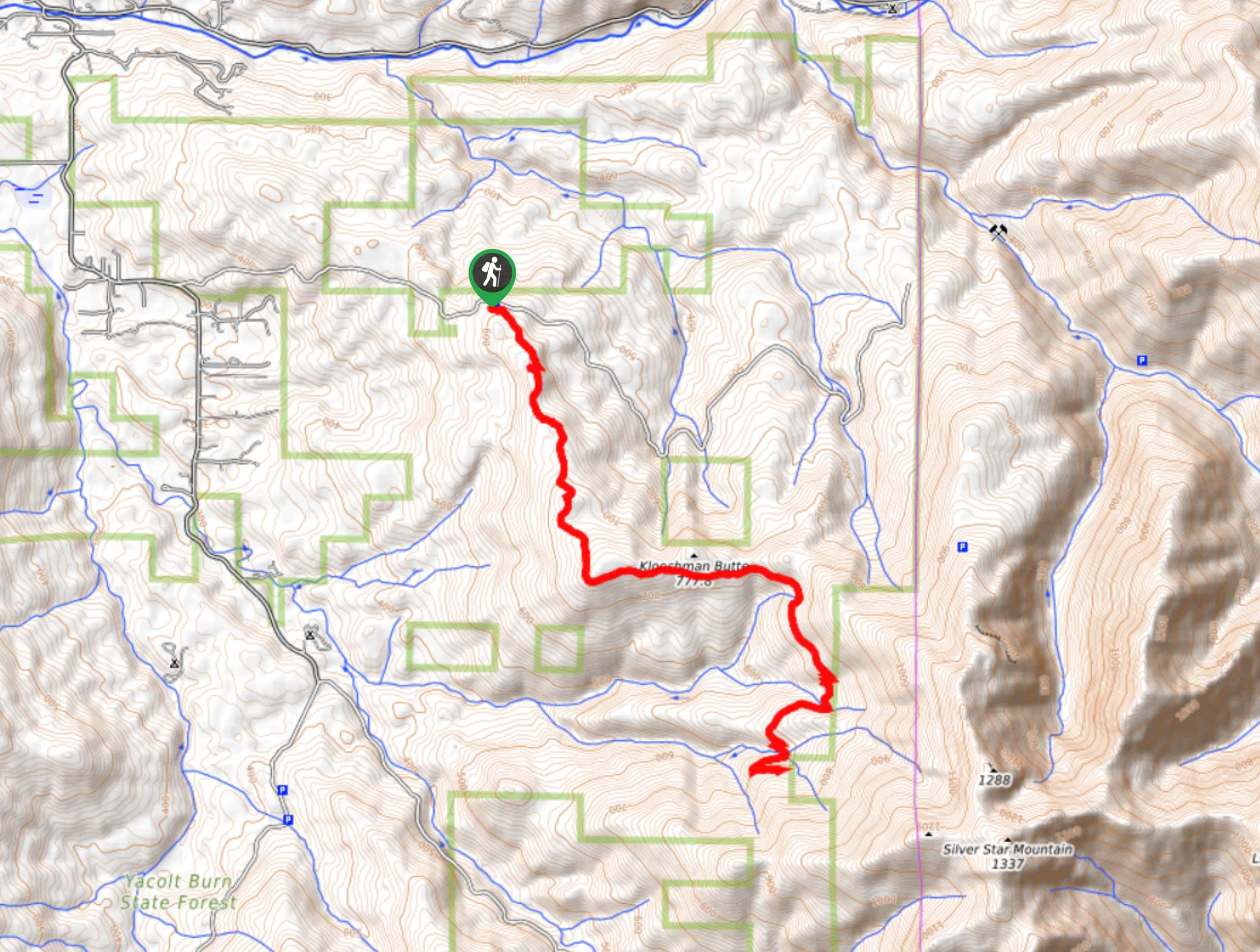
The trailhead for the Hidden Falls hike on Tarbell Trail is off L-1100 Road.

About
| Backcountry Campground | No |
| When to do | Year-round |
| Pets allowed | Yes - On Leash |
| Family friendly | Older Children only |
| Route Signage | Average |
| Crowd Levels | High |
| Route Type | Out and back |
Hidden Falls via Tarbell Trail
Elevation Graph
Weather
Hidden Falls via Tarbell Trail Description
Waterfalls, mushrooms, thick foliage, views out over the forest- the hike to Hidden Falls on Tarbell Trail has so much to offer. This trip makes use of a portion of the longer Tarbell Trail, so make sure you start at the Yacolt area trailhead, as there are several for Tarbell Trail.
There are lots of intersecting trails on this route. We recommend downloading your GPS track ahead of time to ensure you’re staying on the right route.
While this trail is very enjoyable, there are a few things to consider before you head out. It’s unshaded in the clear-cut areas, so come prepared if you’re hiking on a hot day. Additionally, some parts of the trail are a touch overgrown, and users report seeing poison ivy in the underbrush. Wear long pants and stay on the trail to avoid any itchy encounters. Finally, poles are recommended for the steep portions of the trail.
Horses and mountain bikers may also use this trail, so remember to share it if needed.
Beginning from the trailhead, you’ll take Tarbell Trail (on your left). Go straight where it intersects with the old road and then continue straight where small spur trails intersect. The route curves to your left atop a small hill to traverse to Kloochman Butte.
Continue past the butte and go straight through a junction. After a few switchbacks to drop elevation, you’ll cross a stream. At the junction with Appaloosa Trail, stay left and look for the falls ahead. Passing into the national forest, this section of the trail terminates at the next Y-junction.
From the junction, turn back and admire the falls once more before retracing your steps back to the trailhead. If you don’t want to hike past the falls, they make a perfect turnaround point.
Hiking Route Highlights
Hidden Falls
The roughly 90ft Hidden Falls is the perfect midpoint on this hike. They cascade into Coyote Creek, creating a cool, misty area that can be explored and enjoyed by hikers of all ages. The falls are great most times of the year, but we especially enjoy them after a spring rain.
Frequently Asked Questions
Is Hidden Falls Trail hard?
The trail is moderately difficult with a few steep ascents and descents, but strong beginners and better should be able to complete it.
Is Hidden Falls in a park?
Hidden Falls is just within Gifford-Pinchot National Forest.
Is Hidden Falls kid-friendly?
The hike to the falls might be too long and hard for small children, but older children should be more capable of reaching them. As always, take caution when bringing children near waterfalls. We don’t recommend trying to swim in the fall pool due to the risk inherent in swimming under the falls and the speed of Coyote Creek.
Insider Hints
Watch for horse droppings on the trail; there tend to be lots.
Wear tick spray and preferably long clothing on this hike. Users report being bitten by ticks and having their dogs bitten by ticks.
Similar hikes to the Hidden Falls via Tarbell Trail hike

Ptarmigan Trail
Ptarmigan Trail is a 4.2mi moderate trail near the base of Mount Saint Helens. This trail is suitable…

Boundary West Trail
Boundary West Trail is a hike near Mount Saint Helens that doesn’t see much traffic, making it a nice pick…

Silver Creek Trail
Silver Creek Trail is a moderate hike in the Gifford Pinchot National Forest that is suitable for most skill levels.…
Comments