Dog Mountain Trail
View Photos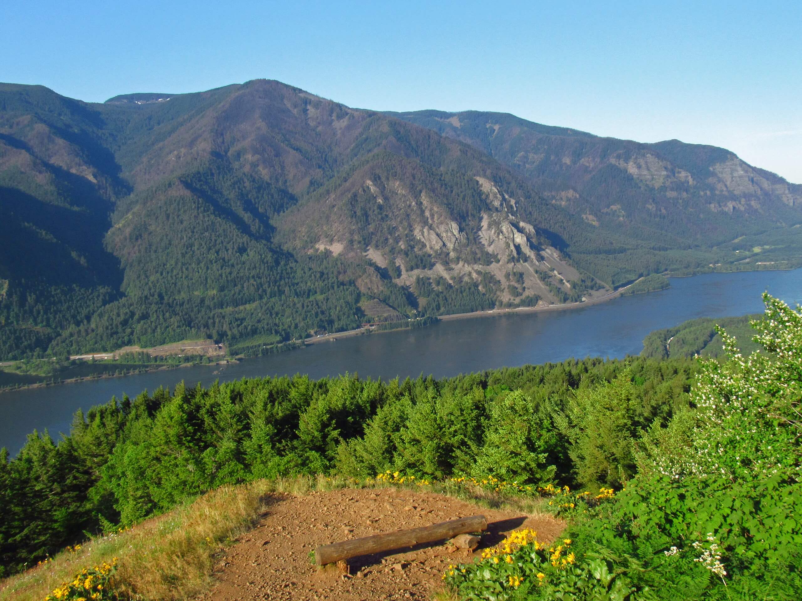
Dog Mountain Trail
Difficulty Rating:
Dog Mountain Trail is one of the most sought-after hikes in the Columbia River Gorge. This 6.5mi loop trek is considered hard, with a straight-up stair stepper climb required. More experienced hikers often find it to be very manageable, but beginners may find it quite demanding. However, the changing scenery and foliage make for a highly enjoyable trip well worth the crowds. Expect heavy traffic and come prepared for a very windy summit.
The hike begins with temperate and high-desert flora, but it gives way to a cool rainforest and then vibrant flower-filled meadows with mountain views. Make sure you have your passes in order (see Insider Tips) and arrive early to secure a spot in the parking lot.
Getting there
The trailhead for the Dog Mountain Trail is off Lewis and Clark Trail Highway.

About
| Backcountry Campground | No |
| When to do | April-November |
| Pets allowed | Yes - On Leash |
| Family friendly | No |
| Route Signage | Average |
| Crowd Levels | High |
| Route Type | Loop |
Dog Mountain Trail
Elevation Graph
Weather
Dog Mountain Trail Description
Dog Mountain is a very popular hike because of its splendid wildflowers, great views over the Columbia River, and sightlines across to nearby mountains, including a stellar view of Mount Hood on clear days. It sees plenty of visitors each year, but it’s worth dealing with the heavier traffic.
This hike will likely feel quite challenging to beginner hikers and may be too difficult for young kids. If you do bring young kids, be careful on the narrow, exposed top portion of the trail when the wind gusts, which it often does. A windbreaker is definitely recommended.
The parking area is on the small side and will fill up on the weekends. We recommend arriving early. This hike requires a parking permit in addition to your hiking pass, but reserving your permit does not guarantee you a parking spot.
You’ll start with a 0.5mi ascent through the woods to a junction. Keep right here. This guide reflects the trail as a loop using the Augspurger Mountain Trail, and doing it as a loop instead of out and back helps keep the congestion down as much as possible. It’s also a bit easier.
A mile further, you’ll arrive at a viewpoint over the Columbia River and Wind Mountain. If you’re not wanting to complete the full hike, this is a good turnaround spot.
Another half of a mile brings you to a junction. Stay right and continue to the site of the former fire lookout. The views here are worth a pause.
Continuing on, you’ll hike a 0.5mi to the meadow, which is simply gorgeous when the wildflowers are in bloom. You’ll skirt the top of a cliff here- this is the part where small kids should be watched closely. It’s exposed and tends to be gusty.
Arriving at the summit, you’ll likely share your views with many other hikers, but it doesn’t make them any less beautiful.
From the summit, it’s back down to the car. A tenth of a mile from the meadow, go right at the junction. After another 1.1mi, go left. This will have you back to the parking lot in 2.7 miles. If you want a harder descent, follow the Dog Mountain Trail instead by retracing your steps.
Hiking Route Highlights
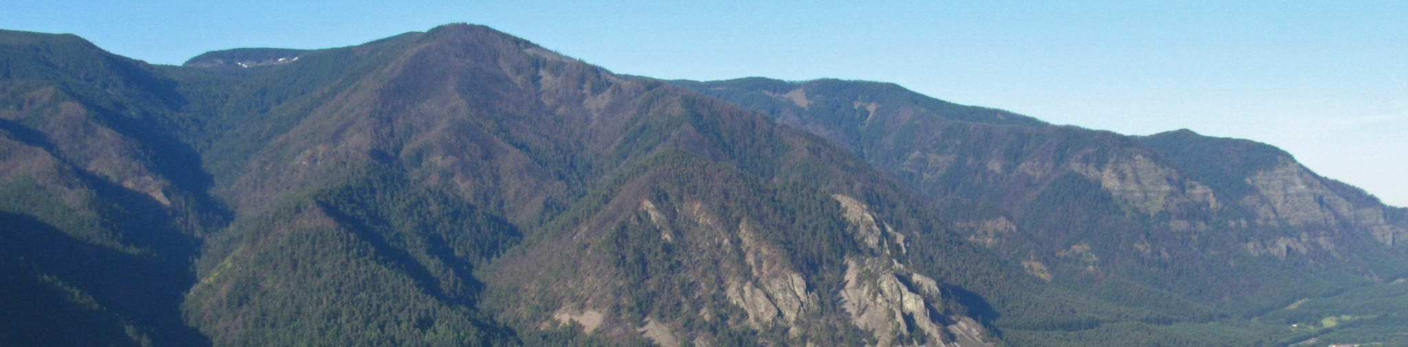
Columbia River Gorge
The view from Dog Mountain features the Columbia River Gorge, where the river slices through the mountains. This portion of the gorge is lined by Dog Mountain, Shellrock Mountain, Augspurger Mountain, Cook Hill, and Wygant Peak. Between the mountains and the blue of the river, it’s a gorgeous spot.
Frequently Asked Questions
Is Dog Mountain safe?
There is a part of the hike that is exposed and subject to high, gusty winds. While this doesn’t present too much of a challenge for most hikers, small children may need assistance and should be carefully watched if you’ve brought them along.
What is the best time to hike Dog Mountain?
In terms of seasons, the best time to hike Dog Mountain is in the late spring through the early summer when the wildflowers are in bloom. When it comes to the time of day, we recommend an early morning or later afternoon hike to miss the crowds as much as possible.
Is Dog Mountain Trail dog friendly?
Yes, dogs are allowed but must be kept on a leash the entire time.
Insider Hints
You’ll need a hiking pass (an America the Beautiful Pass or Northwest Forest Pass) and a permit for this hike. The permits are required for hikers on Saturdays and Sundays between April 24 and June 13 (dates subject to change each year) and cost $1 (prices subject to change). You’ll need to reserve yours in advance.
Permits do not guarantee you’ll get a parking spot. Come early!
Poles, good boots, and a windbreaker will make this hike more enjoyable.
Similar hikes to the Dog Mountain Trail hike

Ptarmigan Trail
Ptarmigan Trail is a 4.2mi moderate trail near the base of Mount Saint Helens. This trail is suitable…

Lakes Trail #211 Loop
The Lakes Trail #211 Loop is used as both a full-day hike and for backpacking trips. This trail isn’t for…

Boundary West Trail
Boundary West Trail is a hike near Mount Saint Helens that doesn’t see much traffic, making it a nice pick…
Comments