Beacon Rock Trail
View PhotosBeacon Rock Trail
Difficulty Rating:
Beacon Rock Trail takes you through Beacon Rock State Park to an awesome viewpoint over the Columbia River Gorge. This 1.5mi out and back route is less of a hike in the classic sense and more of a pleasant walk with a gentle, consistent incline. The route is paved or on a boardwalk, making it a nice choice for those who prefer even footing. It does tend to get busy in the summertime, but visiting later in the day or in the spring and fall should earn you a quieter trail.
There is a fee to access the parking area for this hike, or you can use a Discover Pass.
Getting there
The trailhead for the Beacon Rock Trail is on State Highway 14 near the Beacon Rock Park Headquarters.

About
| Backcountry Campground | No |
| When to do | Year-round |
| Pets allowed | Yes - On Leash |
| Family friendly | Yes |
| Route Signage | Average |
| Crowd Levels | High |
| Route Type | Out and back |
Beacon Rock Trail
Elevation Graph
Weather
Beacon Rock Trail Description
Beacon Rock Trail is a perfect way to enjoy the natural beauty of Beacon Rock State Park. The viewpoint gives you an excellent view over the Columbia River Gorge. The hike gains a fair amount of elevation, but the path is well-constructed and easy to follow. It offers plenty of places to stop for a breather if needed.
The rock itself is an 848ft basalt column that used to sit in the core of a volcano. Over many years, glaciers and water wore away the rest of the volcano and left Beacon rock behind. It was named “Che-Che-op-tin,” which means “the navel of the world.” Fitting given its history! The rock was first climbed in 1901 and the climbing route today follows the original.
The bridge was recently repaired after being damaged. It’s in perfect condition and
From the parking area, you’ll start climbing immediately. While there are over 800ft to climb in a mile, it’s actually quite gentle. Rails and a boardwalk guide you up the south side of the rock, where you’ll switchback as you pop in and out of the trees.
Continue through the turns, steadily gaining elevation. Take a break to see the views through the trees if needed.
At the summit, you’ll encounter a sign that congratulates you on your climb- how nice! You’ll be able to see far upriver towards the Bonneville Dam. Look over the mountains on the other side of the river and into the sparkling blue water far below.
From the top, you’ll follow the same route back down to the bottom.
Hiking Route Highlights
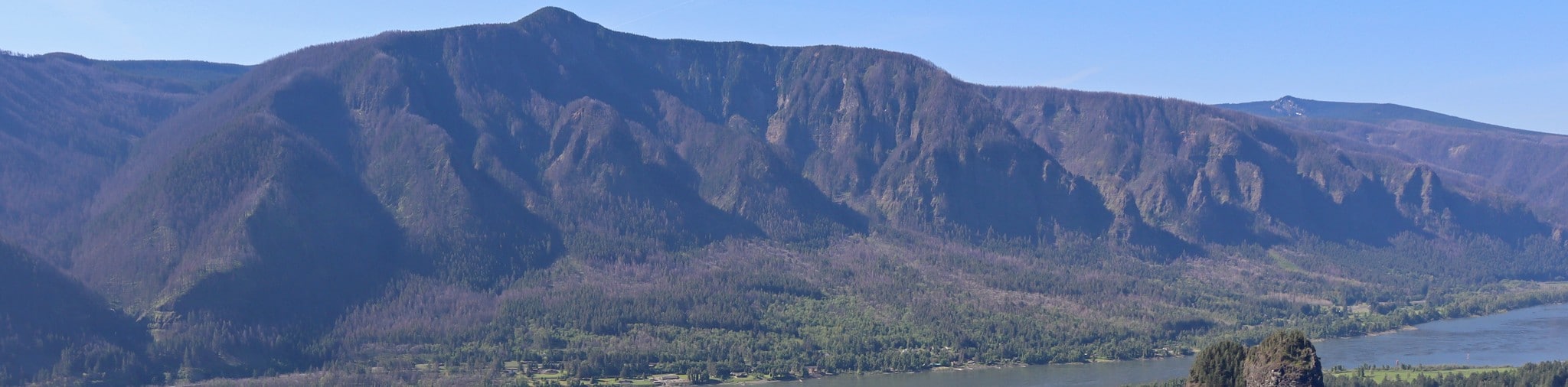
Columbia River Gorge
The view from Beacon Rock features the Columbia River Gorge, where the river slices through the mountains. You can see a wide swath of the gorge from Beacon Rock, looking across the blue flowing water to the tree-clad mountains in both directions. It’s a wonderful view!
Frequently Asked Questions
Who built Beacon Rock Trail?
Henry Biddle and Charles Johnson built the trail between 1915 and 1918. Biddle owned the rock at the time, and it was one of the first trails constructed in the area.
Can you climb Beacon Rock?
Climbers can currently use the northwestern approach to the top. Other routes are closed to protect falcon nesting habitat. The climbing routes that are open are subject to change.
Can you swim in Beacon Rock State Park?
The water in this area is not sampled for E.coli. You can swim but the water quality is not guaranteed.
Insider Hints
Remember your Discover Pass for this hike.
You can buy a day pass at the parking lot if you don’t have a Discover Pass.
Similar hikes to the Beacon Rock Trail hike

Ptarmigan Trail
Ptarmigan Trail is a 4.2mi moderate trail near the base of Mount Saint Helens. This trail is suitable…

Boundary West Trail
Boundary West Trail is a hike near Mount Saint Helens that doesn’t see much traffic, making it a nice pick…

Silver Creek Trail
Silver Creek Trail is a moderate hike in the Gifford Pinchot National Forest that is suitable for most skill levels.…
Comments