
Bertha May Lake via Teeley Trail
View Photos
Bertha May Lake via Teeley Trail
Difficulty Rating:
The hike to Bertha May Lake on Teeley Trail is a fun little adventure that can be done in just a couple of hours. This hike is 1.9mi long and takes you past Pothole Lake to blue-green Bertha May Lake on moderate terrain. If you want, you can go a bit further to Granite Lake, too. Expect moderate traffic on this route.
Getting there
The trailhead for Teeley Trail is on Forest Road 8410.

About
| Backcountry Campground | No |
| When to do | March-October |
| Pets allowed | Yes - On Leash |
| Family friendly | Yes |
| Route Signage | Average |
| Crowd Levels | Moderate |
| Route Type | Out and back |
Bertha May Lake via Teeley Trail
Elevation Graph
Weather
Bertha May Lake via Teeley Trail Description
The hike to Bertha May Lake on Teeley Trail is a quick little adventure that doesn’t require too much effort. You can relax on the shores of blue-green Bertha May Lake, perhaps making the quick side trip to Granite Lake if you want more time on this trail.
The creek on this trail can become a bit out of control in very wet conditions. We recommend hiking when it’s been a bit drier out. Additionally, the bridge is sometimes out, but it’s easy enough to traverse across the creek on foot for most adventurers.
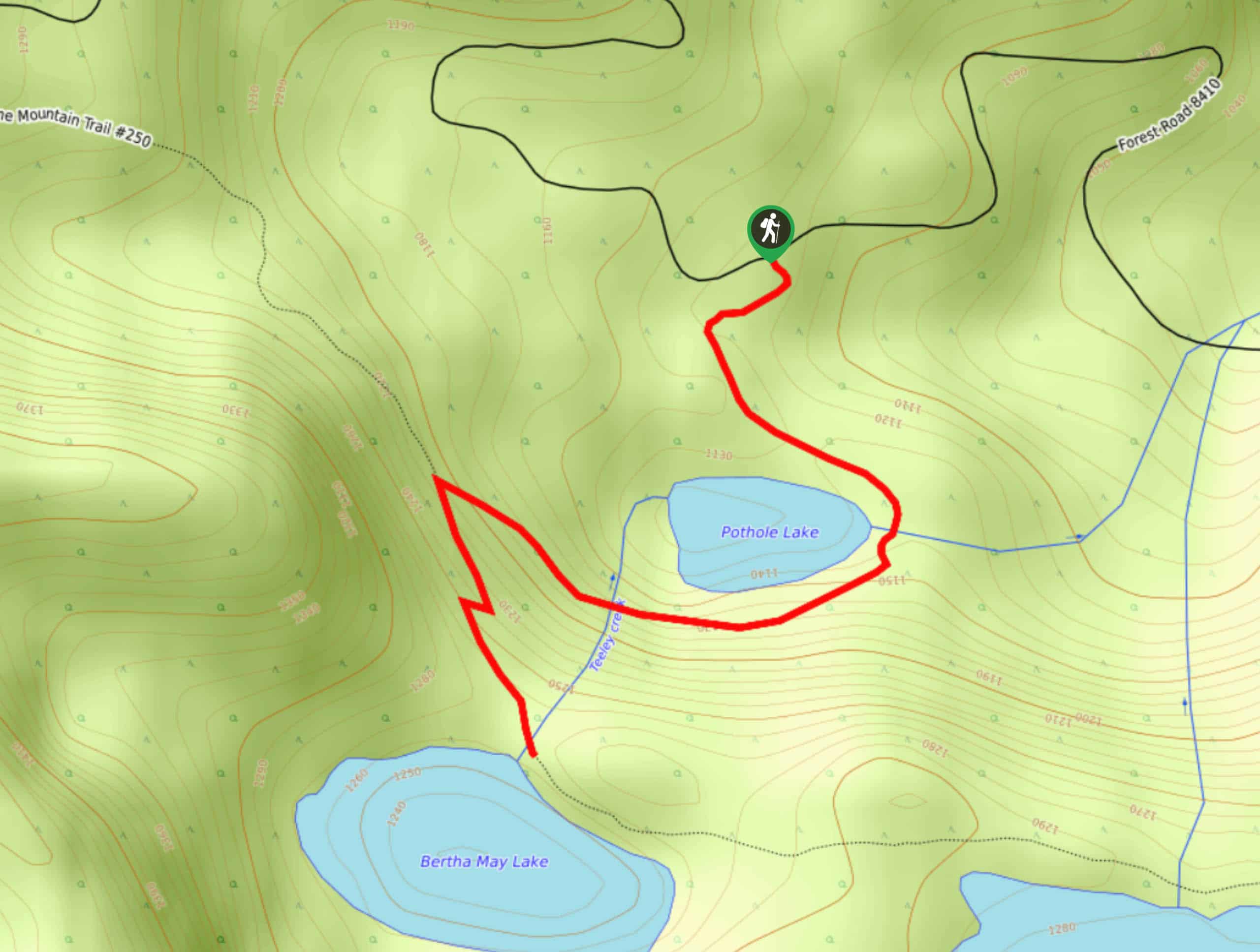
Beginning from the trailhead, you’ll make a very quick jaunt to Pothole Lake. Cross the stream at the east end of the lake and then head west to cross Teeley Creek. Make a sharp left turn at the junction and take on the hardest climbing on the trail, scaling four switchbacks to Bertha May Lake. Our guide ends here, but you can continue a short, easy way to Granite Lake on the same trail if you’d like. When you’re ready, retrace your steps.
Similar hikes to the Bertha May Lake via Teeley Trail hike

Ptarmigan Trail
Ptarmigan Trail is a 4.2mi moderate trail near the base of Mount Saint Helens. This trail is suitable…

Boundary West Trail
Boundary West Trail is a hike near Mount Saint Helens that doesn’t see much traffic, making it a nice pick…

Silver Creek Trail
Silver Creek Trail is a moderate hike in the Gifford Pinchot National Forest that is suitable for most skill levels.…
Comments