
Wintersteen Trail
View Photos
Wintersteen Trail
Difficulty Rating:
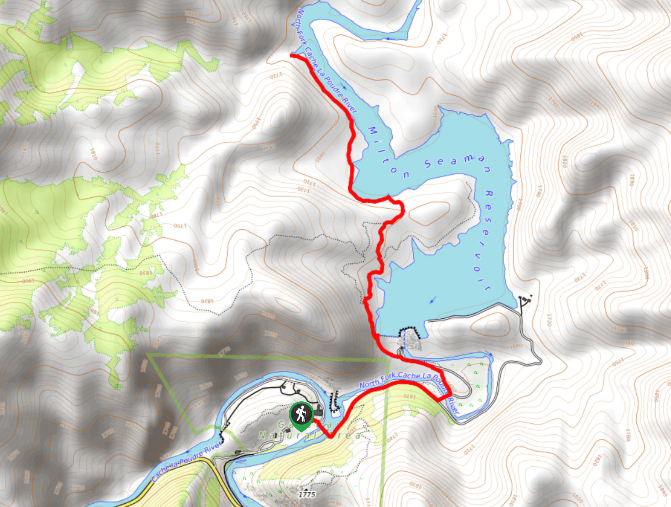
The WIntersteen Trail is an impressively diverse adventure that the whole family will enjoy. Hike along the Cache La Poudre River up to a rushing dam and along the shoreline of the Seaman Reservoir. This excursion is great for hikers of all skill-levels and kids!
Getting there
The Wintersteen Trail is accessed via the Poudre Canyon Highway in the Gateway Natural Area.

About
| Backcountry Campground | No |
| When to do | April-October |
| Pets allowed | Yes - On Leash |
| Family friendly | Yes |
| Route Signage | Average |
| Crowd Levels | Moderate |
| Route Type | Out and back |
Wintersteen Trail
Elevation Graph
Weather
Wintersteen Hike Description
The Wintersteen Hike packs a punch. Hike along the river’s edge, up and over the dam, to the crystalline, shimmering reservoir. This stimulating path will impress all its adventurers! Though this adventure is family-friendly, it’s worth noting that the trail up the dam is steep, but the route is well maintained, thus easily manageable. Located within the Gateway Natural Area, visitors must purchase a permit which typically costs around $7USD.
Embark on your adventure up the Wintersteen Trail from the Gateway Natural Area parking lot. From the carpark, take the Wintersteen Trail across the Cache La Poudre River. Hike through the canyon and along the river’s edge and up to the dam. Ascend the steep dam to the blue-hued reservoir. Continue trekking the reservoir’s shoreline until you confront an intersection. At this point, the path will merge into the Seaman Trail. This route will divert you away from the shore’s edge and into the woodlands. Follow the trail, and it will eventually spit you back out at the reservoir. Here you will notice a large boulder that visitors often jump off. If you are feeling daring, dive off the large rock into the crystal-clear waters.
Continue hiking along the Seaman Trail until the path’s end along the riverbank. Enjoy the vista of the shimmering reservoir and the mountains that hem the waters. Retrace your steps back along the trail to get back to the car park.
Similar hikes to the Wintersteen Trail hike

Miller Gulch Loop Trail
The Miller Gulch Loop Trail is a scenic meadowland adventure in the Pike National Forest. Hike through grassy meadows laden…

The Castle Hike
The Castle Hike is an exciting adventure up the steep, forested terrain to The Castle Rock. From atop the summit,…

Rutherford Trail
The Rutherford Hike is a charming nature walk in Georgetown Colorado. This secluded trail is a wonderful adventure the whole…
Comments