
Vasquez Peak Hike
View Photos
Vasquez Peak Hike
Difficulty Rating:
Immerse yourself in nature and travel up the Vasquez Peak Hike. This stunning outdoor adventure is a wonderful way to reconnect with yourself or those who you are traveling with as you hike up the mixed terrain to a mountain summit. At the summit, take a moment and enjoy the grandeur of the surrounding wilderness.
Getting there
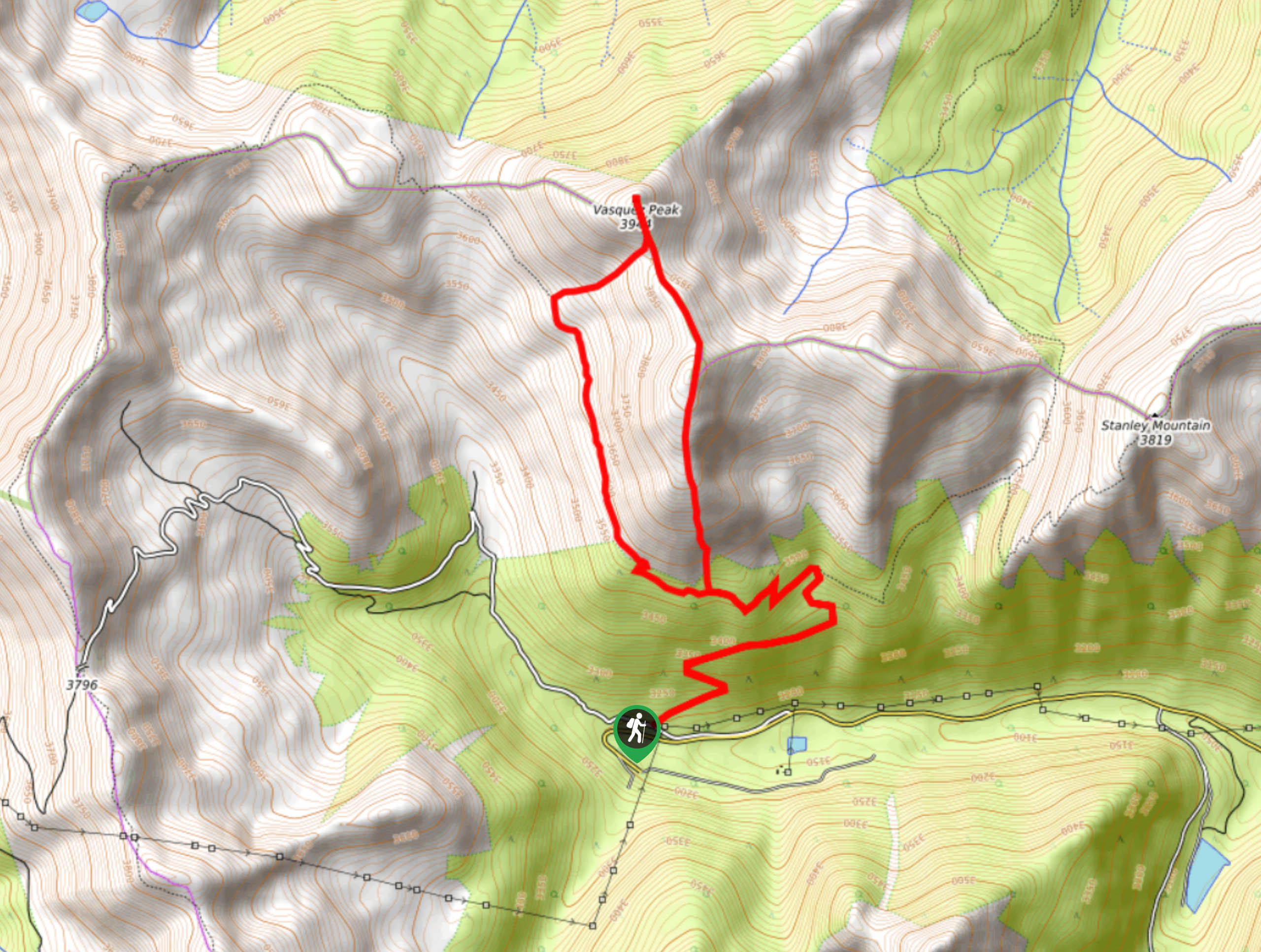
Find the Vasquez Peak Trailhead off the Henderson Mine Road.

About
| Backcountry Campground | Dispersed Backcountry Camping, restrictions apply. |
| When to do | Year-round |
| Pets allowed | Yes - On Leash |
| Family friendly | Older Children only |
| Route Signage | Poor |
| Crowd Levels | Low |
| Route Type | Lollipop |
Vasquez Peak Hike
Elevation Graph
Weather
Vasquez Peak Hike Description
The Vasquez Peak Trail is a stunning alpine adventure in the Front Range. This path is perfect for adventurous spirits who enjoy exploring the wilderness. Travel up the primitive path and use the trail GPS or go retro and use your compass to navigate the unmarked terrain. As you ascend the terrain and gain elevation, expect inclement weather and windy conditions. Check the forecast prior to setting out and wear layers! Pack plenty of water and snacks to refuel as you climb the tiring terrain.
Embark on your journey up to Vasquez Peak from the trailhead. Hike up the steep forested terrain and navigate the switchbacks. Shortly after you depart the trailhead you will meet a junction. At this point, veer left on the Berthoud Pass West Trail. Trek up the path and you will confront a fork in the road. Here, you can complete the trail from either direction, but we recommend tracking clockwise, and continuing up the Berthoud Pass West Trail. Veer left and hike up the increasingly exposed terrain into the alpine tundra. Climb along the path and you will soon have to veer right up the Vasquez Peak Trail to the summit.
Bask in the 360-degree views from the summit of Vasquez Peak. Notice the surrounding snow-dusted peaks and recharge before trekking down the summit. From the mountain top, track south along a more primitive trail down the rocky ridge. Descend the path and you will eventually meet back up with the Berthoud Pass West Trail. At this point, retrace your steps along the route back to the trailhead.
Similar hikes to the Vasquez Peak Hike hike

Hankins Pass Hike
The Hankins Pass Hike is a quintessential adventure across the Lost Creek Wilderness. The hike demonstrates the diversity of the…

Miller Gulch Loop Trail
The Miller Gulch Loop Trail is a scenic meadowland adventure in the Pike National Forest. Hike through grassy meadows laden…

The Castle Hike
The Castle Hike is an exciting adventure up the steep, forested terrain to The Castle Rock. From atop the summit,…
Comments