
Top of the World Hike
View Photos
Top of the World Hike
Difficulty Rating:
Adventure the Top of the World Hike in the Colorado wilderness. This excursion lives up to its name, trek along the incredibly scenic path to stunning overlooks. You will feel as though you are on top of the world as you navigate the technical terrain to lookouts of the Front Range peaks that flank the verdant woodlands below.
Getting there
Access the Top of the World Hike via Forest Road 550.

About
| Backcountry Campground | Dispersed backcountry camping, restrictions apply. |
| When to do | April-September |
| Pets allowed | Yes - On Leash |
| Family friendly | No |
| Route Signage | Average |
| Crowd Levels | Moderate |
| Route Type | Lollipop |
Top of the World Hike
Elevation Graph
Weather
Top of the World Hike Description
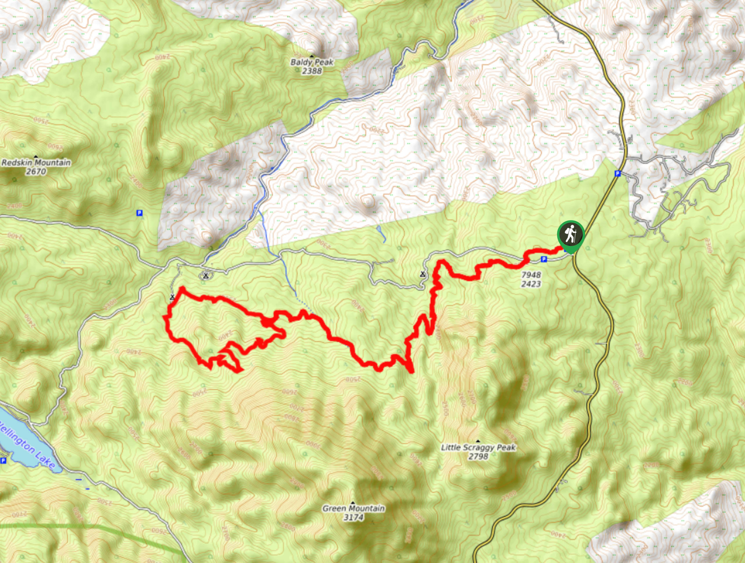
The Top of the World Trail is a must-add to your Colorado hikes adventure list. Reserved for experienced hikers with intrepid spirits, this excursion travels through undulating and technical terrain. Adventure this trail as a day-hike or an overnight backpacking excursion. This popular trail traverses the Colorado Trail Segment 3 and is trafficked by outdoor enthusiasts of all sorts. Hike it or bike it—just make sure you are prepared for a demanding adventure. Ensure to pack plenty of water and snacks to stay fueled and wear layers as insurance against windy conditions. The Top of the World Hike is not for the faint of heart, but if you seek a challenge, then you may have found your match.
Embark on your journey along the Top of the World Hike from the Colorado Trail Segment 3 Trailhead. Take the signposted trail southwestwardly. Cross the Forest Road 550 and stay right on the trail at the first intersection. Hike the undulating path through the towering pines. At the next junction, stay right, maintaining along the Colorado Trail. Mind your footing as you navigate the steep undulating terrain. The path will eventually merge with an alpine creek, stop to filter water and let your pup rehydrate. Soon you will confront a fork in the road. At this point, the loop can be completed in either direction, but we went clockwise.
Take the Green Mountain Trail and revel in the expansive vistas of the Front Ranges that line the horizon. Trek around the loop, passing the Meadows Group Campground, and merge back onto the Colorado Trail Segment 3. This path will guide you back to the beginning of the loop. From here, retrace your steps back along the trail all the way to the trailhead and parking lot.
Similar hikes to the Top of the World Hike hike

Hankins Pass Hike
The Hankins Pass Hike is a quintessential adventure across the Lost Creek Wilderness. The hike demonstrates the diversity of the…

Miller Gulch Loop Trail
The Miller Gulch Loop Trail is a scenic meadowland adventure in the Pike National Forest. Hike through grassy meadows laden…

The Castle Hike
The Castle Hike is an exciting adventure up the steep, forested terrain to The Castle Rock. From atop the summit,…
Comments