
Gray Wolf Mountain via South Chicago Creek Trail
View Photos
Gray Wolf Mountain via South Chicago Creek Trail
Difficulty Rating:
The Gray Wolf Mountain via South Chicago Creek is an epic adventure through the Mount Evans Wilderness. Hike up along the scenic creek to a stunning overlook of a mountain cirque before summiting Gray Wolf. If you don’t mind off-roading, then you will enjoy this path. Adventurous explorers will thrive as they navigate the unmarked terrain to the summit of a Colorado 13er.
Getting there
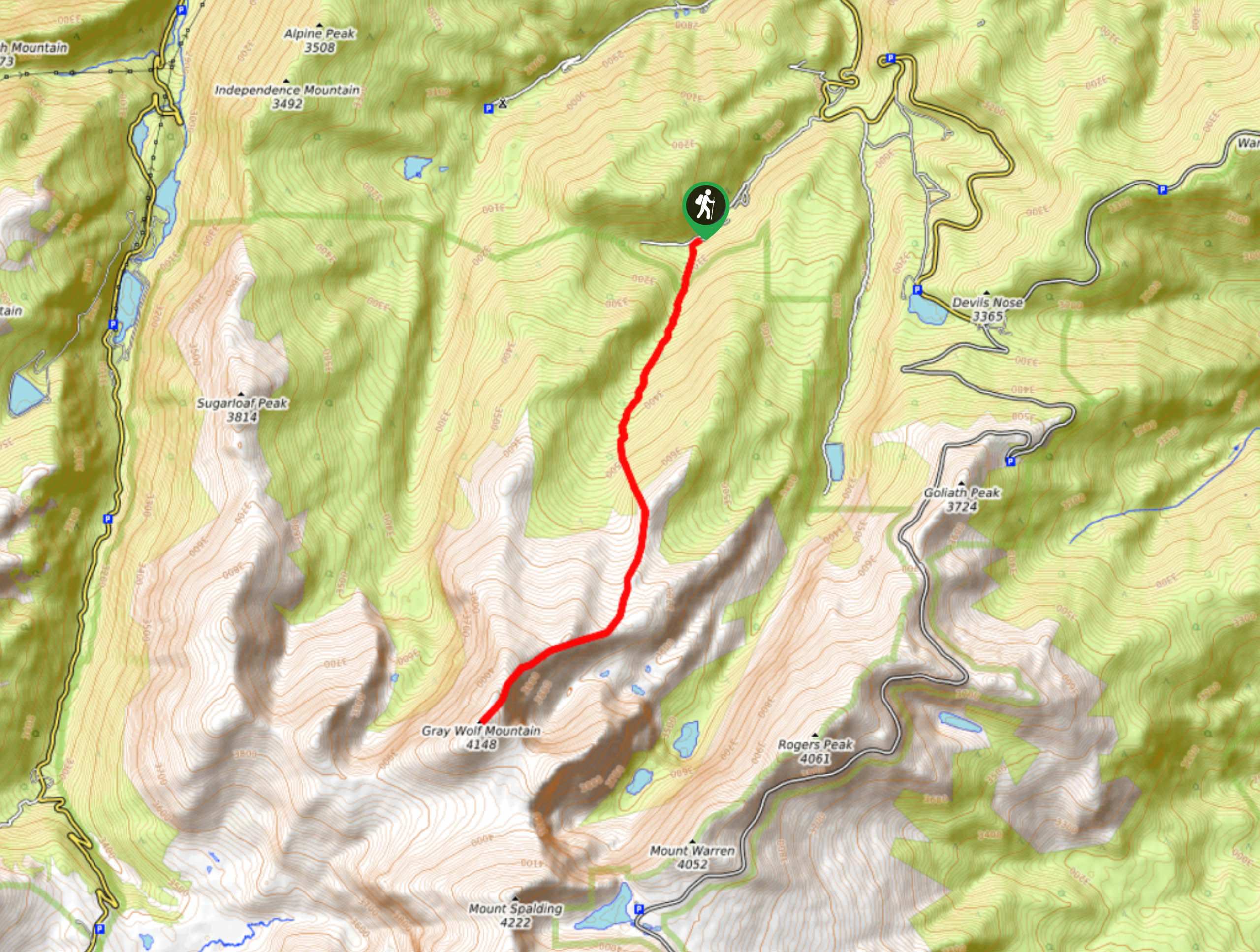
The Gray Wolf Mountain via South Chicago Creek Trail is located off Hefferman Gulch Road.

About
| Backcountry Campground | Dispersed Backcountry Camping, regulations apply. |
| When to do | April-October |
| Pets allowed | Yes - On Leash |
| Family friendly | No |
| Route Signage | Poor |
| Crowd Levels | Low |
| Route Type | Out and back |
Gray Wolf Mountain via South Chicago Creek Trail
Elevation Graph
Weather
Gray Wolf Mountain via South Chicago Creek Hike Description
We love the Gray Wolf Mountain via South Chicago Creek Hike because it is secluded, primitive and undeniably scenic. Escape the crowds of the Mount Evans wilderness and hike up the hidden gem that is the Gray Wolf Mountain via South Chicago Creek Trail. Ascend the mixed aspen and pine forest along the South Chicago Creek and up to the alpine tundra. Enjoy vistas of the neighboring snow-capped peaks as you traverse the mountain saddle to summit Gray Wolf. Be prepared for inclement weather as the rearmost section of the trail is exposed at high altitudes. Wear layers and check the forecast prior to your excursion to avoid getting caught in an afternoon storm.
The Gray Wolf Mountain via South Chicago Creek Trail begins from the South Chicago Creek Trailhead. Track south up the forested gulch and along the Chicago Creek. Enjoy sights of the vibrant aspens that tower above as you ascend the valley. Continue hiking and you will top the timberline. Here the trail will become more difficult to navigate, we would recommend using the trail GPS to help you find the route. At this point, you will be guided through the alpine tundra, keep an eye out for mountain goats! Trek the quintessential alpine terrain to the rocky saddle, overlooking a mountain cirque below and the encompassing Mount Evans peaks. The path will curve southwest as you near the summit of Gray Wolf Mountain.
Ascend the rocky mountain pass to the top of Gray Wolf Mountain. Enjoy the uninterpreted, 360-degree views of the Colorado Front Range. Revel in the breathtaking vistas before commencing your descent. When you are rested and rehydrated, backtrack along the path to the trailhead and parking lot.
Similar hikes to the Gray Wolf Mountain via South Chicago Creek Trail hike

Hankins Pass Hike
The Hankins Pass Hike is a quintessential adventure across the Lost Creek Wilderness. The hike demonstrates the diversity of the…

Miller Gulch Loop Trail
The Miller Gulch Loop Trail is a scenic meadowland adventure in the Pike National Forest. Hike through grassy meadows laden…

The Castle Hike
The Castle Hike is an exciting adventure up the steep, forested terrain to The Castle Rock. From atop the summit,…
Comments