
Thunder Butte Hike
View Photos
Thunder Butte Hike
Difficulty Rating:
The Thunder Butte Hike is an epic outdoor excursion for those who don’t mind blazing their own trail. This trail is overgrown and primitive, so it is very hard to follow, but if you have the trail GPS and a keen sense of adventure, you will enjoy this expedition into the wilderness.
Getting there
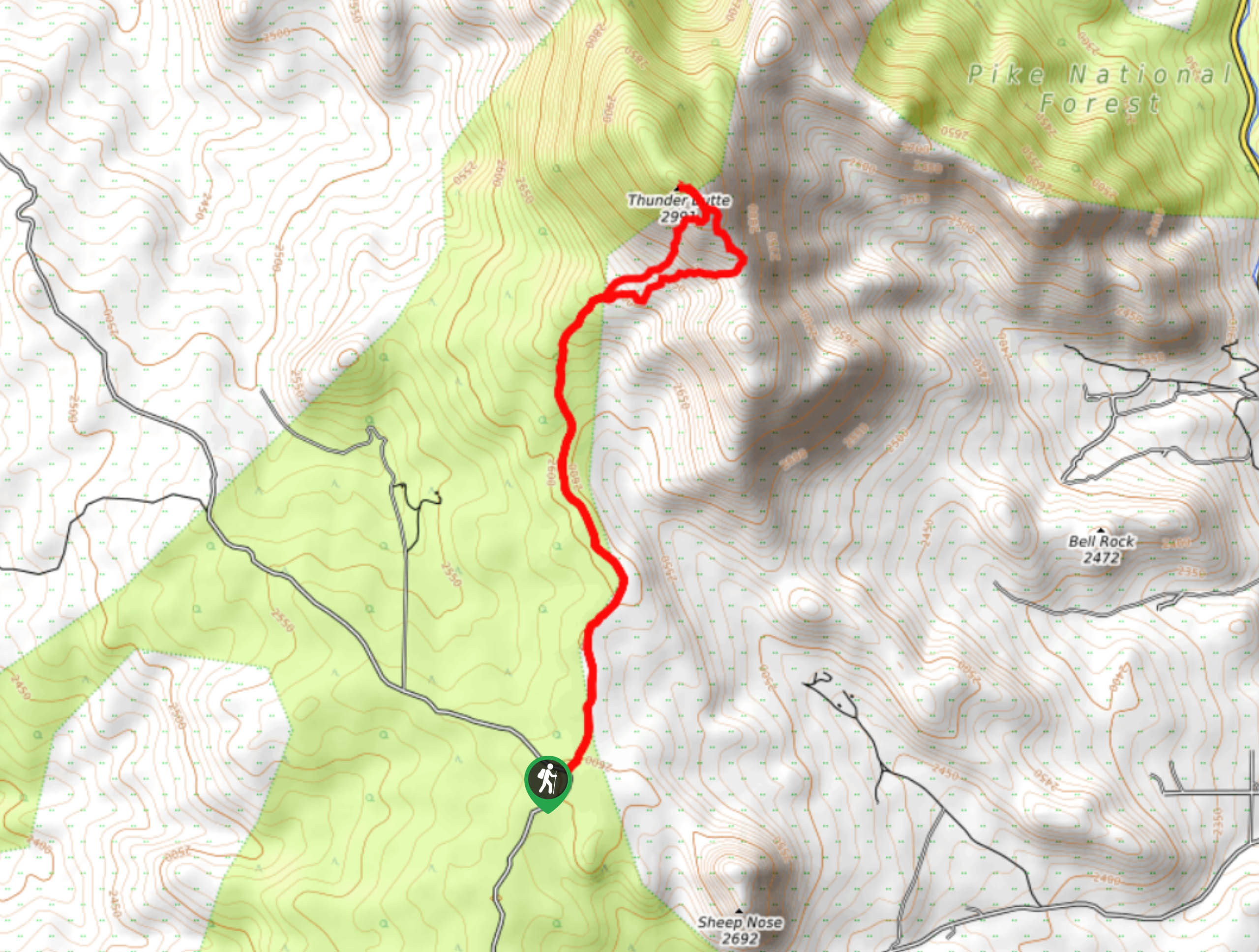
Find the Thunder Butte Trailhead off W 9-J Road.

About
| Backcountry Campground | Dispersed backcountry camping, restrictions apply. |
| When to do | April-October |
| Pets allowed | Yes - On Leash |
| Family friendly | Older Children only |
| Route Signage | Poor |
| Crowd Levels | Low |
| Route Type | Lollipop |
Thunder Butte Hike
Elevation Graph
Weather
Thunder Butte Hike Description
Experience the stunning Colorado wilderness on the Thunder Butte Trail. Hike through grassy meadowlands, under pine forest shade and up a rocky ridge to the summit overlooking the surrounding wilderness. This path is almost entirely exposed, so be prepared for windy weather as you gain elevation. Additionally, parts of this path were burned in the Hayman Fire. Hike through the eerie burn and notice the scorched trees. As we mentioned, this trail is not well marked. We recommend using the trail GPS to help you navigate the hike.
Departing from the trailhead, the Thunder Butte Trail tracks northeast through a vast meadow. Walk through the open plains and admire the rolling mountains that line the horizon. Hike the route as you near the pine forest. Here you will notice the left-over burn and new vegetation that has begun to grow in the area. Hike through the pine woodlands and you will encounter a junction. At this point, you can complete the loop up to Thunder Butte Mountain from either direction, but we recommend going clockwise. Take the rocky path up through the sparse tree coverage. Travel northwest up to the summit of Thunder Butte. Enjoy the spectacular vistas of the mountainous Colorado landscape from the overlook.
Once you are through admiring the scenery, track southeast down the mountainside. Hike down the saddle and curve southwest. Eventually, you will meet back at the intersection. From this point, retrace your steps along the Thunder Butte meadow trail back to the parking lot.
Similar hikes to the Thunder Butte Hike hike

Hankins Pass Hike
The Hankins Pass Hike is a quintessential adventure across the Lost Creek Wilderness. The hike demonstrates the diversity of the…

Miller Gulch Loop Trail
The Miller Gulch Loop Trail is a scenic meadowland adventure in the Pike National Forest. Hike through grassy meadows laden…

The Castle Hike
The Castle Hike is an exciting adventure up the steep, forested terrain to The Castle Rock. From atop the summit,…
Comments